Ticker for June 6, 2007
MESONET TICKER ... MESONET TICKER ... MESONET TICKER ... MESONET TICKER ...
June 6, 2007       June 6, 2007       June 6, 2007       June 6, 2007


May 2007: Something for Everyone

Quick Test: Was May 2007 warmer or cooler than normal? What do you
think? Well, if you thought May was warmer than normal, congratulations,
you were right. And if you thought May was cooler than normal, you were
right too. Kind of. Almost.

Let us explain:

According to the Mesonet Monthly Summary for May 2007, the overall
statewide average temperature this May was 68.9F. That's 1.0F above
normal, which would validate the "I thought May was warmer" guess.

However, digging a little deeper into the numbers kinda validates the
other guess as well. Maximum temps for May were cooler than normal.
And, because maximum temps are observed at a time when we are out
and about exercising our daily humanity, it's only natural to guess
on the cool side.

Here are the numbers:

Maximum Temperatures     Minimum Temperatures
2007  Normal   Diff      2007  Normal   Diff
Bartlesvl    78.9    80.5   -1.6      59.4    56.9   +2.5
Clinton      78.1    80.1   -2.0      60.3    56.0   +4.3
Frederick    80.6    82.7   -2.1      62.1    57.4   +4.7
Gage         78.0    78.6   -0.6      56.3    52.5   +3.8
Guthrie      79.0    80.2   -1.2      61.6    55.7   +5.9
Hobart       78.9    81.5   -2.6      59.7    57.0   +2.7
Lawton       80.2    81.5   -1.3      62.6    59.4   +3.2
McAlester    78.8    80.0   -1.2      62.0    58.6   +3.4
Muskogee     79.5    79.2   +0.3      61.2    58.2   +3.0
Okla City    79.2    78.9   +0.3      62.7    57.9   +4.8
Ponca        78.3    79.0   -0.7      62.0    57.3   +4.7
Stillwater   78.5    79.3   -0.8      61.4    56.9   +4.5
Tulsa        79.5    79.6   -0.1      61.7    59.0   +2.7

Why the discrepancy?

Well, it has a lot to do with cloudiness. May was a very rainy month
for most of the state. As any four-year-old with a crayon can show you,
rain comes from clouds. And clouds modify the diurnal temperature
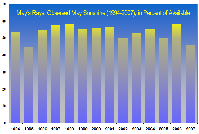
range. Mesonet numbers indicate that May 2007 was the least sunny May
since 1995, which is an indicator of substantial daytime cloudiness.


Substantial daytime cloudiness is a good predictor of two things:

1. Lower daytime temps (which showed up in the data), because clouds
block a great deal of sunlight.
2. Substantial nighttime cloudiness

Substantial nighttime cloudiness helps keep temperatures up, because,
to use a horrible, horrible analogy ... the clouds "act like a blanket"
overnight, which helps keeps temps up.

We can't resist: the clouds don't act exactly like a blanket. They,
along with the copious water vapor among them, absorb and re-transmit
longwave radiation, which prevents rapid cooling at the surface. This
is different than what a blanket does.

Wait, wait. We're wrong. Actually a blanket does a tiny amount of that
too. But that's not the point. Blankets help trap air, which adds to
the whole process.

Wait, scratch that last paragraph. We're getting frustrated here.

Let's just say the clouds "act like a blanket" overnight (in a tiny way),
and leave it at that.

Where's the Tylenol?
June 6 in Mesonet History
| Record | Value | Station | Year |
|---|---|---|---|
| Maximum Temperature | 104°F | CHER | 2011 |
| Minimum Temperature | 38°F | BOIS | 1998 |
| Maximum Rainfall | 4.75″ | TULN | 2019 |
Mesonet records begin in 1994.
Search by Date
If you're a bit off, don't worry, because just like horseshoes, “almost” counts on the Ticker website!