Ticker for January 18, 2007
MESONET TICKER ... MESONET TICKER ... MESONET TICKER ... MESONET TICKER ...
January 18, 2007   January 18, 2007   January 18, 2007   January 18, 2007


Long Sub-Freezing Stretch

Last week's cold blast has hung around for a while, and with a
reinforcing blow to be delivered soon, we might end up with one
of the coldest Januaries in recent memory. Here's a post-mortem
of the time spent below freezing (which might a pre-mortem of things
to come?).

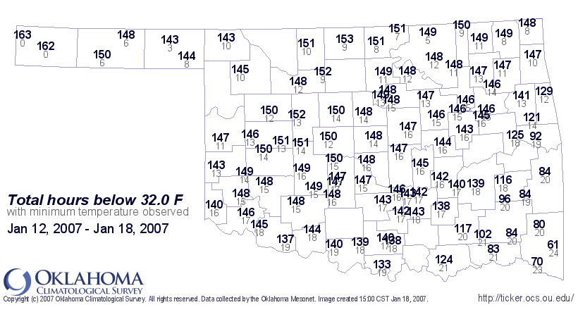
First, the total number of hours below freezing in the last six days:


(this map also shows the coldest temp observed at each station)

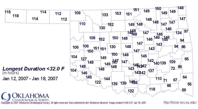
Second, the longest run of hours below freezing. Some stations spent
almost six full days below the freezing mark!


Today's thaw (yesterday in some places) brings up an important point.
Each ice storm's Inevitable Melt brings a secondary period of hazard
for power companies and their customers. When transmission lines dump
hundreds of pounds of ice at once, the violent spring back upward
sometimes causes more damage to the electric infrastructure than
the icing itself (which took hours to accumulate).


In case you're wondering, here are the longest known stretches below
freezing for several Oklahoma locations:

Station          # Days    Thaw Date
Oklahoma City        13    Dec 31, 1983
Tulsa                13    Dec 31, 1983
Ada                  12    Dec 30, 1983
Alva                 13    Jan 12, 1979
Ardmore              12    Dec 31, 1983
Durant               13    Dec 31, 1983
Enid                 22    Jan 29, 1930
Hobart               12    Dec 31, 1983 and Mar 6, 1960
Newkirk              18    Jan 25, 1930
Stillwater           13    Dec 31, 1983
January 18 in Mesonet History
| Record | Value | Station | Year |
|---|---|---|---|
| Maximum Temperature | 78°F | WAUR | 2022 |
| Minimum Temperature | 2°F | KENT | 2008 |
| Maximum Rainfall | 1.28″ | HASK | 2023 |
Mesonet records begin in 1994.
Search by Date
If you're a bit off, don't worry, because just like horseshoes, “almost” counts on the Ticker website!