Ticker for July 27, 2006
MESONET TICKER ... MESONET TICKER ... MESONET TICKER ... MESONET TICKER ...
July 27, 2006      July 27, 2006      July 27, 2006      July 27, 2006


Updated Drought Statistics

As circumstances place more and more time between the last appreciable
rainfall and the present, it's time for us to re-visit some drought
statistics for Oklahoma.

First of all, here are the historical placements of recent precip
totals compared to the 86 such cycles since the modern climate
record matured in 1921.

Historical Rank of Recent Precip by Time Scale
(compared to periods ending July 27th; 1st=driest, 86th=wettest)

OK Region   30day   60day   90day  120day  180day    1year    2year

Panhandle    34th    21st     9th     5th     3rd      6th     24th
N. Central   10th    15th     6th     9th     6th      5th     17th
Northeast    48th    18th    18th    30th    19th      5th      8th

W. Central   17th    33rd    22nd    11th    11th     21st     48th
Central      39th    31st    17th    13th     9th      7th     15th
E. Central   32nd    20th    18th    17th    12th      3rd      9th

Southwest    18th     9th     6th     5th     3rd      6th     16th
S. Central   12th     2nd     4th     4th     7th      5th     12th
Southeast     2nd    17th    21st    14th    16th      1st      1st

Statewide    18th    10th    10th     7th     8th      3rd     10th


Driest Such Period Since
(compared to periods ending July 27th)

OK Region   30day   60day   90day  120day  180day    1year    2year

Panhandle    2003    2001    1990    1974    1970  2001-02  2001-03
N. Central   2003    2003    1990    1990    1996  1955-56  2000-02
Northeast    2005    2001    1998    2005    2005  1995-96  1979-81

W. Central   2003    2003    2003    1998    1996  2001-02  2001-03
Central      2003    2003    2003    2003    1972  1980-81  1979-81
E. Central   2003    1998    2005    2005    2005  1935-36  1979-81

Southwest    2003    2001    1998    1998    1966  1970-71  1982-84
S. Central   2003    1925    1998    1998    1972  1963-64  1979-81
Southeast    1993    1998    2005    2005    2005   Driest   Driest

Statewide    2003    1998    1998    1998    1972  1955-56  1979-81


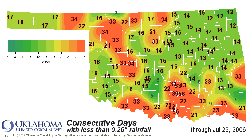
Also, it has been more than a month since significant rain fell in
parts of southern and northwestern Oklahoma:


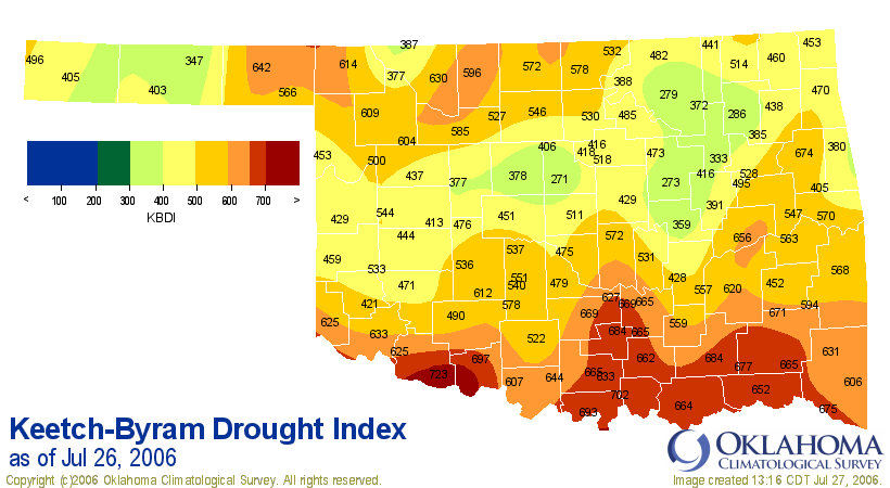
Finally, the Keetch-Byram Drought Index has reached extreme proportions
near the Red River:


As always, these statistics and several others are updated daily at the
Oklahoma Drought Update:

http://climate.mesonet.org/drought/
July 27 in Mesonet History
| Record | Value | Station | Year |
|---|---|---|---|
| Maximum Temperature | 112°F | ALV2 | 2011 |
| Minimum Temperature | 49°F | KENT | 2005 |
| Maximum Rainfall | 4.96″ | YUKO | 2020 |
Mesonet records begin in 1994.
Search by Date
If you're a bit off, don't worry, because just like horseshoes, “almost” counts on the Ticker website!