Ticker for August 31, 2005
MESONET TICKER ... MESONET TICKER ... MESONET TICKER ... MESONET TICKER ...
August 31, 2005    August 31, 2005    August 31, 2005    August 31, 2005


The Remains of the Day

Earlier today, the Entire Ticker Staff made a meteogram for an OCS
customer (a researcher at NOAA HQ) and something caught our eye.
And this something that caught our eye might have been something
to catch our eye had we been there in person eyeing the sky.

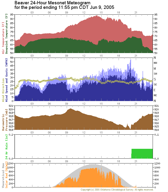
Anyway, the meteogram was for Beaver, June 5th of this year:


Notice the solar radiation curve in the bottom panel. You will see
the choppy, up and down indications of intermittent cloudiness through
most of the afternoon. But peer a little closer at the trace around
and after the time of sunset. Notice the little orange upward blip?
That last little nudge upward after the celestially-designated onset
of nighttime? The Mesonet sensor actually recorded some sunlight
after sunset ... and the values of close to 30 watts per square meter
are more than twilight can offer.

What happened? Did the earth's rotation slow down? Did the people
of Beaver plead successfully for the earth to spin momentarily back
westward toward the sun before rolling eastward into our dreams -
replaying the day's last few minutes like a planetary-scale TiVo?
Did the Sun jump to a new place in the solar system?

Well, to put your fears at ease, we believe that the answer to all
these questions is no. As far as we can tell, the earth and sun still
obey the same universal and celestial laws that were in place before
June 5th. Clues toward an explanation lie in the rest of the meteogram.

In the hours before sunset, the meteorological variables show some
significant and synchronous signals. The wind peaks near 55 mph.
The pressure spikes upward and downward. The temperature and dewpoint
fluctuate. The solar radiation bottoms out near zero. And, a bit of
rainfall was observed in the gauge. These are all symptoms of ... you
guessed it: a passing thunderstorm.

Storms are often quite tall, especially summertime storms, which means
they can be illuminated by the setting sun much longer than the
surface. And storms often move with an eastward component, which was
the case on June 5th.

So, the phantom sunlight was nothing more than reflected light from
a passing storm to the east. It was probably a pretty sight, and
would've caught your eye had you been there.
August 31 in Mesonet History
| Record | Value | Station | Year |
|---|---|---|---|
| Maximum Temperature | 111°F | FREE | 2011 |
| Minimum Temperature | 45°F | NOWA | 2009 |
| Maximum Rainfall | 5.29″ | YUKO | 2020 |
Mesonet records begin in 1994.
Search by Date
If you're a bit off, don't worry, because just like horseshoes, “almost” counts on the Ticker website!