Ticker for October 6, 2004
MESONET TICKER ... MESONET TICKER ... MESONET TICKER ... MESONET TICKER ...
October 6, 2004 October 6, 2004 October 6, 2004 October 6, 2004
With Humidity, It's All Relative
The following graphic shows the average daily cycle of relative
humidity and air temperature at three Oklahoma Mesonet stations
from 1994-2003.
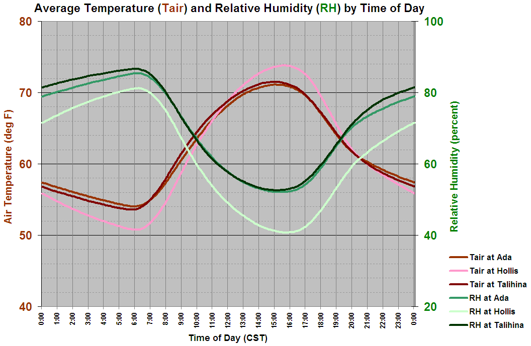
The most outstanding feature in the RH cycle is a pronounced dip
during the day, followed by recovery in the overnight hours through
sunrise. This reflects the "relative" part of "relative humidity".
Because warm air can "hold" more water vapor than cooler air, the
same absolute moisture values will comprise lower RH's in warmer air.
Also, daytime mixing can play a role in the dispersion of
near-surface moisture to higher levels of the atmosphere. At night,
the atmosphere is more stable, surface winds are typically calmer,
and surface winds are significantly more easterly. The combination
of these three climatological factors helps RH values soar overnight.
A few more subtle things to notice:
1. The nighttime RH recovery isn't nearly as rapid as the daytime
RH decline
2. RHs decline more rapidly and more deeply at Hollis (in the west)
versus Ada and Talihina, in central and eastern Oklahoma.
3. The air temperature trace at Hollis has a higher amplitude (it
starts colder and finishes warmer) than its eastern, more humid
counterparts.
October 6 in Mesonet History
| Record | Value | Station | Year |
|---|---|---|---|
| Maximum Temperature | 95°F | FREE | 2016 |
| Minimum Temperature | 27°F | KENT | 2013 |
| Maximum Rainfall | 7.75 inches | JAYX | 2019 |
Mesonet records begin in 1994.
Search by Date
If you're a bit off, don't worry, because just like horseshoes, “almost” counts on the Ticker website!