Ticker for December 15, 2003
MESONET TICKER ... MESONET TICKER ... MESONET TICKER ... MESONET TICKER ...
December 15, 2003 December 15, 2003 December 15, 2003 December 15, 2003
That's one Power-Packed Weather Map!
Just one Mesonet weather map from this afternoon shows a plethora,
a menagerie, and a cornucopia of weather features! In fact, it's
almost (almost) hard to imagine so many features on one map.
Take a look at this afternoon's 1:30 pm weather map:
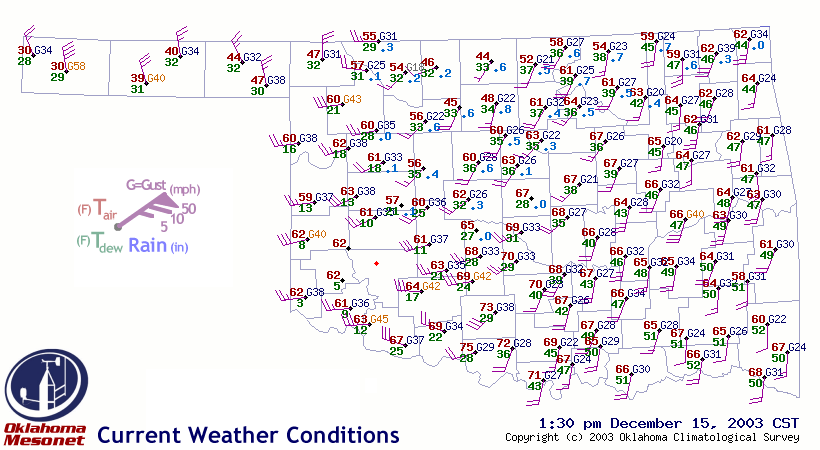
There's a bunch going on! To wit:
Strong Cold Front / Northwest:
Very brisk winds and colder air have invaded the state. In fact,
wind gusts at Boise City (western panhandle) hit 58 mph, which
exceeds the criteria for a severe thunderstorm! At 1:30 the
air temperature was 30F with winds gusting to 58 mph ... that's
one heck of a wind chill!
Dry Line / Southwest:
Brisk westerly surface winds and VERY low dew points signalled
a dryline invasion in extreme southwest Oklahoma. Take a look
at the dewpoint temps at Hollis, Mangum, Altus and Erick ...
they're in the single digits! In fact, the RH dropped below 3%
for a time at Hollis.
Check out the wind-borne dust coming from the Texas panhandle:

The dry line screamed eastward in the subsequent two hours, and
many of us in the Ticker Building are now getting a mouthful of
Tucumcari.
Windy and Unseasonably Mild / Southeast half of state:
Temperatures exceeded 70 degrees today in much of Oklahoma, as
today was windy, almost humid and almost warm in advance of the
aforementioned cold front.
Snowmelt & Snowcover / North Central:
Air temperatures were held down by a snow belt in northern Oklahoma,
which is evidenced by the phantom rainfall (actually snowmelt) on
the map. Notice the decidedly lower temperatures in the snowbelt
region.
Snowbreeze Impact / Same region:
The synoptic scale demanded strong southerly-to-southwesterly winds
over that snow belt, but a snow breeze which developed added a
mesoscale northerly component. The result was noticable diminished
southwesterly flow over the snowbelt region.
Frozen Wind Monitors / Hobart, Retrop and Mangum:
Icing over the weekend rendered the propellors at several sites
useless as they were encased in frozen stuff. The Mesonet QA
Manager flagged the subsequent wind data as "unsusable" and is
in the process of restoring the good data that came back when
the ice melted.
Few places on earth offer the wide variety of conditions we saw today,
and only Oklahoma offers the dense instrumentation that lets us see it!
December 15 in Mesonet History
| Record | Value | Station | Year |
|---|---|---|---|
| Maximum Temperature | 83°F | SEIL | 2021 |
| Minimum Temperature | 2°F | KENT | 2008 |
| Maximum Rainfall | 1.99 inches | BBOW | 2001 |
Mesonet records begin in 1994.
Search by Date
If you're a bit off, don't worry, because just like horseshoes, “almost” counts on the Ticker website!