Ticker for July 31, 2003
MESONET TICKER ... MESONET TICKER ... MESONET TICKER ... MESONET TICKER ...
July 31, 2003 July 31, 2003 July 31, 2003 July 31, 2003
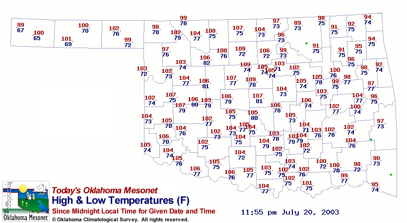
Very High Lows!
While the entire Ticker Staff was on assignment in Reno, some record
high lows were set in Oklahoma. The 20th, and especially the 21st,
saw some whopper low temps:
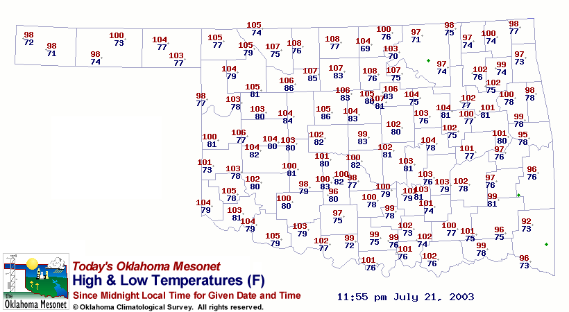
Notice those mid-80s low temps northwest of OKC on the 21st! What's
causing those maximal minimums? A combination of several factors:
1. It's summer, and summer is hot
2. These nights were breezy, which kept things mixed up (and warmer)
near the surface
3. There was considerable cloudiness at the mid-levels, which kept
radiative cooling to a minimum
Okay, these are three important factors. But these happen in concert
enough that they alone shouldn't cause record overnight warmth, so
there's got to be another factor ...
... and there is.
The fourth factor, the one that made the ultimate difference, was
the wind direction. Take a look at a weather map from the wee hours
of the 21st:
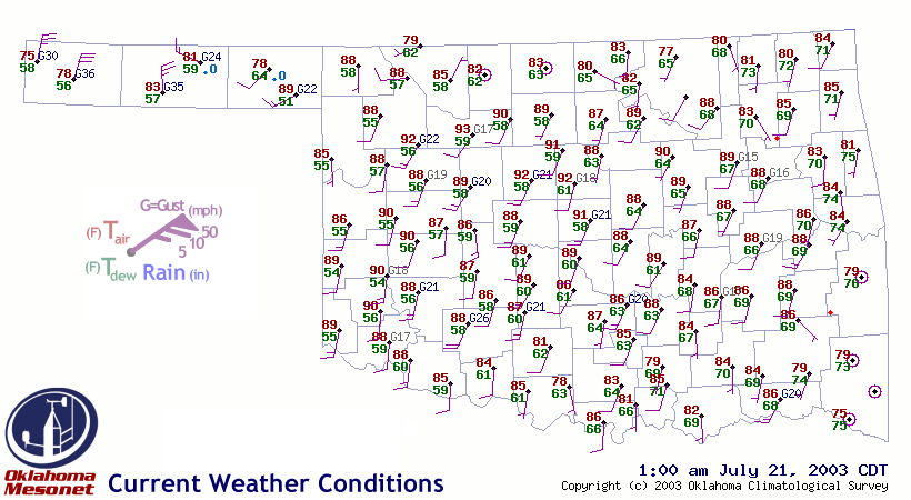
Those winds are breezy AND from the south-southwest. That's a bit
interesting in itself, because summertime overnight winds in Oklahoma
most often have an easterly component. It's here that Oklahoma's
geography comes into play. Those south-southwesterly winds were
blowing straight up Oklahoma's winter wheat belt, where the crop
been harvested, burned (sometimes) and tilled by July.
So, the surface winds were blowing straight up this alley of
reddish-brown clay, which has a heat capacity reminiscent of the
urban terrain. By the time they reached the northern reaches of the
winter w(Heat) belt, these near-surface parcels had acquired some
serious heating! And that's what held many lows at an all-time high
on the 21st.
(note: the mid-70s lows in the northern tier of counties were
actually set in the PM hours of the 21st as a welcome cold front
sagged into the state ... the morning lows were just as miserable
as the Enid/Kingfisher area lows)
Special thanks to Ticker subscriber Vince Miller for tipping us off
to this event!
July 31 in Mesonet History
| Record | Value | Station | Year |
|---|---|---|---|
| Maximum Temperature | 112°F | MANG | 2012 |
| Minimum Temperature | 50°F | BOIS | 2018 |
| Maximum Rainfall | 5.02 inches | CLAY | 2014 |
Mesonet records begin in 1994.
Search by Date
If you're a bit off, don't worry, because just like horseshoes, “almost” counts on the Ticker website!