Ticker for July 30, 2003
MESONET TICKER ... MESONET TICKER ... MESONET TICKER ... MESONET TICKER ...
July 30, 2003 July 30, 2003 July 30, 2003 July 30, 2003
Severe Winds and Heavy Rain
As is often the case in drought episodes, heavy rainfall came with
a violent pricetag overnight. The Norman Mesonet station recorded
wind gusts of 64, 66, 79, 69 and 61 mph in consecutive five-minute
periods from 6:05 to 6:25. That 79 mph wind gust was observed
with a five-minute-averaged wind speed of 57 mph! Mesonet lead
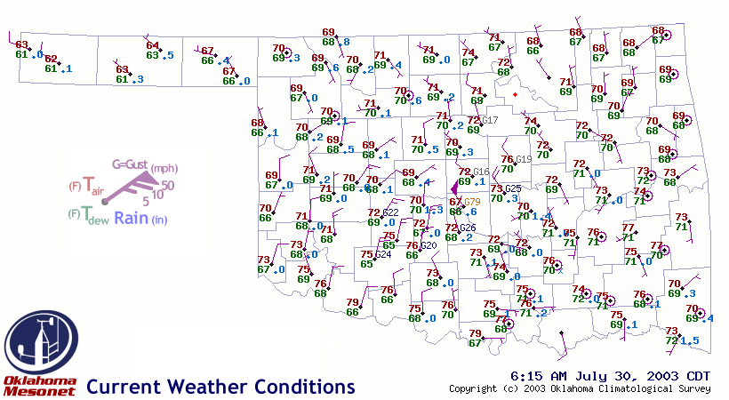
operator David Demko captured the associated weather map, which
was donned with an elusive wind pennant (signifying average winds
of 50 mph or greater):
Several locations received up to two inches of rain during the event.
Like most summer convection, local rainfall amounts are highly
variable. Here are selected rainfall totals from the Oklahoma
Mesonet:
Bowlegs 2.32" Hooker .71"
Norman 1.98" Kingfisher .69"
Goodwell 1.58" Lahoma .65"
Idabel 1.52" Stuart .63"
Minco 1.40" Putnam .51"
Ardmore .97" Guthrie .49"
May Ranch .79" El Reno .46"
Upon Further Review ...
Dr. Jeanne Schneider of the USDA Agricultural Research Service pointed
out a faux pas in yesterday's edition of the Ticker: the chaotic winds
weren't guided by mesoscale whimsy, but by whimsy on much finer scales!
That's right, the whole chain of command was AWOL yesterday, leaving
boundary-layer processes and eddies in charge of the wind field
across much of the state.
Thank you for keeping us honest!
July 30 in Mesonet History
| Record | Value | Station | Year |
|---|---|---|---|
| Maximum Temperature | 111°F | CHER | 2012 |
| Minimum Temperature | 54°F | BOIS | 2004 |
| Maximum Rainfall | 4.89 inches | SPEN | 2014 |
Mesonet records begin in 1994.
Search by Date
If you're a bit off, don't worry, because just like horseshoes, “almost” counts on the Ticker website!