Ticker for June 26, 2003
MESONET TICKER ... MESONET TICKER ... MESONET TICKER ... MESONET TICKER ...
June 26, 2003 June 26, 2003 June 26, 2003 June 26, 2003
Mesonet Product Suite Adds Flood Awareness Tool
Although violent weather often makes the headlines, flooding kills
more people in the U.S. than any other severe weather type.
And, while often omitted from the "severe weather" stream of
consciousness, the consequences of flooding on lives and property
are quite severe. Unfortunately (or fortunately, depending on your
point of view), the entire Ticker staff can personally attest to
the destructive power of even slow-moving water.
This year, the National Weather Service launched its "Turn Around
Don't Drown" campaign to increase public awareness of flood safety.
In the same spirit, a new product has been added to the Mesonet's
suite.
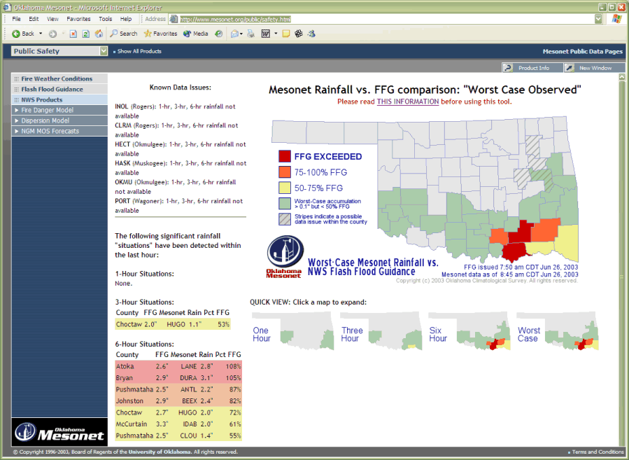
The "Meso-vs-FFG" is the latest Mesonet "hybrid" product, in that
it splices two very valuable sources of information: flash flood
guidance (FFG) from the NWS, and real-time rainfall data from the
Oklahoma Mesonet.
Here's how it works: three times a day, the NWS River Forecast
Center in Tulsa issues one-hour, three-hour, and six-hour FFG.
These values are estimates of the amount of rain required in
a given time for flash flooding to occur in the county. Mesonet
data is updated every 15 minutes and analyzed to determine if
rainfall amounts are encroaching on these critical values. Maps
and tables display, with a yellow-orange-red color scheme, which
rainfall values are greater than 50, 75 or 100 percent of FFG.
As with all products, there are issues to consider, such as
comparing point-level Mesonet rainfall with county level guidance.
And this product will never replace the expertise of your local
NWS Forecast Office and emergency management officials.
However, the product is intended to provide an easily-visible and
"always-on" view of flood threats to forecasters and emergency
managers, who may need to allocate much of their energies to
dealing with violent weather.
The new product is listed under the "Public Safety" tab of the
Oklahoma Mesonet data pages:
http://www.mesonet.org/public/safety.html
P.S. The product got a real workout this morning, on its second day
on the job:
June 26 in Mesonet History
| Record | Value | Station | Year |
|---|---|---|---|
| Maximum Temperature | 115°F | HOLL | 2011 |
| Minimum Temperature | 52°F | KENT | 2006 |
| Maximum Rainfall | 5.51 inches | MIAM | 2021 |
Mesonet records begin in 1994.
Search by Date
If you're a bit off, don't worry, because just like horseshoes, “almost” counts on the Ticker website!