Ticker for May 8, 2003
MESONET TICKER ... MESONET TICKER ... MESONET TICKER ... MESONET TICKER ...
May 8, 2003 May 8, 2003 May 8, 2003 May 8, 2003
Strong Storms Strike Southern Oklahoma
As is often the case during spring in Oklahoma, welcome rainfall came
with a violent pricetag over the last few days. Last night (and into
this morning), strong storms dumped locally-heavy rainfall on areas
of southern Oklahoma that are experiencing a very dry spring.
Unfortunately, they also brought along large hail, strong winds and
tornadoes.
Several Mesonet sites experienced storms directly. Three examples
come from Ringling, McAlester and Wister:
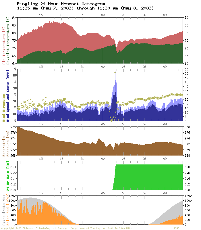
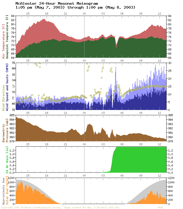

All three sites show clear evidence of storm passage: gusty winds,
a blast of rain-cooled air, a local pressure drop in advance of
the storm, and brief, but very heavy rainfall (an inch and a half
at Wister in about 40 minutes!).
The McAlester meteogram also shows some very interesting undulations
in the pressure field during the hours before the event.
Rainfall varied widely by location in southern Oklahoma, which is
also a typical symptom of springtime storms around here. Some
locations did receive helpful short-term drought relief while
others got only got wet ground. Here are selected 48-hour rainfall
totals from the Mesonet:
Wister 2.40"
Bee 1.63" (nearby Tishomingo: 0.13")
McAlester 1.54"
Medicine Park 1.19"
Clayton 1.28" (nearby Cloudy: 0.11")
Cookson 1.65" (nearby Tahlequah: 0.00")
Walters 0.94" (nearby Grandfield: 0.09")
WIlburton 0.94"
Ardmore 0.93"
Waurika 0.88"
Tipton 0.87" (nearby Altus: 0.01")
May 8 in Mesonet History
| Record | Value | Station | Year |
|---|---|---|---|
| Maximum Temperature | 108°F | ALTU | 2011 |
| Minimum Temperature | 34°F | CHER | 2010 |
| Maximum Rainfall | 5.86 inches | FTCB | 2007 |
Mesonet records begin in 1994.
Search by Date
If you're a bit off, don't worry, because just like horseshoes, “almost” counts on the Ticker website!