Ticker for May 28, 2002
MESONET TICKER ... MESONET TICKER ... MESONET TICKER ... MESONET TICKER ...
May 28, 2002       May 28, 2002       May 28, 2002       May 28, 2002


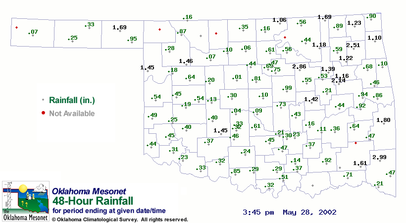
Mesonet Rainfall Illustrates Rain Complications in Eastern Oklahoma

Heavy rainfall at and just upstream from the I-40 disaster site near
Webbers Falls has been causing difficulty since the Sunday morning
barge accident.  Today, unfortunately, is not much different.

The following map shows rainfall since Sunday afternoon:


The rainfall map and the bridge accident highlight the natural link
between weather, climate, hydrology and even emergency services.
Each of these angles plays into the current situation.

Ideally, reservoir operators can assist recovery efforts by impounding
water upstream from the recovery site, thereby reducing streamflow at
the site.  However, the rainfall evident in the above Mesonet map fell
on saturated ground, causing flash-flooding in a few locations in
northeastern Oklahoma.  The reservoir operator must consider a delicate
balance of local flood control, current weather events, recent
rainfall history, and forecast weather events while minimizing
streamflow as much as possible.

This is just a fraction of the big picture, too.  It definitely
underscores the importance of the words "inter-agency cooperation"
we hear so much during events like these.
May 28 in Mesonet History
| Record | Value | Station | Year |
|---|---|---|---|
| Maximum Temperature | 105°F | BEAV | 2022 |
| Minimum Temperature | 39°F | KENT | 2016 |
| Maximum Rainfall | 4.53″ | MANG | 2023 |
Mesonet records begin in 1994.
Search by Date
If you're a bit off, don't worry, because just like horseshoes, “almost” counts on the Ticker website!