Ticker for March 14, 2002
MESONET TICKER ... MESONET TICKER ... MESONET TICKER ... MESONET TICKER ...
March 14, 2002     March 14, 2002     March 14, 2002     March 14, 2002

From OCS Senior Staff Climatologist Mark Shafer:

Conditions have been ripe for an outbreak of wildfires for several days
now.  Heat, wind, and dry air combined to create a dangerous situation
across most of western Oklahoma.  As of Thursday afternoon, the Oklahoma
Climatological Survey reported conditions had not eased substantially,
although some relief is on the way.

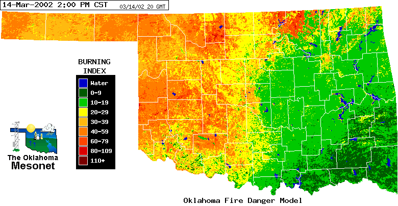
At 2:00 p.m. Thursday, the Oklahoma Fire Danger Model indicated a potential
for flames up to ten feet high and able to cover the length of a football
field in about two minutes:


All except far eastern sections of Oklahoma were under a Red Flag Fire
Alert.  The tiniest of sparks can set off big problems.

The key ingredients contributing to high fire danger conditions are:

Heat ? temperatures climbed into the 90?s in southwestern Oklahoma
on Wednesday and were headed that way for a second consecutive day.
Wind ? winds gusting over thirty miles per hour have been commonplace for
the last two days.  High winds push the flames quickly across
fields and also contribute to the fire?s intensity by mixing
in plenty of oxygen.
Dry air ? afternoon relative humidity dipped below 20 percent in western
Oklahoma, resulting in dry vegetation surfaces.

A cold front progressing southeastward across the state will bring relief
from the heat, but permanent relief is nowhere in sight.  Forecasts indicate
that no rain is likely with the front; that will have to wait until early
next week.

Even with occasional cold fronts and showers, fire danger will likely remain
high for some time.  Much of the state is well below normal in precipitation
this year, and some parts of the state are in a continuing dry spell
stretching back to last summer.  Some areas in western Oklahoma lack much
deep soil moisture, meaning plants will dry out quickly as reserves get
depleted.  Any time heat, wind, and dry air come together, care should be
taken in outdoor activities.  A spark from a passing car, a cigarette
carelessly tossed onto the ground, or a lightning strike can quickly get
things burning.  Fire danger conditions are updated around-the-clock at:

http://agweather.mesonet.org/models/fire.
March 14 in Mesonet History
| Record | Value | Station | Year |
|---|---|---|---|
| Maximum Temperature | 90°F | WAUR | 2002 |
| Minimum Temperature | 10°F | HOOK | 1999 |
| Maximum Rainfall | 2.45″ | BYAR | 2020 |
Mesonet records begin in 1994.
Search by Date
If you're a bit off, don't worry, because just like horseshoes, “almost” counts on the Ticker website!