Ticker for December 4, 2001
MESONET TICKER ... MESONET TICKER ... MESONET TICKER ... MESONET TICKER ...
December 4, 2001   December 4, 2001   December 4, 2001   December 4, 2001


Snowbelt Snowmelt Felt

With afternoon temps basking in the 70s today, let's revisit a much
colder era: last week.  Much of Oklahoma was covered in snow late last
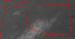
week, and that snow was visible in satellite imagery from midday Friday:


That band of remaining snow from Altus to the south and east sides of
the OKC metro area played a significant role in local weather conditions
Friday.  Take a look at the Mesonet weather map from Friday afternoon:


Temperatures over the snowbelt were in the low-to-mid 50s, about ten
degrees cooler than surrounding areas.  Snowbelt temps were held down
by large differences in diabatic heating relative to the rest of the
state.  The snow's higher albedo reflected more sunlight, and energy
from the sunlight that managed to "stick" went primarily into melting
snow (instead of heating the surface).  The relative humidity field
amplified the contrast within the temperature and dew point fields:


Moreover, winds diverge from the snowbelt, in defiance of a dry line
(or trough, wind shift line, or whatever you'd like to call it) to the
west and north.  This occurred because a mesoscale high pressure
feature evolved as a result of the anomalously cool temperatures.
The contrast between the snowbelt airmass and the airmass behind the
wind shift line showed up in the radar reflectivity images Friday
(that spike to the southwest is the setting sun, by the way):


Finally, much of the snowmelt appearred as "rain" in the Mesonet rain
gauges late last week:

December 4 in Mesonet History
| Record | Value | Station | Year |
|---|---|---|---|
| Maximum Temperature | 83°F | BURN | 2017 |
| Minimum Temperature | -2°F | NOWA | 2006 |
| Maximum Rainfall | 2.44″ | MIAM | 1999 |
Mesonet records begin in 1994.
Search by Date
If you're a bit off, don't worry, because just like horseshoes, “almost” counts on the Ticker website!