Ticker for July 16, 2001
MESONET TICKER ... MESONET TICKER ... MESONET TICKER ... MESONET TICKER ...
July 16, 2001 July 16, 2001 July 16, 2001 July 16, 2001
News Flash: It's Hot and Humid
Heat indices across Oklahoma sit at or near 100 F this afternoon, thanks
to very high temperatures in the south and southwest and very high dew
points in the northeast. As of 3:00 pm, about one-quarter of the
Oklahoma Mesonet's 114 sites observed maximum temps of 100 F or greater.
The greatest high temperature (so far) was Grandfield's 109 F. These
searing surface temps make for uncomfortable or downright dangerous
conditions.
In the north, a different recipe was contributing to discomfort. This
morning, rain fell on the northern third of the state. Amounts of
about one-half inch were typical, but two stations (Nowata and Miami)
observed more than an inch. The summer sun has returned much of this
moisture to the atmosphere through evaporation, raising dew points to
near 80 F in some locations. When there's that much moisture in the
air, perspiration evaporates much more slowly, which means people
cool off much more slowly because their natural temperature control
operates at a lower efficiency.
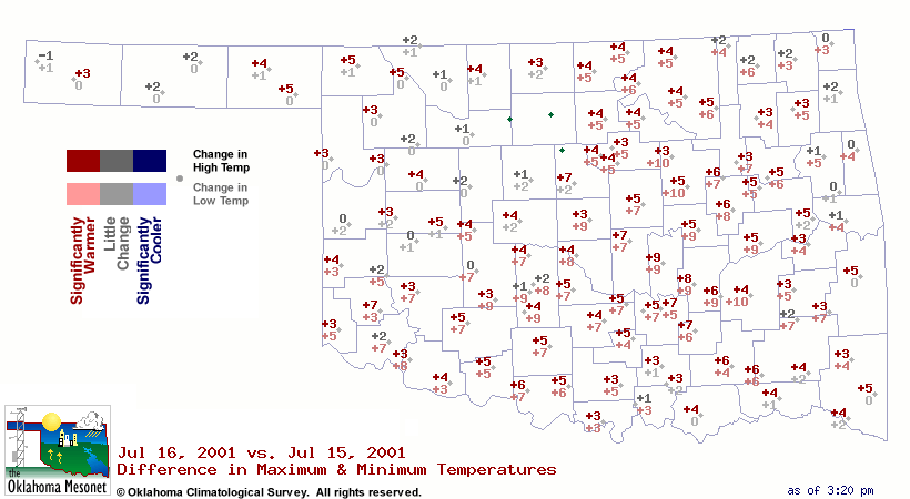
Speaking of efficient climate control, the day's minimum temperature
can be an important indicator of how hard an air conditioner works
during the 24 hours that make up a day. The numbers on the following
map show the difference in today's high/low vs. yesterday's high/low.
Those "+" values for the change in low temperature can have a big
impact on the amount of energy needed to keep buildings comfortable.
July 16 in Mesonet History
| Record | Value | Station | Year |
|---|---|---|---|
| Maximum Temperature | 109°F | HOLL | 2001 |
| Minimum Temperature | 51°F | JAYX | 2014 |
| Maximum Rainfall | 3.82 inches | ALTU | 2014 |
Mesonet records begin in 1994.
Search by Date
If you're a bit off, don't worry, because just like horseshoes, “almost” counts on the Ticker website!