Ticker for March 15, 2001
MESONET TICKER ... MESONET TICKER ... MESONET TICKER ... MESONET TICKER ...
March 15, 2001 March 15, 2001 March 15, 2001 March 15, 2001
Very Strong Winds Rake Oklahoma
On the west side of a very intense surface low, very powerful
straight-line winds scoured (and continue to scour) much of Oklahoma
this afternoon. As of 3:30 pm, 74 observations at 19 different
Mesonet stations exceeded the severe wind threshold (> 57.4 mph)
usually reserved for thunderstorms. At Cheyenne, in far western
Oklahoma, 18 such observations were made, including a stretch of
nine consecutive five-minute periods from 1:45 pm to 2:25 pm.
That surface low showed up extremely well on the 11:15 am Mesonet
surface map:
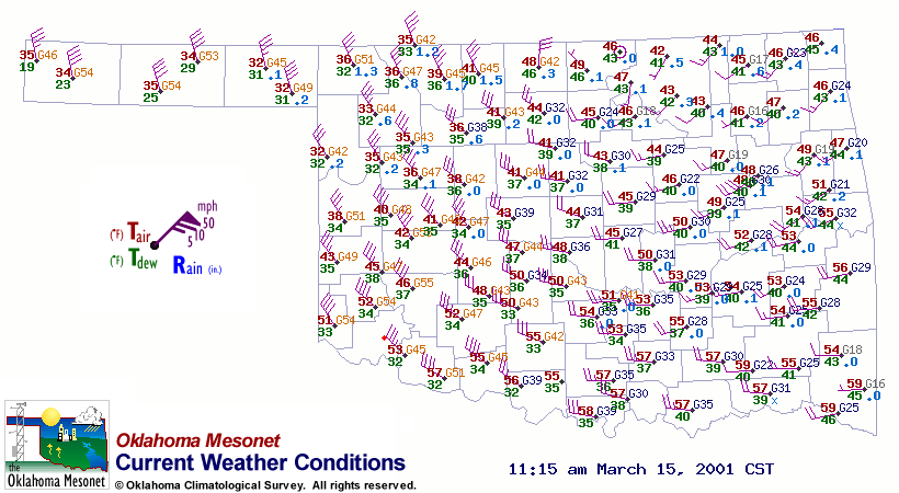
Notice the very strong winds pinwheeling around the calm observation
Newkirk in north central Oklahoma.
Here's a list of some of the last 24 hours' strongest gusts:
Station Gust Time
Medicine Park 64 mph 1:40 pm
Slapout 64 mph 12:30 pm
Butler 63 mph 11:05 am
Butler 62 mph 2:20 pm
Cheyenne 62 mph 2:05 pm
Medicine Park 62 mph 1:35 pm
Seiling 62 mph 11:15 pm
Boise City 62 mph 7:10 pm
Cheyenne 61 mph 2:15 pm
Cheyenne 61 mph 2:00 pm
Cheyenne 61 mph 1:45 pm
Slapout 61 mph 12:50 pm
Buffalo 61 mph 12:45 pm
Mangum 61 mph 12:40 pm
Buffalo 61 mph 12:40 pm
Bessie 61 mph 11:30 am
Boise City 61 mph 11:00 am
Hooker 61 mph 9:55 am
Boise City 61 mph 9:20 am
Seiling 61 mph 11:25 pm
Goodwell 61 mph 7:55 pm
Goodwell 61 mph 7:50 pm
Boise City 61 mph 7:15 pm
March 15 in Mesonet History
| Record | Value | Station | Year |
|---|---|---|---|
| Maximum Temperature | 88°F | ALV2 | 2013 |
| Minimum Temperature | 14°F | SLAP | 1997 |
| Maximum Rainfall | 3.96 inches | WILB | 2014 |
Mesonet records begin in 1994.
Search by Date
If you're a bit off, don't worry, because just like horseshoes, “almost” counts on the Ticker website!