Ticker for February 23, 2001
MESONET TICKER ... MESONET TICKER ... MESONET TICKER ... MESONET TICKER ...
February 23, 2001 February 23, 2001 February 23, 2001 February 23, 2001
(corrected for faulty link)
Heavy Rain Today
Thundershowers and storms are propagating southwest-northeast across
the state today. So far, the greatest rainfall totals have fallen
mainly within an OKC-Tulsa-Stillwater triangle. Here are totals since
midnight, as of 2:30 p.m.:
Red Rock 2.33" Catoosa 1.33" Eufaula 1.28"
Breckinridge 1.62" Hectorville 1.33" Stillwater 1.25"
Watonga 1.49" El Reno 1.29" Claremore 1.25"
Bixby 1.55" Okemah 1.29" Haskell 1.22"
Bowlegs 1.44" Porter 1.29" Okmulgee 1.22"
Five Years Ago in Oklahoma Weather History
It may not seem like it on a cold, rainy day like today, but February
can be a very dangerous month in terms of fire conditions across
Oklahoma. That was painfully apparent five years ago this week, when
wildfires ravaged much of the state, particularly parts of northwest
and north-central Oklahoma.
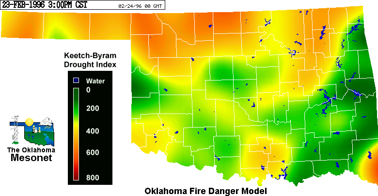
A cold season cold season drought left soil conditions quite dry by
early 1996. This Keetch-Byram Drought Index image from mid-February
shows deficit conditions over much of the state:
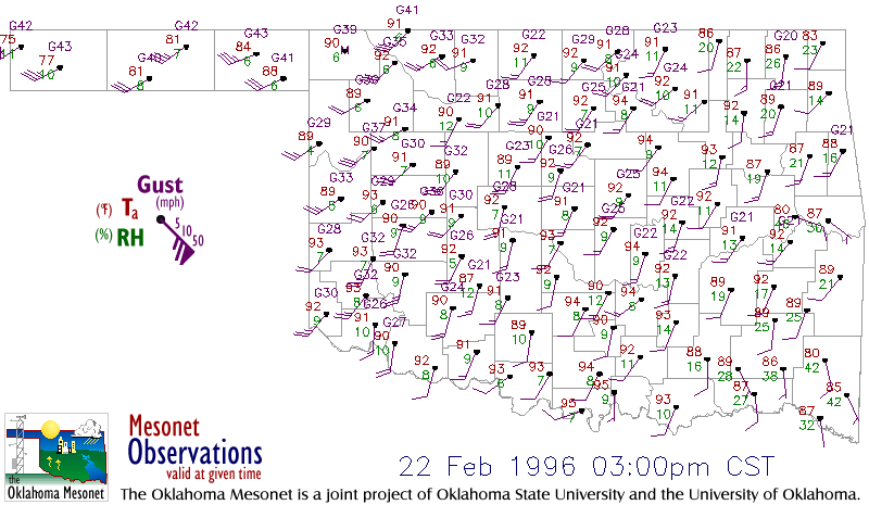
On the 22nd, record highs were set throughout the state. Some stations
recorded high temperatures in the upper 90s. This image from 3:00 p.m.
that afternoon shows temperatures around 90 F, relative humidity values
in the single digits, and winds gusting to more than 30 mph:
Several large and many small fires were started in this environment.
More than 100,000 acres in Woods County burned in the next 48 hours,
90,000 acres in one fire alone. A 40,000-acre fire in Payne County
isolated the city of Stillwater from the rest of the world, as roads
were closed out of town.
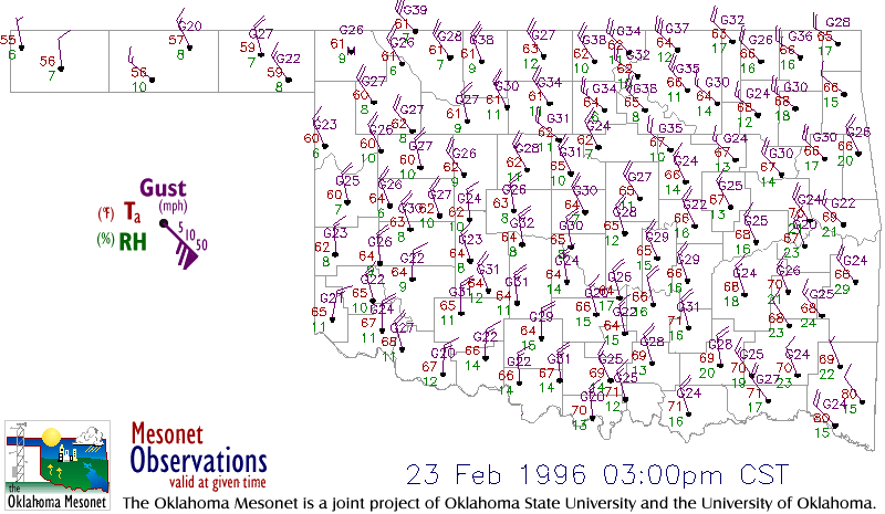
The next day a "cold" front crossed the state, replacing hot, dry and
windy conditions with warm, dry and windy conditions. Moreover, the
winds were now from the northwest, pushing fires in a new direction:
These events only accelerated the work on the Oklahoma Fire Danger
Model, which was already in development. OSU's Dr. J.D. Carlson, who
brought the model to Oklahoma and adapted it to local conditions, and
OCS's Justin Greenfield, who did much of the data-handling and
programming, had the model operational within weeks.
The Feb 22-23 conditions were fed into the model, and remain among the
most extreme fire danger conditions ever calculated by the tool.
Burning Index (BI) values from the two days
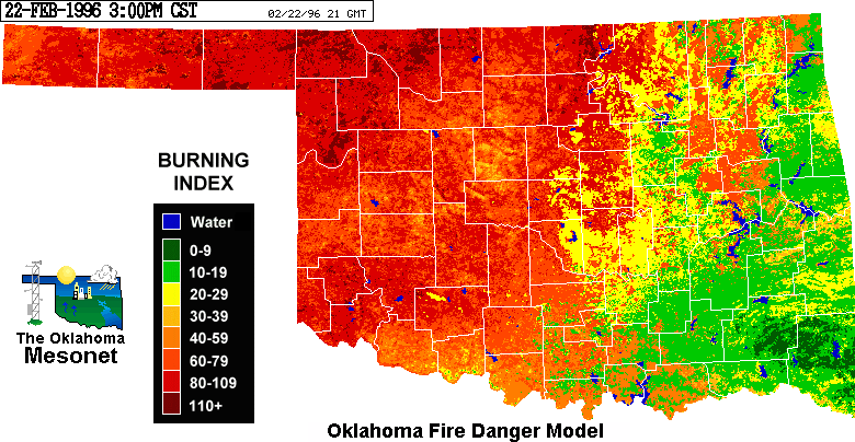
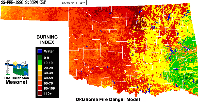
suggest flame lengths
approaching eleven feet at the head of the fire. Spread Component
values from the two days
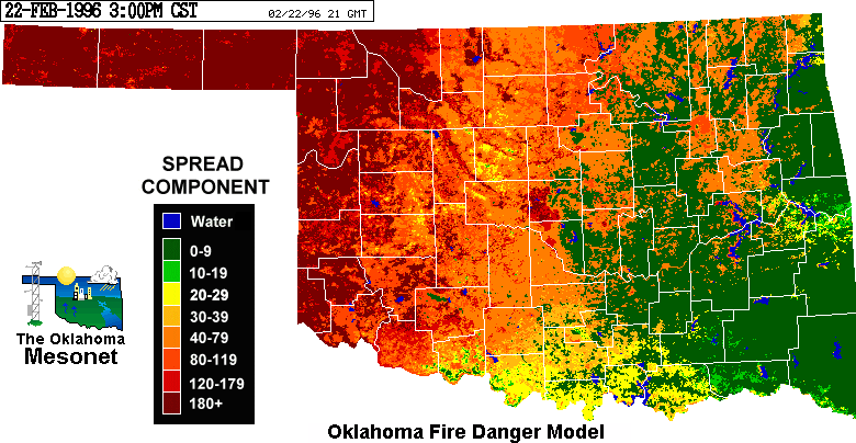
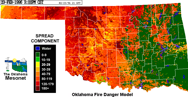
suggest that wildfires propagated at more
than 180 feet per minute. That's more than three feet per second of
advancement!
The Oklahoma Fire Danger Model is updated eleven times per day and is
available on the web at
http://agweather.mesonet.org/
February 23 in Mesonet History
| Record | Value | Station | Year |
|---|---|---|---|
| Maximum Temperature | 91°F | WAUR | 2017 |
| Minimum Temperature | -2°F | BOIS | 2022 |
| Maximum Rainfall | 3.61 inches | EUFA | 2018 |
Mesonet records begin in 1994.
Search by Date
If you're a bit off, don't worry, because just like horseshoes, “almost” counts on the Ticker website!