Ticker for February 9, 2001
MESONET TICKER ... MESONET TICKER ... MESONET TICKER ... MESONET TICKER ...
February 9, 2001 February 9, 2001 February 9, 2001 February 9, 2001
Impressive Cold Front Statistics
A powerful cold front pushed through the state yesterday and today,
bringing much colder temperatures, stiff winds and thunderstorms.
Temperatures dropped very rapidly immediately upon the front's passage.
An illustration of this lies in today's Mesonet high & low temperatures
since midnight:
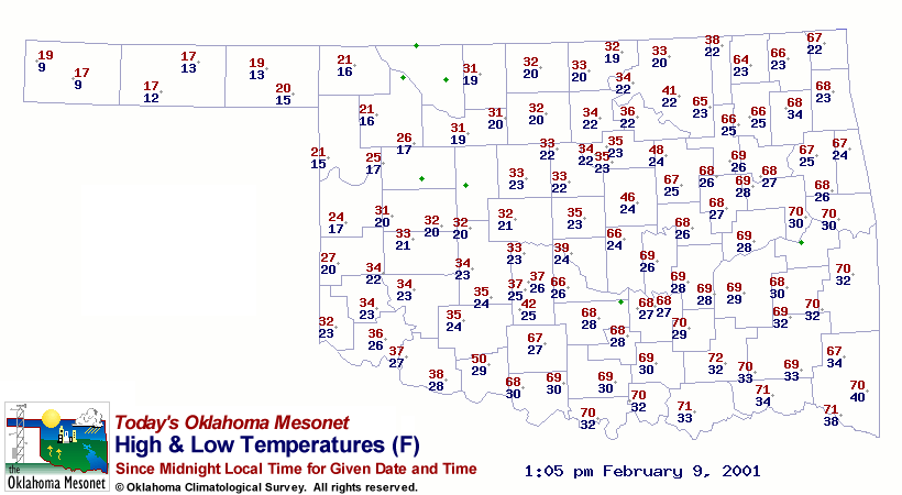
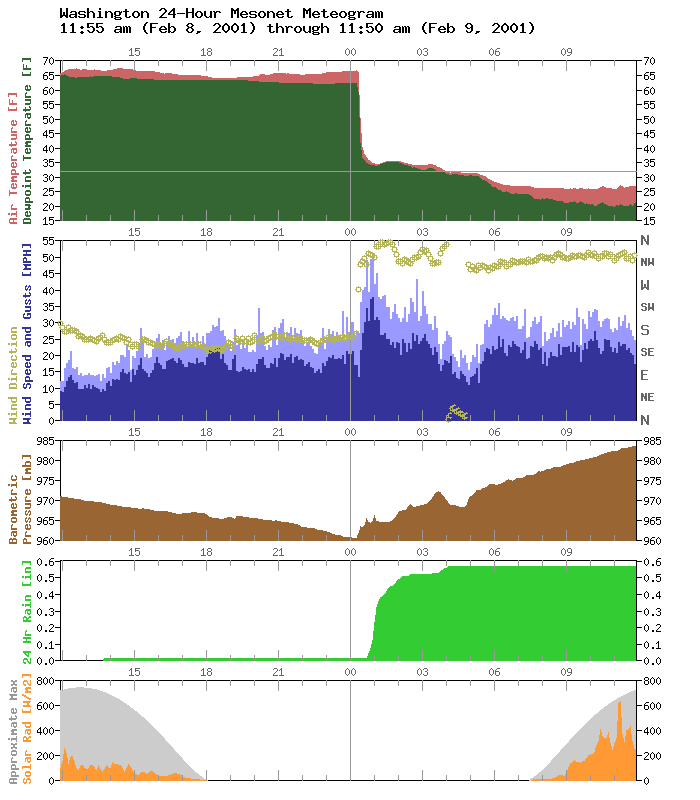
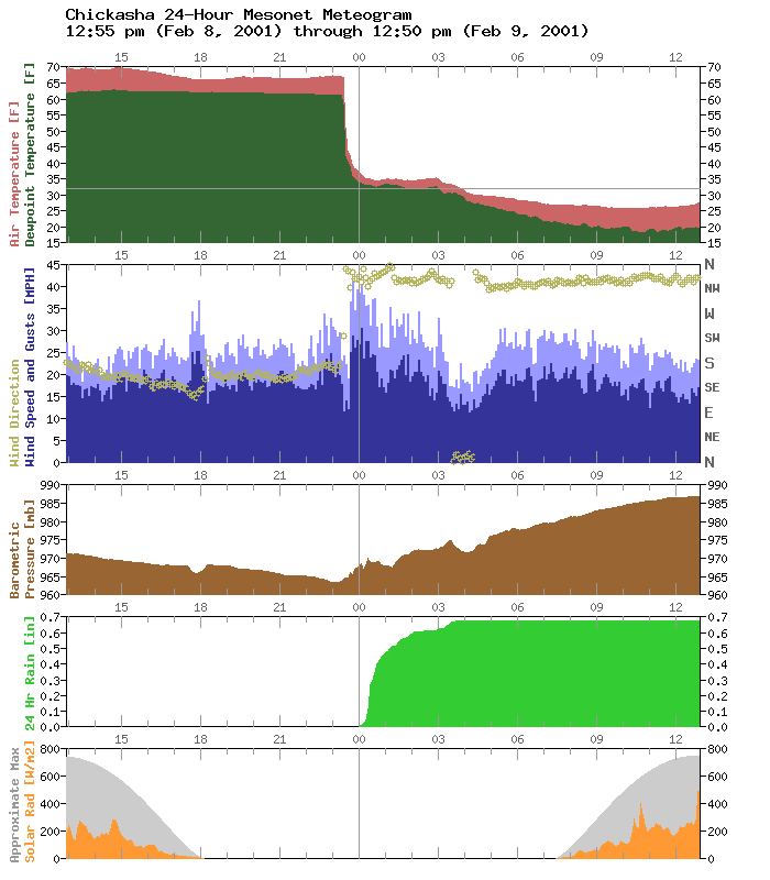
Washington observed a daily maximum of 66 F. The high at Chickasha,
just 20 miles west of the Washington station, is 37 F. This is because
the front passed Chickasha before midnight, and Washington shortly
afterward:
Members of the Mesonet operations group collected one-minute data
(in addition to the usual five-minute obs) for a handful of stations
in Oklahoma and found that the Norman site observed a temperature
drop of 18.7F in just two minutes!
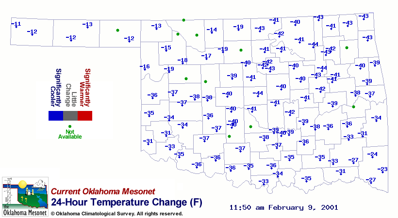
In most of Oklahoma, temps dropped more than 40 degrees behind the
front, which can be seen in the Mesonet 24-hour temperature change
map (the front passed the northwestern part of the state more than
24 hours ago, which accounts for the more modest numbers up there):
Some "Top Ten" Lists from the Event
15-min Temp Drops 5-min Temp Drops Strongest Wind Gusts
Ketchum Ranch -29 F Pauls Valley -19 F Medicine Park 68 mph 11:30p
Ninnekah -29 F Bowlegs -17 F Grandfield 67 mph 11:30p
Pauls Valley -29 F Acme -15 F Ketchum Ranch 64 mph 12:40a
Acme -28 F Grandfield -15 F Medicine Park 62 mph 11:45p
Washington -28 F Minco -15 F Walters 61 mph 12:00a
Bowlegs -27 F Ninnekah -15 F Okemah 58 mph 1:55a
Medicine Park -27 F Chickasha -16 F Medicine Park 58 mph 11:50p
Okemah -27 F Ketchum Ranch -16 F Medicine Park 58 mph 11:40p
Grandfield -26 F Vanoss -16 F Lane 57 mph 3:10a
Vanoss -26 F Washington -16 F Pauls Valley 57 mph 1:10a
A Note from the Mesonet QA Manager
Several stations in the panhandle and extreme northwestern Oklahoma
took on freezing precipitation overnight. When this accumulates on
wind monitors, the resulting wind observations can be significantly
depressed or even brought to zero. Therefore, some Mesonet wind
values in extreme northwestern Oklahoma will be reported as "missing"
until the ice melts and the observations return to normal.
February 9 in Mesonet History
| Record | Value | Station | Year |
|---|---|---|---|
| Maximum Temperature | 82°F | GRA2 | 2000 |
| Minimum Temperature | -18°F | MEDF | 2011 |
| Maximum Rainfall | 1.02 inches | VINI | 2001 |
Mesonet records begin in 1994.
Search by Date
If you're a bit off, don't worry, because just like horseshoes, “almost” counts on the Ticker website!