Ticker for December 13, 2000
MESONET TICKER ... MESONET TICKER ... MESONET TICKER ... MESONET TICKER ...
December 13, 2000 December 13, 2000 December 13, 2000 December 13, 2000
Lots of Good Meteorology in a Meteogram
One meteogram can tell a handful of stories. Take, for example, the
most recent Mesonet meteogram for Stigler, in eastern Oklahoma:
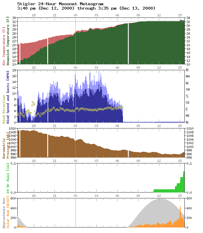
As with all Mesonet meteograms, the traces represent the evolution of
meteorological conditions in the last 24 hours (from left to right on
your screen). At Stigler, three events are fairly apparent and one is
a bit mysterious:
1. A "moistening up" of the lower atmosphere.
The top panel displays the air temperature (pink) and the dew point
temperature (green). At roughly 3:30 pm yesterday (the left side
of the graphic) the air was very cold and quite dry. As the
evening progressed, the atmosphere warmed slightly and moistened
substantially, as the convergence of the dew point trace and air
temperature trace shows. At the time, nearby National Weather
Service observations reported light freezing rain or light freezing
mist. As this moisture was introduced to the lower atmosphere, the
humidity increased rapidly.
2. Freezing of the wind monitor.
The second panel shows wind speed (blue) and wind gusts (light
blue) for every five minutes. As the precipitation continued into
the morning hours, the wind speed decreased slowly but noticably.
This gradual decrease continued until about 7:00 am, when observed
wind speeds suddenly went to zero. This is the time when the
propeller of the Mesonet prop-vane was overwhelmed by the
accumulation of ice, and was no longer able to turn.
3. Melting of some frozen precipitation.
In the afternoon hours of the 13th (the rightmost observations on
the graphic), the rain gauge recorded some precipitation, displayed
as the escalating green bars in the fourth panel. The bottom panel
(solar radiation) also shows a strange spike at about that time.
These two pieces of evidence, plus the temperature trace, suggest
the melting of freezing/frozen precipitation which fell into the
gauge hours beforehand. Notice that the temperature trace climbed
above the freezing line at the time the precipitation was observed.
3b. What about that spike?
There's a strong possibility that the melting process caused ambient
light to be reflected into the sensor, in addition to the normally
observed light. (Think about holding a piece of typing paper [snow]
or a mirror [ice] next to one of your eyes while looking around the
room. It would reflect more light into that eye.)
Similar events occurred at several Mesonet stations in the region:
https://content.mesonet.org/ticker/archive/20001213/
December 13 in Mesonet History
| Record | Value | Station | Year |
|---|---|---|---|
| Maximum Temperature | 76°F | SLAP | 2021 |
| Minimum Temperature | 3°F | MEDF | 2000 |
| Maximum Rainfall | 4.06 inches | BROK | 2015 |
Mesonet records begin in 1994.
Search by Date
If you're a bit off, don't worry, because just like horseshoes, “almost” counts on the Ticker website!