Ticker for October 11, 2000
MESONET TICKER ... MESONET TICKER ... MESONET TICKER ... MESONET TICKER ...
October 11, 2000 October 11, 2000 October 11, 2000 October 11, 2000
The Benefits of a Mesoscale Network
The difference in scale of observations can make a significant
difference in conclusions drawn from those observations. Here are
two maps of Keetch-Byram Drought Index (KBDI), derived from two
different data source:
National Map: 
Oklahoma Map: 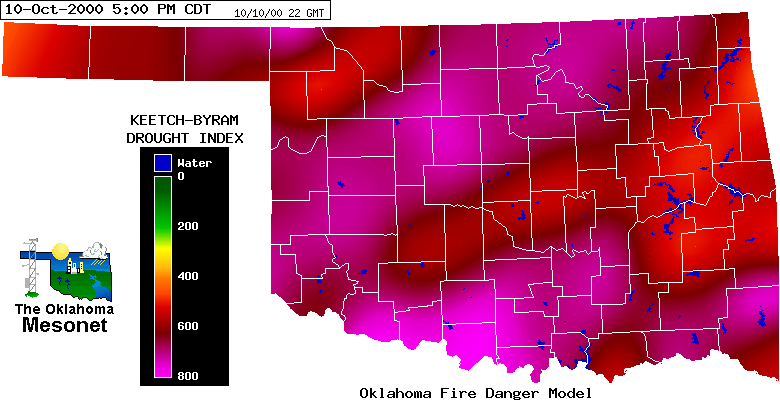
The KBDI can range from 0-800, with 0 indicating complete saturation
of the top eight inches of soil. KBDI values above 400 are associated
with drought and escalated fire danger, and KBDI values above 600 are
associated with extreme drought.
The national map is based on observations from USDA Forestry Service
stations, which report once per day. There about twenty such stations
in all of Oklahoma, Arkansas, Kansas, north Texas and southwest
Missouri. Three of these stations are within Oklahoma.
On the other hand, the state map (a product of the Oklahoma Fire Danger
Model) is based on Oklahoma Mesonet data. There are 114 operational
Mesonet stations in the state, which record data every five minutes.
The higher resolution of the Oklahoma Mesonet observations is apparent
when comparing the maps. The Oklahoma map shows detail that is washed
out by the coarse resolution of the national network. Where the
federal map shows a gradual west-to-east increase from values in the
200s to the 500s across Oklahoma, the Mesonet-based map shows values
greater than 400 statewide and values greater than 600 over two-thirds
of the state.
The national KDBI product is currently used by federal decision makers
when appropriating drought relief funds. Historically, monetary drought
assistance is not awarded until the drought reaches "extreme" conditions.
Although the Mesonet KBDI indicates extreme drought conditions over
almost all of Oklahoma, The National Drought Summary currently reads:
"Severe drought has expanded northward across almost all of eastern
Oklahoma and across much of eastern Kansas. Areas of extreme drought
conditions still exist across the lower Mississippi Valley."
Notice the high correlation of the National Drought Summary and the
national KBDI product. Many Oklahoma lawmakers are concerned that
Oklahoma will not get its fair share of drought assistance funds from
the federal government. Therefore, the Oklahoma Mesonet may play a
pivotal role in proving to federal decision makers the need for
substantial federal drought assistance to Oklahoma farmers and
ranchers.
This message is intended to demonstrate the benefit of the state's
mesoscale observing system in presenting a detailed depiction of
conditions across the state. Because of the limitations of the federal
network, important details may be lacking in the national drought
assessment. These details may be critical to decision-makers in
Washington, D.C. who will deal with the aftermath of this drought.
October 11 in Mesonet History
| Record | Value | Station | Year |
|---|---|---|---|
| Maximum Temperature | 102°F | GRA2 | 2020 |
| Minimum Temperature | 12°F | KENT | 2019 |
| Maximum Rainfall | 1.96 inches | WYNO | 2004 |
Mesonet records begin in 1994.
Search by Date
If you're a bit off, don't worry, because just like horseshoes, “almost” counts on the Ticker website!