Ticker for September 19, 2000
MESONET TICKER ... MESONET TICKER ... MESONET TICKER ... MESONET TICKER ...
September 19, 2000 September 19, 2000 September 19, 2000 September 19, 2000
SPECIAL EDITION ... SPECIAL EDITION ... SPECIAL EDITION ... SPECIAL EDITION
Extreme Fire Danger Continues
The latest (as of 7:00 pm CDT) runs of the Oklahoma Fire Danger Model
continue to indicate extremely hazardous fire danger conditions for the
vast majority of the state of Oklahoma, and several large wildfires
have broken out in central Oklahoma. Soil moisture conditions brought
on by prolonged lack of rainfall continue to exacerbate the situation.
Atmospheric Conditions:
Warm, dry, and gusty conditions observed by the Oklahoma Mesonet indicate
extremely low values for one-hour dead fuel moisture:

This means that
dead and/or dormant grasses and leaves, plus litter and paper, have
little to no moisture content whatsoever.
Due largely to dead-fuel moisture conditions, the likelihood of fire
ignition continues at hazardous levels:
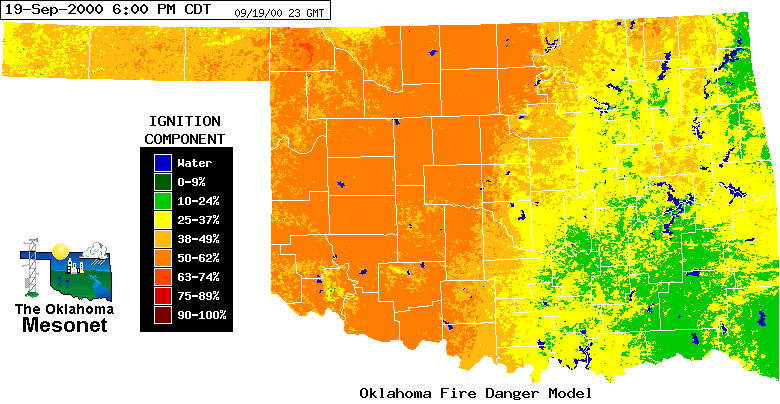
This component is an indicator
of the likelihood (in percent) of a reportable wildfire resulting from
the introduction of just one standard firebrand.
Windy, dry conditions also support a very large spread component
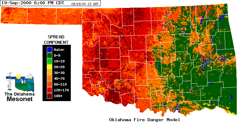
which is an estimate of the rate of spread (in feet per minute) of the
headfire.
Soil Moisture Conditions:
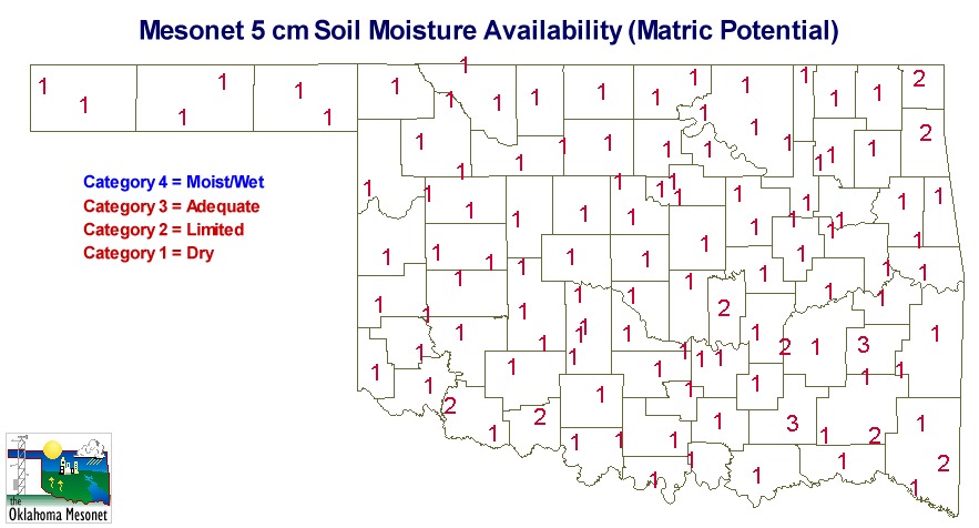
Soil conditions are also very dry over most of the state, as significant
rainfall has not occurred in nearly two months. Mesonet soil moisture
sensors at 5 cm depth indicate soil moisture is in the driest category
measured for more than 90% of the the state:
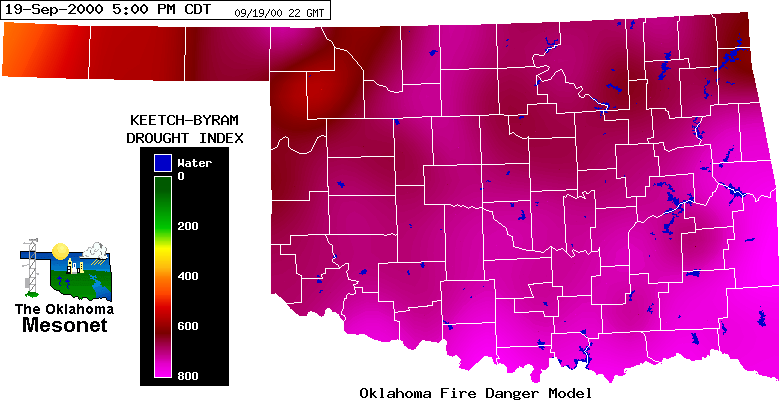
The Mesonet-derived Keetch-Byram Drought Index (KBDI) shows "severe
drought" (values larger than 600) for the upper eight inches of soil for
all but extreme northwest Oklahoma:
Potential Future Conditions:
An advancing cold front and associated wind shift may complicate matters
for decision-makers with personnel and assets in the field. This
afternoon, the front was positioned north of the Oklahoma-Kansas border
and had advanced into extreme northwestern Oklahoma by 7:00 pm. If the
front continues to advance as forecast tonight and tomorrow, a surface
wind shift to more northerly directions will accompany its passage.
Resources:
Forecasts for central and western Oklahoma can be found via NWS Norman:
http://www.srh.noaa.gov/oun/
Forecasts for eastern Oklahoma can be found via NWS Tulsa:
http://www.srh.noaa.gov/tulsa/
Forecasts for the Oklahoma panhandle can be found via NWS Amarillo:
http://www.srh.noaa.gov/ama/
As always, Oklahoma Fire Danger Model output and related Oklahoma fire
weather information can be found via the Oklahoma Mesonet AgWeather
Home Page:
http://agweather.mesonet.org/agwx.html
The Fire Danger Model can be accessed directly at:
http://agweather.mesonet.org/fire/data.html
September 19 in Mesonet History
| Record | Value | Station | Year |
|---|---|---|---|
| Maximum Temperature | 105°F | SEIL | 2024 |
| Minimum Temperature | 33°F | BEAV | 2003 |
| Maximum Rainfall | 4.19 inches | BBOW | 2002 |
Mesonet records begin in 1994.
Search by Date
If you're a bit off, don't worry, because just like horseshoes, “almost” counts on the Ticker website!