Ticker for July 3, 2000
MESONET TICKER ... MESONET TICKER ... MESONET TICKER ... MESONET TICKER ...
July 3, 2000 July 3, 2000 July 3, 2000 July 3, 2000
Mesonet Soil Moisture Sensors Provide Unique Insight
For more than six years now, the Oklahoma Mesonet has operated as a
unique fully-automated environmental observing network. When the
network was first commissioned, a typical Mesonet station observed up
to thirteen atmospheric parameters and up to five different
characteristic soil temperatures.
Since then, the observational capacity of the Oklahoma Mesonet evolved
to include more parameters that help describe the exchange of energy
between the Earth's surface and its atmosphere.
One category of such parameters is soil moisture. With the majority of
its 110-plus sites measuring soil moisture conditions at up to four
standard depths, the Oklahoma Mesonet represents the only automated soil
moisture observing network of its kind in size and scope.
While much of its potential remains to be tapped, the volume of soil
moisture observations already provides a unique eyepiece to the
underground processes of the hydrologic cycle.
Early Summer 2000 vs. Early Summer 1998
Take, for example, a comparison of conditions during this May and June
with the two same months in 1998. After a dry May of 2000, it was noted
in the June 2, 2000 Ticker that rainfall accumulation patterns looked
similar to those of May 1998, at the onset of the catastrophic drought
of summer 1998.
Departure from Normal Rainfall [inches]:
May 1998: 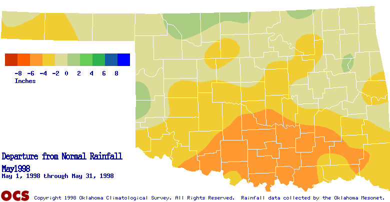
May 2000: 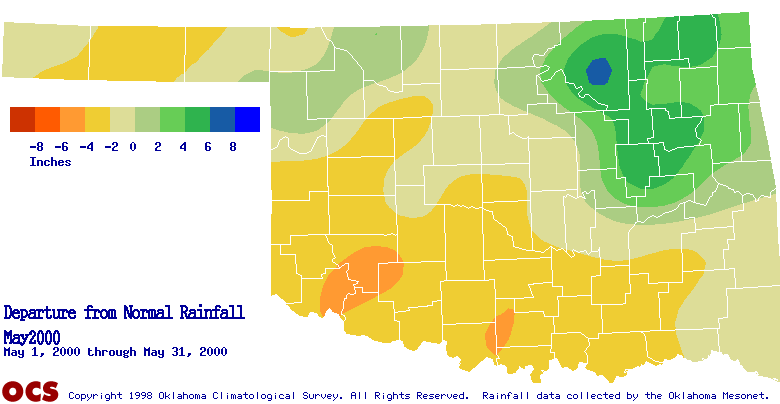
However, a reversal of fortune during June of 2000 meant drastically
differing rainfall patterns between the two years.
Departure from Normal Rainfall [inches]:
June 1998: 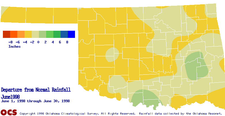
June 2000: 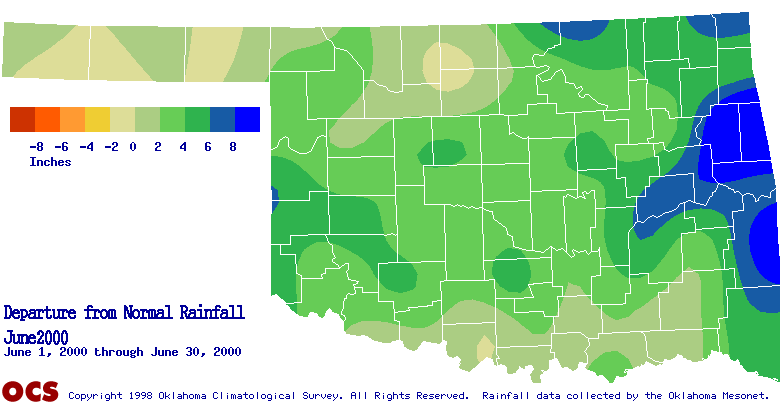
The following statewide maps illustrate the evolution of available soil
moisture conditions over May and June of the two years. The value
displayed is a category assignment, based on the matric potential at a
depth of 25 cm (about 10 inches, around root depth for some crops and
plants). Smaller numbers indicate more moist conditions, while larger
numbers (up to a maximum/extreme of six) indicate drier conditions.
Matric Potential Maps:
5/1/98: 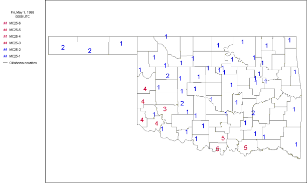
6/1/98: 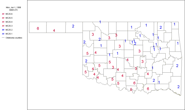
6/30/98: 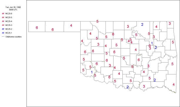
5/1/00: 
6/1/00: 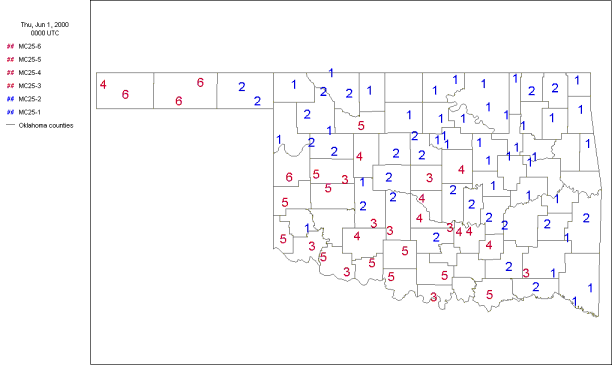
6/30/00: 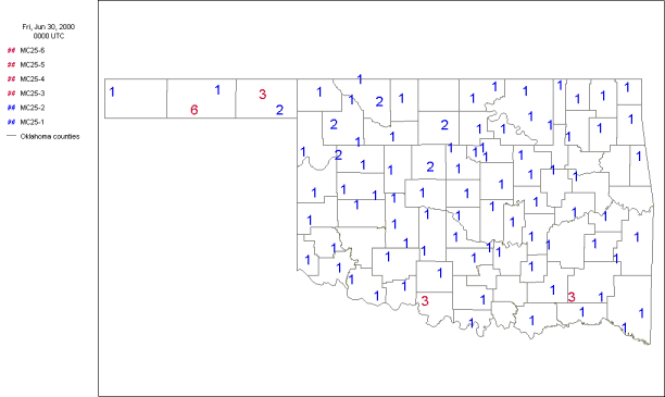
Soil moisture conditions dried at 25 cm during May of both years, as
evidenced by the general decrease in category number from the May 1 to
June 1 maps. However, the June observations were quite different from
1998 to 2000. As one might expect from looking at the above rainfall
maps, extremely dry soil moisture conditions evolved in the western
two-thirds of the state during June 1998, while moist conditions were
commonplace throughout the state by the end of June 2000.
Another Viewpoint: The Time Trace
Another useful application of Mesonet soil moisture data is the
presentation of soil moisture data over time at a single site. While
each site has a unique soil profile and an equally unique response to
rainfall and the lack of rainfall, it is interesting to look at the
contrast of the evolution of conditions between 1998 and 2000.
The following graphics show two month [May-June] traces of volumetric
water content at four depths. In these graphs, and all that follow,
the light green trace represents the 5 cm depth; red 25 cm; blue 60 cm;
and black 75 cm. Larger values [toward the top of the graphic] sugggest
wetter conditions, and smaller values [toward the bottom axis] suggest
drier conditions.
Broken Bow:
At Broken Bow, soil moisture decreased at all four depths during May
of 1998 until being temporarily recharged near the end of the month.
During the very hot and dry June of 1998, all four depths dried
quickly. In contrast, during the same two months of 2000, soil
moisture at all four depths hovered at or near its saturation value.
May-Jun 1998: 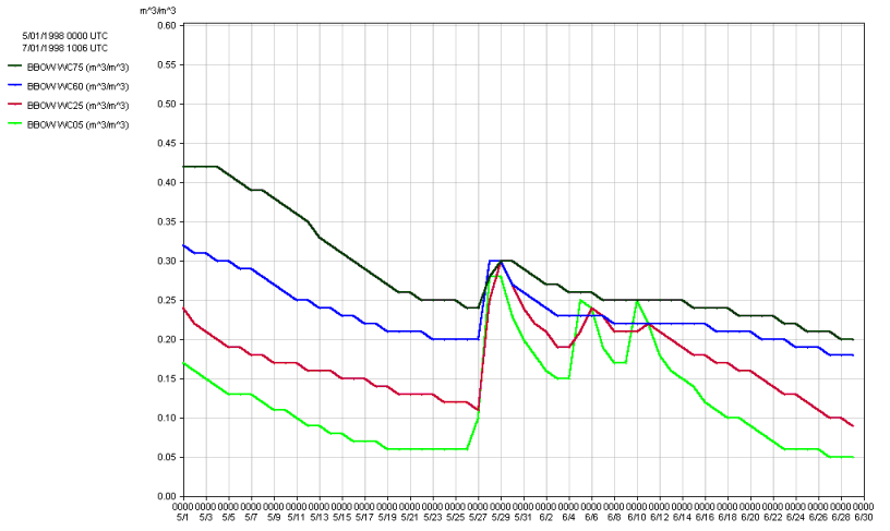
May-Jun 2000: 
Wister:
At nearby Wister, a similar pattern develops for the May-June 1998
period, except that the 1998 period shows that the 5 cm volumetric
water content was recharged by three rainfall events, while the three
deeper levels continued to dry. This suggests that the rainfall
events were not significant enough to effectively percolate to the
deeper levels. However, in 2000, shortly after a drying trend
emerged in late May, the deeper levels were recharged by a
significant rainfall event on June 3rd.
May-Jun 1998: 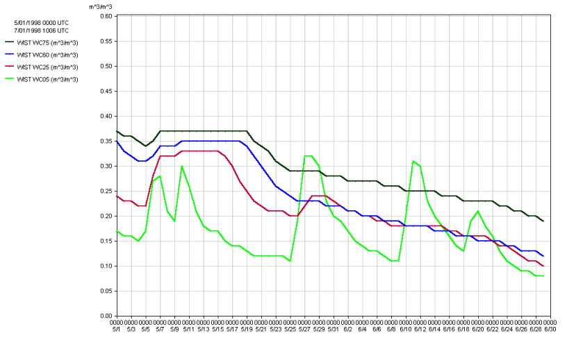
May-Jun 2000: 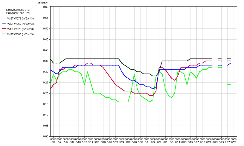
Westville:
The volumetric water content traces from Westville depict a response
at a site characterized by more porous soil. The traces undergo more
rapid drying and quicker recovery in response to rainfall events, as
rainwater passes more quickly through the soils at the site. The
amplitude of the pattern is also much larger.
May-Jun 1998: 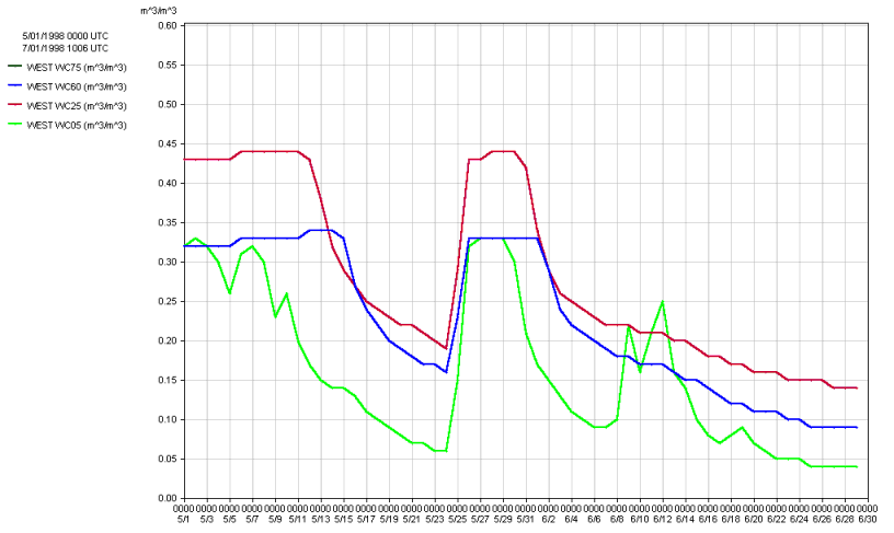
May-Jun 2000: 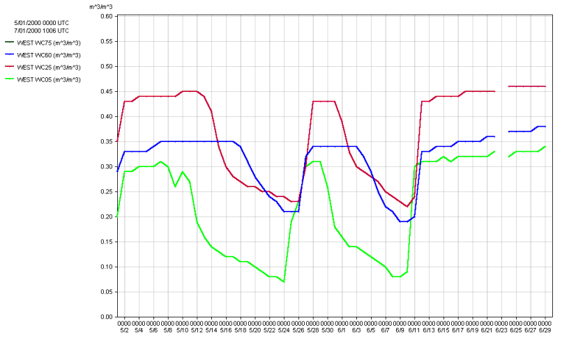
It's a lot to digest, but there's a wealth of information in the
Mesonet's newest suite of tools. The Ticker looks forward to many
happy hydrologic events to come!
July 3 in Mesonet History
| Record | Value | Station | Year |
|---|---|---|---|
| Maximum Temperature | 106°F | KIN2 | 2011 |
| Minimum Temperature | 49°F | VINI | 2014 |
| Maximum Rainfall | 6.39 inches | NOWA | 2016 |
Mesonet records begin in 1994.
Search by Date
If you're a bit off, don't worry, because just like horseshoes, “almost” counts on the Ticker website!