Ticker for June 2, 2000
MESONET TICKER ... MESONET TICKER ... MESONET TICKER ... MESONET TICKER ...
June 2, 2000 June 2, 2000 June 2, 2000 June 2, 2000
Shades of 1998?
Don't look now, but the precipitation patterns from the climatological
spring (March through May) look an awful lot like the springtime
patterns that preceded the summer drought and heatwave of 1998.
Even on a month-by-month basis, the patterns look remarkably similar.
Here's the key to the following contour maps:
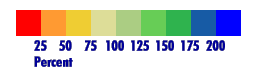
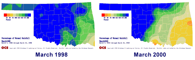
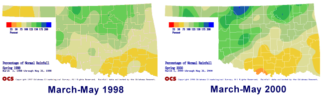
Precipitation from March 1998 and March 2000 were very similar. Western
and northern Oklahoma received well above normal rainfall both years,
which faded into normal and below-normal values in the southeast.
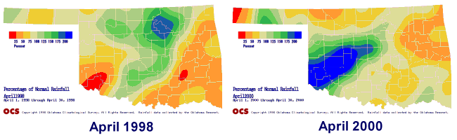
April of the two years was somewhat similar. The majority of the state
observed below-normal precipitation, interrupted by a southwest-to-
northeast belt of normal and above-normal values. The extrema within
the swath differ, though. In 1998, the maximum "wet" area was in
north-central Oklahoma, while in 2000, the maximum was shifted to the
southwest.
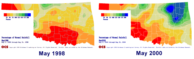
The precipitation patterns from May 2000 were very similar to those of
May 1998. Most of western, central and sourthern Oklahoma received
well below normal rainfall, with an area of normal or above normal
rainfall in the northeast. In 2000, this area was more pronounced.
When the three-month spring season is taken as a whole, the patterns
are eerily similar. North central and northwest Oklahoma showed above
normal values for the season, while the southern counties recorded
below normal precipitation.
The summer of 1998 brought record heat and costly drought to most of
Oklahoma. Hopefully, this summer won't match the summer of 1998 as
closely as the spring season mapped spring of 1998.
One final fact about the summer of 1998: it saw a state record wheat
harvest. The rain stopped just in time for the curing and harvest of
the crop.
Today in Oklahoma Weather History
Drought and heatwave weren't the only calamities that came to Oklahoma
during the summer of 1998. On June 2, 1998 the first issue of the
Ticker was inflicted on a handful of unfortunate souls. Since then,
the distribution list has grown to one hundred, the message archive
takes up more than a megabyte, and we've used the word "eerily" at
least once.
The Ticker staff is thankful for all of the suggestions and feedback.
And we'll make this promise:
For the next year, you can expect from the Ticker all of the
wit, charm, spelling and clarity of any other two year old.
Thanks for two fun years!
June 2 in Mesonet History
| Record | Value | Station | Year |
|---|---|---|---|
| Maximum Temperature | 111°F | MANG | 1998 |
| Minimum Temperature | 42°F | HOOK | 2013 |
| Maximum Rainfall | 5.14 inches | WYNO | 2014 |
Mesonet records begin in 1994.
Search by Date
If you're a bit off, don't worry, because just like horseshoes, “almost” counts on the Ticker website!