Ticker for February 16, 2000
MESONET TICKER ... MESONET TICKER ... MESONET TICKER ... MESONET TICKER ...
February 16, 2000 February 16, 2000 February 16, 2000 February 16, 2000
*** CORRECTED FOR BAD LINK! ***
That was a cold front, right?
During the overnight hours, a fairly significant cold front passed
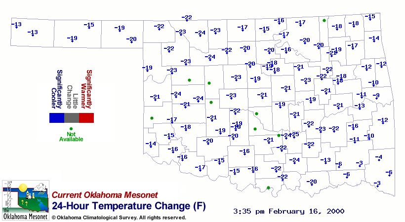
through Oklahoma. After all, today's temperatures are much cooler
than yesterday's afternoon temps:
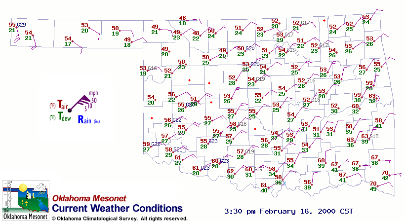
The wind field in Oklahoma right now certainly suggests a frontal
passage:
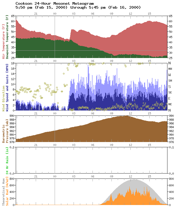
So, what's up with the temperature jumping ten degrees *warmer* at
2:30 in the morning at Cookson?
It's an example of a few things:
1. Just how much turbulence can affect overnight temps, and
2. Just how shallow a cold front can be
The Ticker has documented several cases of how minimum temps are
affected by the turbulent mixing of relatively warmer air from layers
above the surface:
https://content.mesonet.org/ticker/archive/tickselect.cgi?mo=8&da=26&yr=1999
https://content.mesonet.org/ticker/archive/tickselect.cgi?mo=9&da=9&yr=1999
Last night's meteogram from Cookson shows that even after the winds
had shifted to the north at the surface, the turbulent mixing was drawing
warmer air from above. The position of the Cookson station relative to
the front with time is shown in the following cartoon (thanks to the guys
in the Ticker graphics department for putting in overtime):

Instead of a blast of cold air, the Mesonet station was treated with a
blast of well-mixed air. Because fronts are shallow by nature, the very
thin layer of cold air was no match for the warmer air just aloft.
As the surface front dove southward, and the the cold layer at the
station became deeper, this "warming" effect lessened. With time, the
turbulent mixing was progressively contained within the cold layer, so
the temperature steadily dropped.
Just another example of the meteorological joys that can be found in
a meteogram.
February 16 in Mesonet History
| Record | Value | Station | Year |
|---|---|---|---|
| Maximum Temperature | 85°F | HOLL | 2011 |
| Minimum Temperature | -22°F | NOWA | 2021 |
| Maximum Rainfall | 3.37 inches | TALI | 2008 |
Mesonet records begin in 1994.
Search by Date
If you're a bit off, don't worry, because just like horseshoes, “almost” counts on the Ticker website!