Ticker for August 27, 1999
MESONET TICKER ... MESONET TICKER ... MESONET TICKER ... MESONET TICKER ...
August 27, 1999 August 27, 1999 August 27, 1999 August 27, 1999
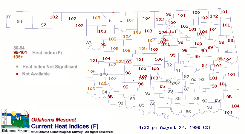
Some Neat Effects from Today's Convective Action
Rain-cooled in south-central Oklahoma has provided the area
with a welcome break from the August heat. One look at the
heat index map illustrates this nicely:
Convection in western Oklahoma is co-located with a developing
meso-low that is seen in the 4:30 pm weather map:
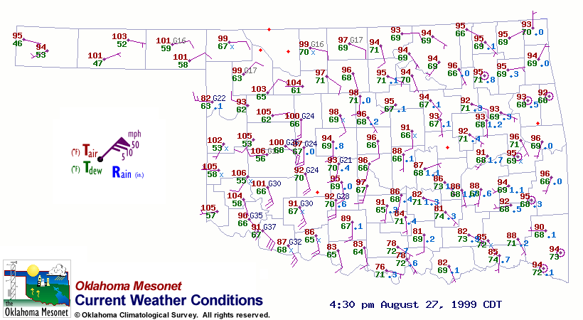
Notice the very strong southerly wind gusts west of Interstate 35
in southern Oklahoma. What are they? The cool temperatures suggest
that they are outflow from storms in north-central Texas. However,
the southerly component has been enhanced by the mesolow in
west-central Oklahoma.
Strongest Wind Gusts in the Last 24 Hours
Station Gusts Date Time
Arnett 52 mph Aug 27 3:55 pm
Acme 57 mph Aug 27 1:00 am
Acme 73 mph Aug 27 12:55 am
Acme 81 mph Aug 27 12:50 am
Byars 67 mph Aug 26 10:35 pm
Pawnee 53 mph Aug 26 7:55 pm
Putnam 57 mph Aug 26 7:45 pm
Putnam 53 mph Aug 26 7:40 pm
Jay 50 mph Aug 26 6:55 pm
August 27 in Mesonet History
| Record | Value | Station | Year |
|---|---|---|---|
| Maximum Temperature | 109°F | GRA2 | 2011 |
| Minimum Temperature | 48°F | SEIL | 2010 |
| Maximum Rainfall | 3.95 inches | CLOU | 1996 |
Mesonet records begin in 1994.
Search by Date
If you're a bit off, don't worry, because just like horseshoes, “almost” counts on the Ticker website!