Ticker for August 24, 1999
MESONET TICKER ... MESONET TICKER ... MESONET TICKER ... MESONET TICKER ...
August 24, 1999 August 24, 1999 August 24, 1999 August 24, 1999
Please Do Not Adjust Your Set ...
Due to an telecommunications network interruption, several state
agencies and the Oklahoma Mesonet are having communication problems
today. Service will be restored shortly. As a result, though, only
Mesonet stations that can broadcast their signal directly to the
antennas on the Norman campus are reporting.
Two very interesting meteograms today ...
Meteograms can cram a lot of meteorology into a compact graphic.
The last day has demonstrated that nicely.
The Haskell meteogram from this morning shows the immediate impact
of an evening thunderstorm:
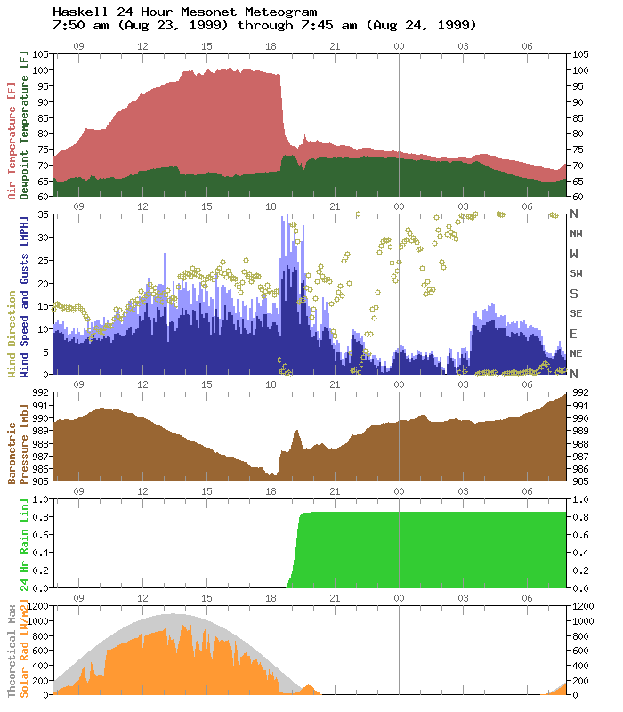
The temperature at the station dropped more than 20 degrees in a
half-hour as almost an inch of rain fell. Notice the nice pressure
spike and wind burst with the onset of rainfall.
Speaking of wind and pressure, look at the early morning hours
of today's Norman sounding:
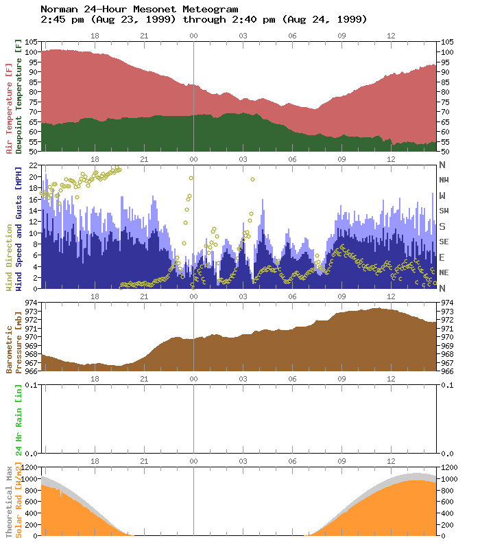
Six or seven subtle pressure wavelets are accompanied by more obvious
oscillations in the wind field. This seems to be the same phenomenon
noticed more often in wintertime Mesonet meteograms (Ticker reference:
https://content.mesonet.org/ticker/archive/tickselect.cgi?mo=07&da=12&yr=1999 )
Just as the case on the morning of July 12th at Waurika, the Norman
meteogram was observing air to the north of a cold frontal zone.
This further indicates that this "wobbling" or "sloshing" phenomenon
is indeed closely related to shallow surface layers.
Time to break out those old shallow wave theory notes!
August 24 in Mesonet History
| Record | Value | Station | Year |
|---|---|---|---|
| Maximum Temperature | 113°F | FREE | 2024 |
| Minimum Temperature | 52°F | EVAX | 2022 |
| Maximum Rainfall | 4.59 inches | SHAW | 2010 |
Mesonet records begin in 1994.
Search by Date
If you're a bit off, don't worry, because just like horseshoes, “almost” counts on the Ticker website!