Ticker for July 23, 1999
MESONET TICKER ... MESONET TICKER ... MESONET TICKER ... MESONET TICKER ...
July 23, 1999 July 23, 1999 July 23, 1999 July 23, 1999
Hottest Day Yet
As of 4:15 pm, 98 of the 115 Oklahoma Mesonet stations reported
high temperatures which met or exceeded their previous maximums for
the year. Only stations in the panhandle and most of southwestern
Oklahoma have escaped setting their 1999 marks today. 25 Mesonet
stations are reporting high temps at or above 100 F.
Today's high temperatures are updated every 15 minutes at:

Fire Season Waking Up, plus Dramatic 7-Day KDBI Change
The state forestry division has tracked 18 fires since July 15th east
of U.S. Hwy 69. This isn't a large number for July, but it does
indicate that the summer fire season is beginning, according to
Forestry Division assistant director Pat McDowell.
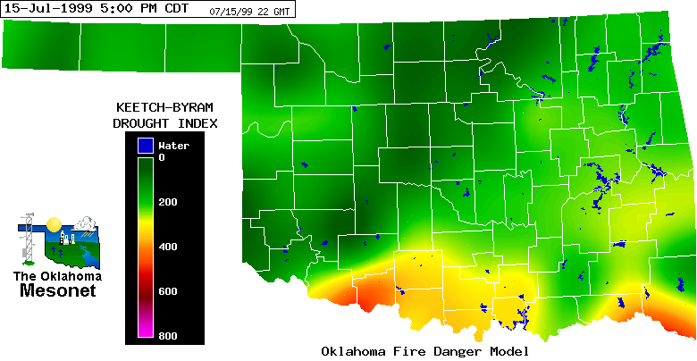
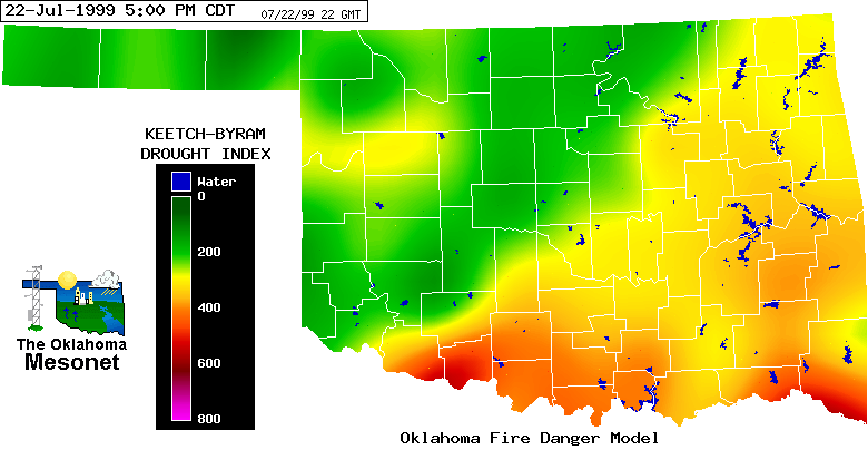
Earlier this week, the Ticker touched on a significant four-day change
in Keetch-Byram Drought Index (KBDI) conditions. Today, we've included
two more maps, seven days apart (Jul 15 and 22), which show a dramatic
increase.
The KBDI implies the state of near-surface soil moisture. On the images,
hotter colors indicate higher KDBI values, which indicate more drying
of the topmost layers of soil. The moisture content of these layers
can have a significant impact on wildfire intensity
From the evening of July 15th:
From the evening of July 22nd:
The Oklahoma Fire Danger Model:
http://agweather.mesonet.org/fire/data.html
July 23 in Mesonet History
| Record | Value | Station | Year |
|---|---|---|---|
| Maximum Temperature | 109°F | CHER | 2001 |
| Minimum Temperature | 54°F | ELRE | 2019 |
| Maximum Rainfall | 4.28 inches | TAHL | 2013 |
Mesonet records begin in 1994.
Search by Date
If you're a bit off, don't worry, because just like horseshoes, “almost” counts on the Ticker website!