Ticker for May 27, 1999
MESONET TICKER ... MESONET TICKER ... MESONET TICKER ... MESONET TICKER ...
May 27, 1999       May 27, 1999       May 27, 1999       May 27, 1999


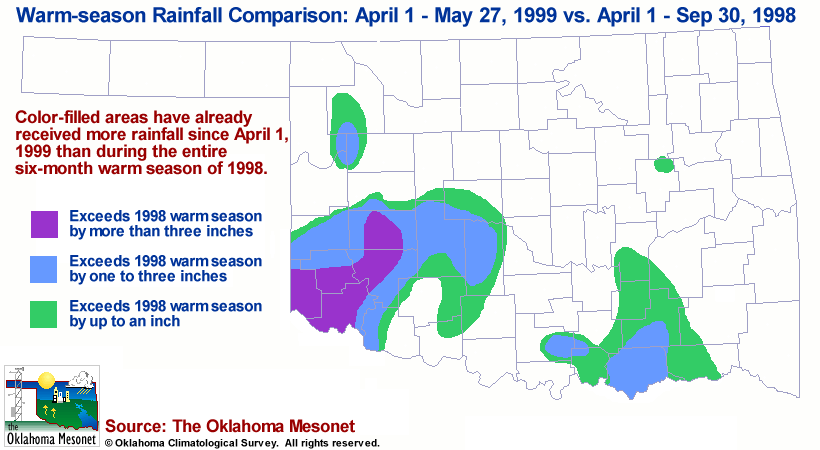
Once Again, What a Difference a Year Makes

As of 1:00 p.m. today, about one-quarter of the state has already
exceeded its six-month warm-season rainfall from 1998 in the first
eight weeks of the 1999 season.  The following graphic details the
contrast:


More Rainfall Drenches Southwestern Oklahoma

A slow-moving upper system has been responsible for heavy rains in
southwestern Oklahoma over the last few days, and today is no exception.

As of 2:00 p.m., six Mesonet stations had received more than an inch of
rainfall since midnight:

(Eight different Mesonet rainfall maps are updated every 15 minutes on
the Mesonet Subscriber's Data Page: http://www.mesonet.org/ )

Mangum       2.77"
Hobart       2.28"
Retrop       2.26"
Hollis       1.66"
Altus        1.07"
Erick        1.06"
Bessie       0.91"
Weatherford  0.74"
Butler       0.72"
Tipton       0.62"
Cheyenne     0.59"

No strong winds were observed by the Mesonet today.
May 27 in Mesonet History
| Record | Value | Station | Year |
|---|---|---|---|
| Maximum Temperature | 108°F | ALTU | 2011 |
| Minimum Temperature | 39°F | KENT | 2009 |
| Maximum Rainfall | 4.32″ | HOBA | 1999 |
Mesonet records begin in 1994.
Search by Date
If you're a bit off, don't worry, because just like horseshoes, “almost” counts on the Ticker website!