Ticker for May 26, 1999
MESONET TICKER ... MESONET TICKER ... MESONET TICKER ... MESONET TICKER ...
May 26, 1999       May 26, 1999       May 26, 1999       May 26, 1999


Severe Weather Recap
Severe storms with very large hail clipped the southwestern corner of
the state last night.  Eastern Oklahoma also received some significant
rainfall during the afternoon and evening hours.  Here's a brief
summary of pertinent Mesonet information, followed by a very
interesting event from the Texas panhandle.

Impressive wind gusts
Altus    55 mph    9:10 pm
Tipton   47 mph    8:40 pm
Tipton   45 mph    8:35 pm
Tipton   66 mph    8:30 pm
Tipton   63 mph    8:25 pm
Altus    56 mph    8:00 pm
Altus    58 mph    7:55 pm
Altus    59 mph    7:50 pm

Rainfall Totals
Tipton      1.64"
Altus       1.22"
Mangum      1.07"
Westville   0.93"
Grandfield  0.70"
Tahlequah   0.58"
Catoosa     0.31"
Erick       0.25"


Unusual Pattern on OK-FIRST Radar Scope

Today, the Ticker is taking a road trip of sorts.  Travelling the
region using the OK-FIRST NIDS radar viewer, we're going to look
at some of last night's storms in the Texas panhandle.  In particular,
two storms: one northwest and one just west of Amarillo.

What's unusual about these storms is that, despite just being a few
dozen miles apart, they appear to have "V-notches" in very different
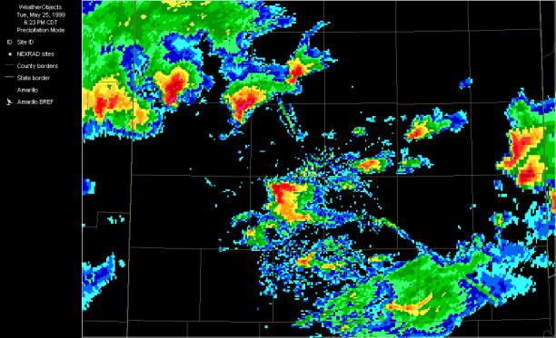
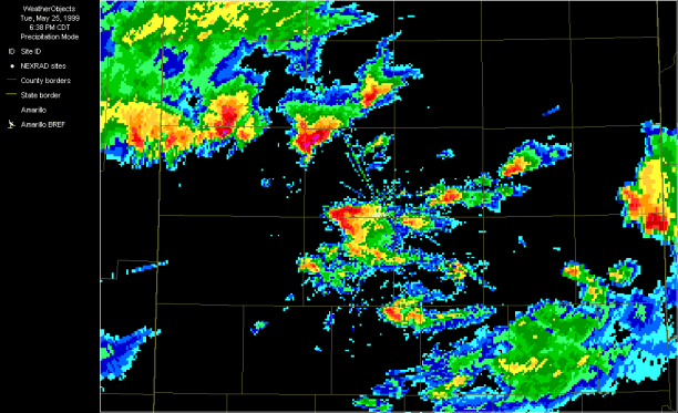
directions.  Take a look at five screen captures from the OK-FIRST
radar display.  The storm just west of center on the display seems
to show a v-notch which indicates westerly flow aloft, while the storm
to its north and west shows a more southerly signature.

6:23 pm
6:28 pm
6:33 pm
6:38 pm
6:43 pm

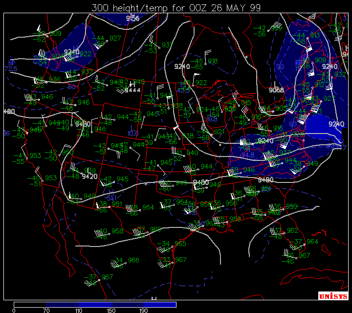
At first, it seems unlikely that winds aloft could be so diffluent to
support such a pattern.  However, a look at some upper air charts
from 0000 Z (about 30 minutes after these radar echoes) look like this
kind of diffluence might not be out of the question.

700 mb
500 mb
300 mb
200 mb

The missing observations over Amarillo at 300 mb and 200 mb might be
hiding the answers, especially at 300 mb.  At any measure, the
differences between the observations at OKC and Dodge City are
striking.

The author wishes he knew the answers, and maybe somebody in the Ticker
mailing list has a better angle on this.  But it's definitely something
interesting that popped up in the OK-FIRST data set.
May 26 in Mesonet History
| Record | Value | Station | Year |
|---|---|---|---|
| Maximum Temperature | 101°F | HOOK | 2006 |
| Minimum Temperature | 37°F | KENT | 2011 |
| Maximum Rainfall | 5.26″ | HINT | 2000 |
Mesonet records begin in 1994.
Search by Date
If you're a bit off, don't worry, because just like horseshoes, “almost” counts on the Ticker website!