MESONET TICKER ... MESONET TICKER ... MESONET TICKER ... MESONET TICKER ...
December 30, 2019 December 30, 2019 December 30, 2019 December 30, 2019
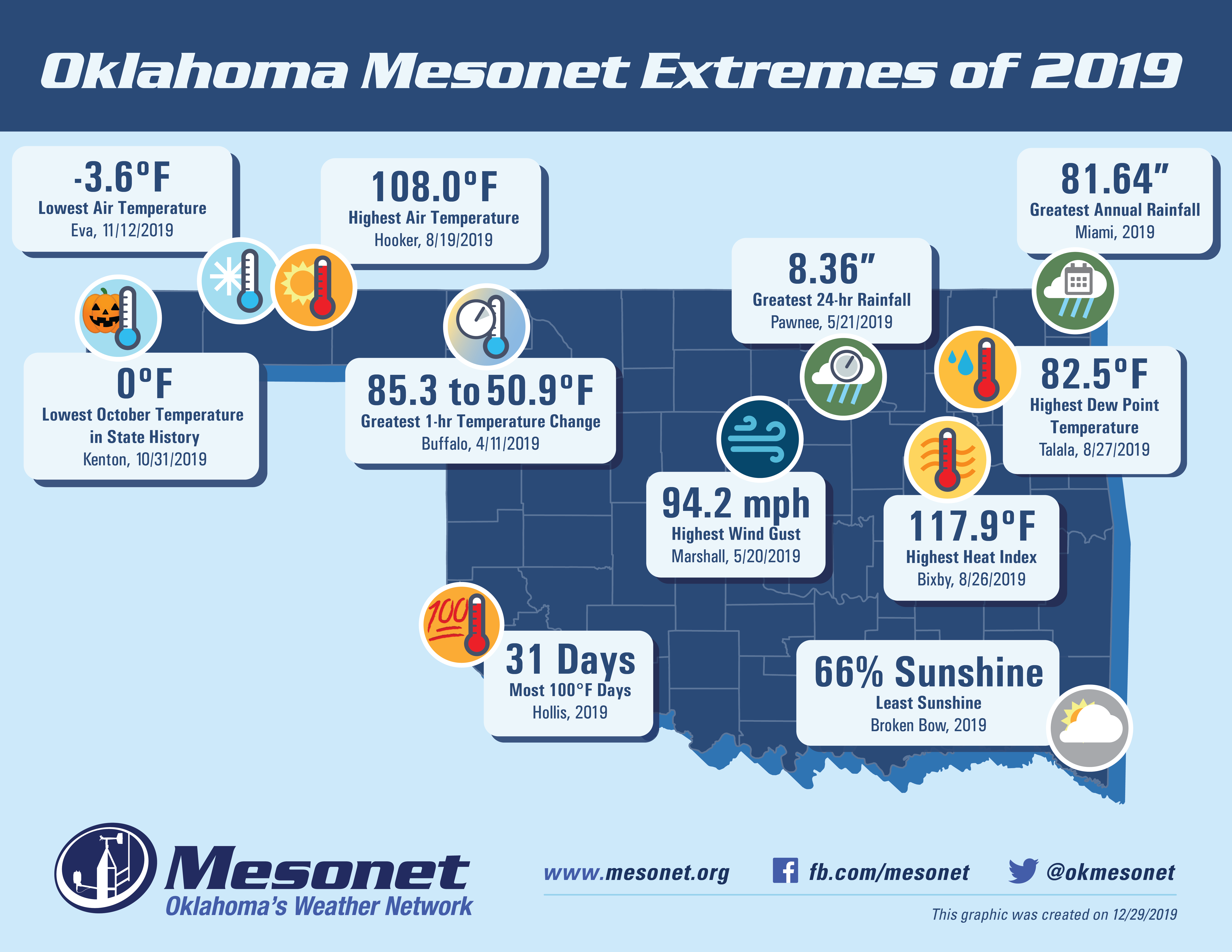
Extremely 2019
http://ticker.mesonet.org/archive/20191230/2019-extremes_final.png
It seems like it was just a year ago that we were posting this Mesonet extremes
figure. Oh wait, it was. As we sit bleary-eyed wondering how another year could
have passed so quickly, the true wonder remains exactly how Oklahoma continues
to produce such exhilarating environmental extremes. And remember, those are
just the parameters that we measure with the instruments of the Oklahoma Mesonet
(or calculate from those measurements). That says nothing that even in 2019's
last week, we increased our annual record tornado total from 146 to however many
tornadoes struck eastern Oklahoma on Dec. 28. At least one has been confirmed by
the Tulsa NWS office, so we'll put that record at 147 for now.
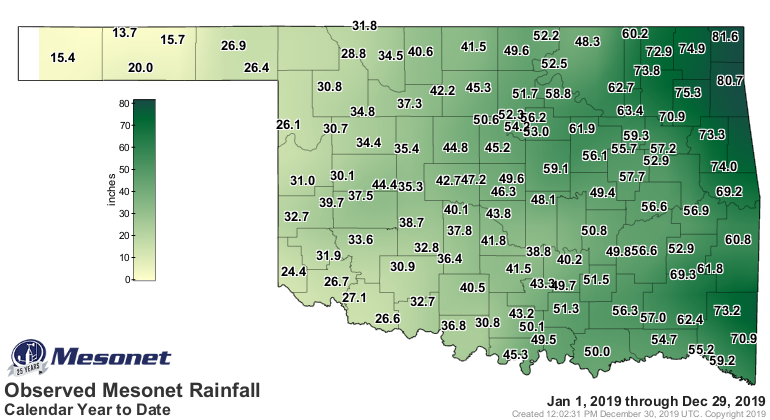
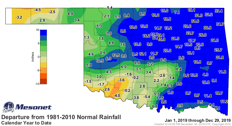
There were some equally momentous amounts from the Mesonet. Take the 81.64" of
rainfall at Miami. No, please. Hey, I ain't no Henny Youngman...these are the
jokes you get, folks! That rainfall total is 37.4" above normal. Let me repeat.
Okay, I won't. But that's an incredible amount of rainfall to hit the state of
Oklahoma. That's 2015 Godzilla El Nino territory right there, WITHOUT the aid
of the Godzilla El Nino. That's the highest of any official reporting station
in Oklahoma. There was a CoCoRaHS site at Jay that recorded 82.79", so obviously
the totals in far northeast Oklahoma shattered the previous annual records for
those locations.
Still far behind the current state record holder, the COOP site at Daisy with
89.69", but very impressive nonetheless. Simply put, one of the highest annual
rainfall totals ever recorded in the state of Oklahoma.
http://ticker.mesonet.org/archive/20191230/year.meso.png
http://ticker.mesonet.org/archive/20191230/year.norm_dep.png
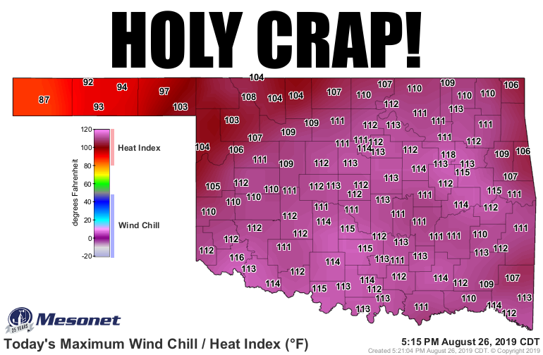
Then there's the not-so-fun stuff, like the heat index at Bixby on August 26 of
118 degrees. And the 108 degrees at Hooker on August 19 for the highest actual
air temperature recorded during the year. Both somewhat tame by Oklahoma
standards, but if you're at those locations experiencing those extremes, you
aren't having a fun day.
http://ticker.mesonet.org/archive/20191230/aug26-heat.index.png
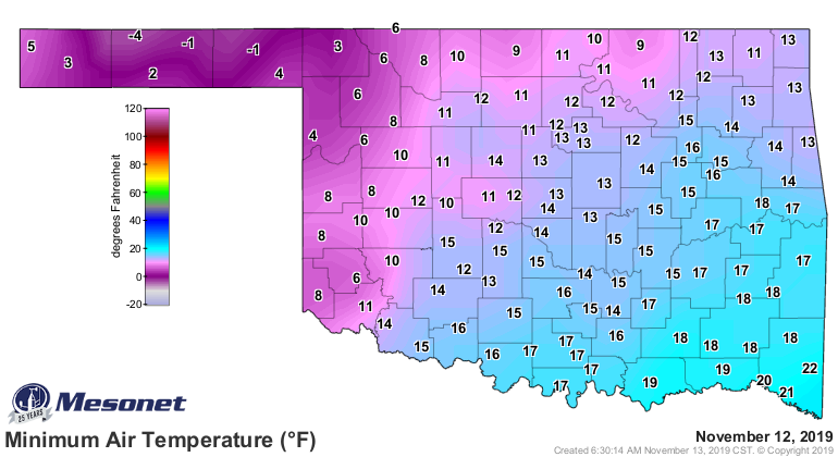
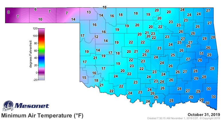
But that's a might sight better than the -4 degrees at Eva on November 12, or
trick-or-treating in sub-freezing weather like out at Kenton on Halloween this
year. The reading of zero degrees is the lowest temperature ever recorded in
Oklahoma in October, or that early in the cool season. Rather momentous.
http://ticker.mesonet.org/archive/20191230/nov12-lows.png
http://ticker.mesonet.org/archive/20191230/halloween-low-temps.png
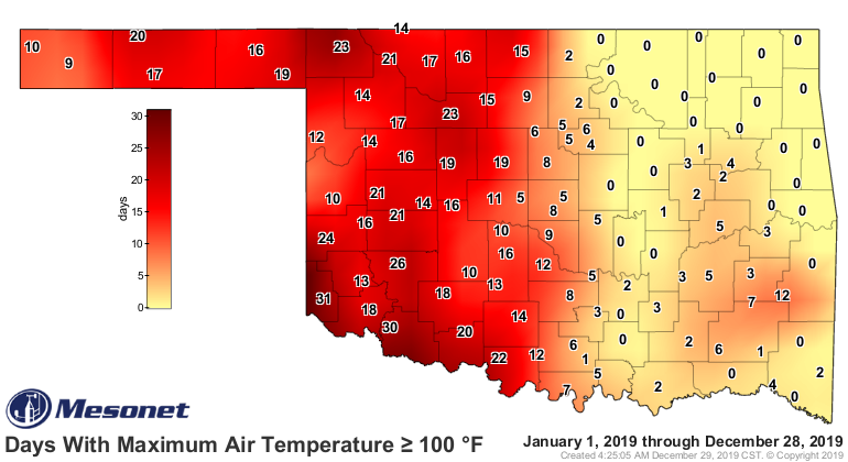
The 31 days at or above 100 degrees for Hollis again seems almost tame by our
standards, but the 94.2 mph wind gust at Marshall on May 20 (a date with worse
connotations) would blow your eyeballs out regardless of the location.
http://ticker.mesonet.org/archive/20191230/tmax.ge100.png
So we're extremely happy to be able to present the Mesonet extremes graphic for
yet another year. And we anxiously await the amazing meteorological wonders our
120 lonely sentinels -- the Oklahoma Mesonet sites -- will observe during 2020.
Some with trepidation, some with bated breath, always with anticipation, but
also with an understanding that this is the weather we are accustomed to in
Oklahoma...a land of weather extremes.
Gary McManus
State Climatologist
Oklahoma Mesonet
Oklahoma Climatological Survey
(405) 325-2253
gmcmanus@mesonet.org
==================================================
The OCS/Mesonet Ticker
https://ticker.mesonet.org/
To subscribe or unsubscribe from the Ticker
or for questions about the Ticker or its content
Phone or Email the Ticker Manager at OCS
Phone: 405-325-2253 Email: ticker@mesonet.org
---------------------------------------------------
-C- Copyright 2024 Oklahoma Climatological Survey
===================================================
|


 Tweet
Tweet