MESONET TICKER ... MESONET TICKER ... MESONET TICKER ... MESONET TICKER ...
December 14, 2015 December 14, 2015 December 14, 2015 December 14, 2015
Well that was interesting
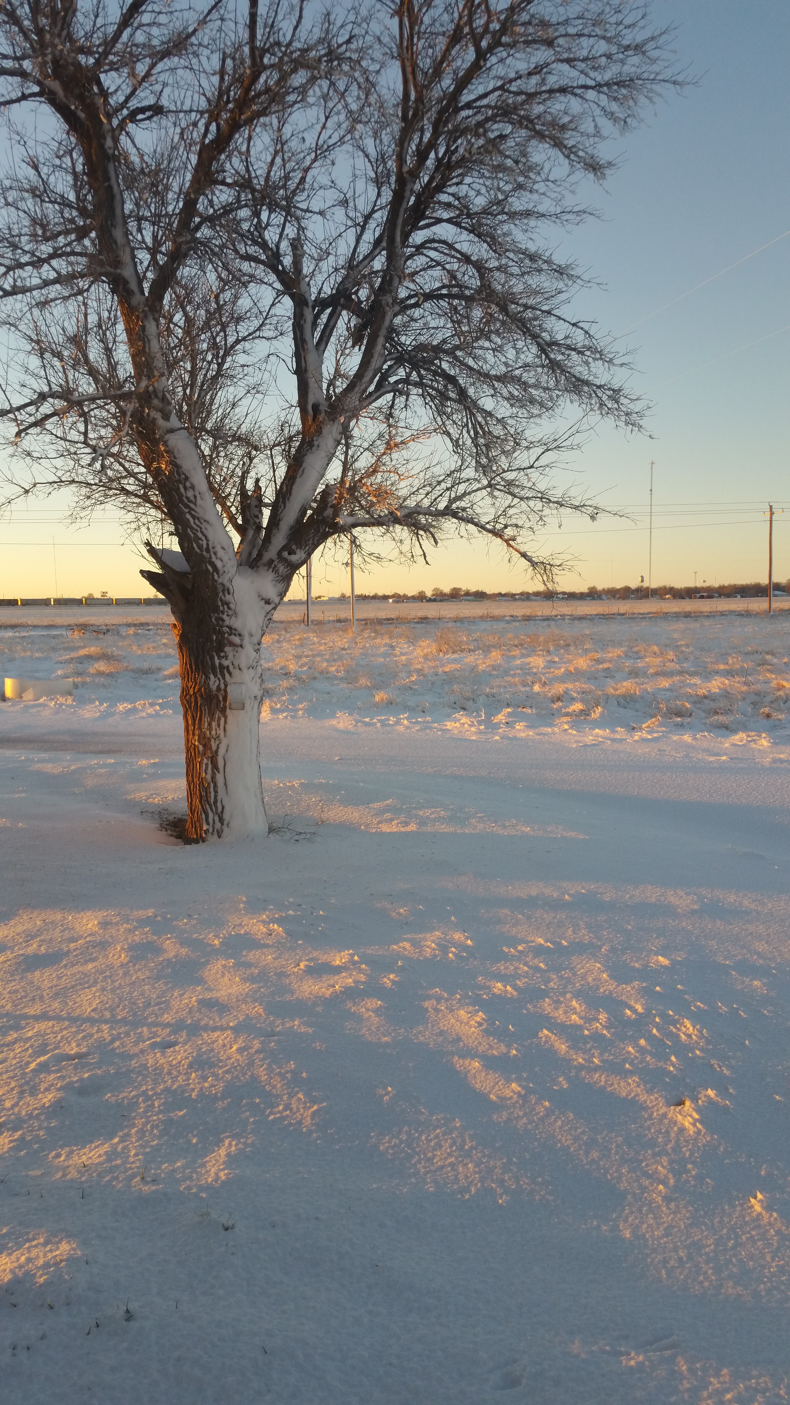
http://ticker.mesonet.org/archive/20151214/panhandle-snow.jpg
That snow-blasted tree sent in by a Ticker reader from the Texhoma area in
southern Texas County gives probably gives quite a few of the down-state folks
"snow envy." Not me, of course. I'm rather enjoying the recent spat of 60s and
70s. Or at least I was, until...
Another weekend, another storm system, another blizzard in the Panhandle, another
chance for me to use a sentence with a lot of anothers in it. And that's not even
a word! But we did see another bout of a spring/fall/winter system complete with
tornadoes (none in OK that I know of, but across the border in the Texas Panhandle
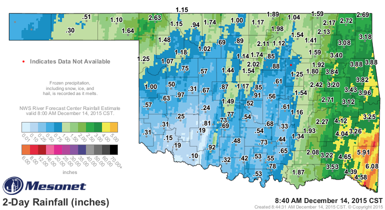
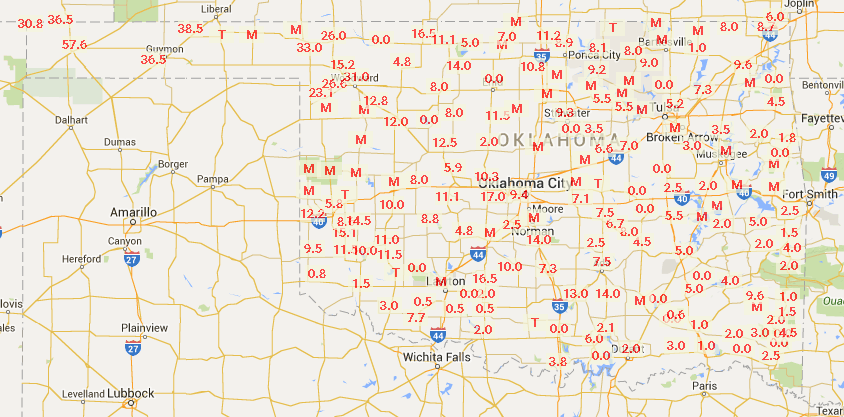
and also NE Texas), heavy rain, and snow. The rainfall totals look to be the
greatest in the NW, NC and then the eastern third of the state. Extremely heavy
rains across SE OK led to flooding.
http://ticker.mesonet.org/archive/20151214/rainrfc.48hr.png
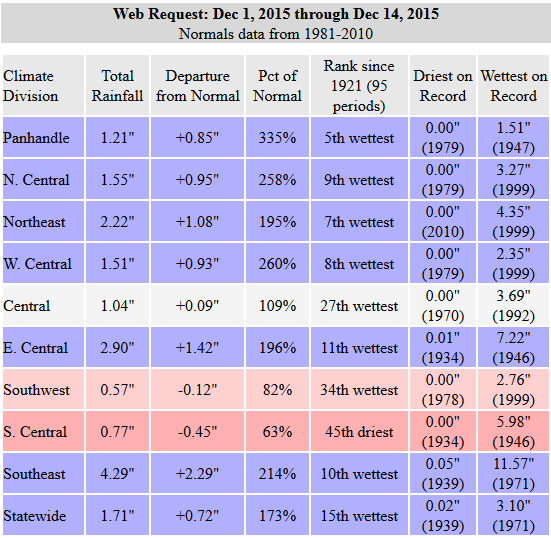
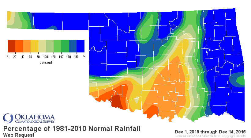
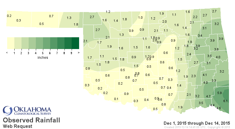
And in case we were still worried about that new annual statewide average
rainfall record verifying, we're now up to almost 2 inches for the month of
December, so adding that onto the January-November total of 48 inches should
belay any of those fears.
http://ticker.mesonet.org/archive/20151214/dec1-14-stats.png
http://ticker.mesonet.org/archive/20151214/dec1-14-pct-normal.png
http://ticker.mesonet.org/archive/20151214/dec1-14-totals.png
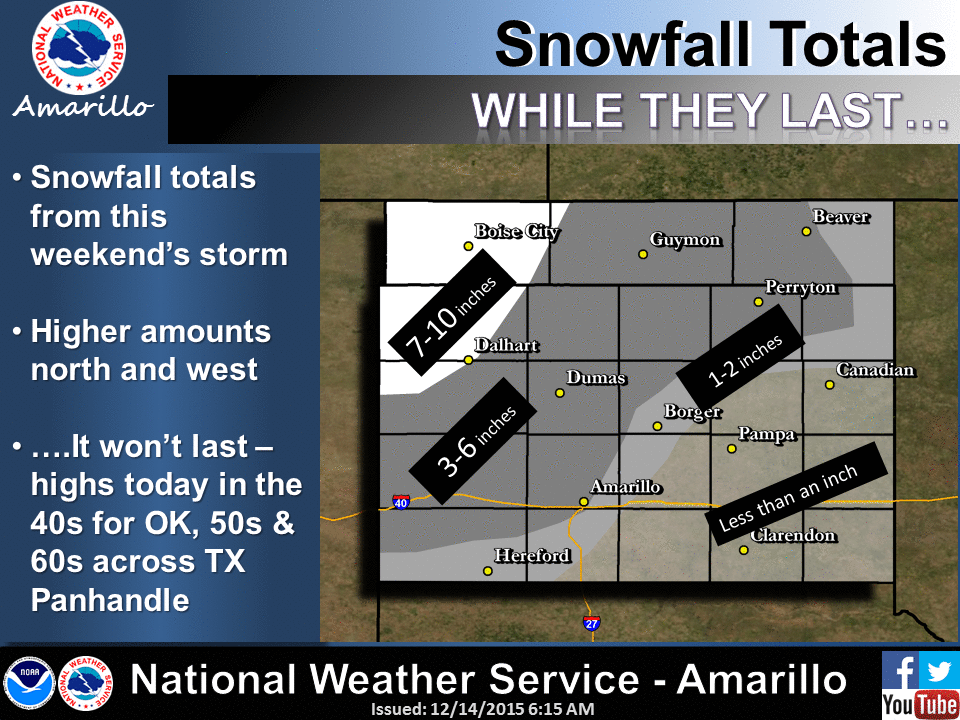
The snow totals I've seen from out across the western Panhandle range from
about a foot in the NE wart of Cimarron County to about 3 inches in Beaver in
the eastern Panhandle. Combine that with winds gusting to near 50 mph in some
cases and you're living in a winter non-wonderland (hence the snow-blasted tree
above).
http://ticker.mesonet.org/archive/20151214/nws-amarillo-snow.totals.gif
Nothing unexpected here during this super-strong El Nino year. We looked
at the snowfall from the last two similarly strong El Ninos (1982-83 and 1997-98)
and sure enough, the far NW and Panhandle tended to get pounded whilst the
results for the rest of the state were a bit more mixed.
http://ticker.mesonet.org/archive/20150814/1982-83-snow.totals.png
http://ticker.mesonet.org/archive/20150814/1997-98-snow.totals.png
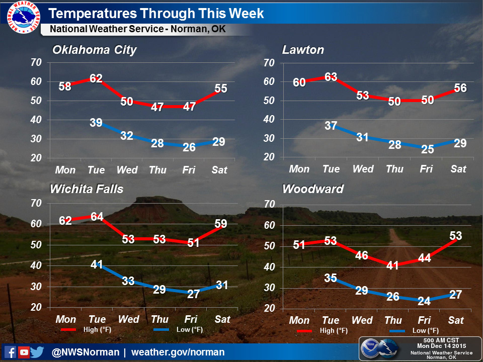
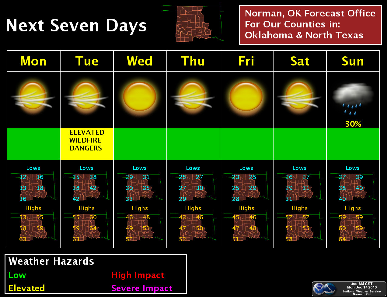
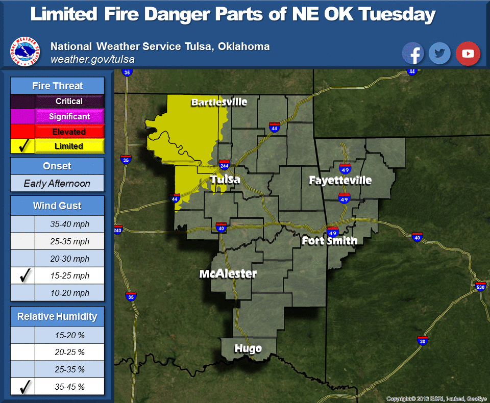
Okay, enough of that! Let's get to the really exciting weather! Did I say
exciting? I meant "really boring." Other than a dry cold front or two, the rest
of the week looks rather blah with high temps fluctuating from the 40s to 60s
back to the 40/50s. And no moisture. Maybe at the end of next weekend? Other
than that, the only thing that is interesting in the least is a bit of fire
danger tomorrow (greater out west).
http://ticker.mesonet.org/archive/20151214/nws-norman-temps.jpg
http://ticker.mesonet.org/archive/20151214/nws-norman-7day-planner.jpg
http://ticker.mesonet.org/archive/20151214/nws-tulsa.png
If you're looking for a white Christmas, I'm still seeing warmer than normal
weather. And that's not just for Oklahoma but much of the country. Never fear,
it could still change. I hope not. I wrote Santa and asked for 70s on Christmas
Day!
Bah humbug yourself!
Gary McManus
State Climatologist
Oklahoma Mesonet
Oklahoma Climatological Survey
(405) 325-2253
gmcmanus@mesonet.org
==================================================
The OCS/Mesonet Ticker
https://ticker.mesonet.org/
To subscribe or unsubscribe from the Ticker
or for questions about the Ticker or its content
Phone or Email the Ticker Manager at OCS
Phone: 405-325-2253 Email: ticker@mesonet.org
---------------------------------------------------
-C- Copyright 2024 Oklahoma Climatological Survey
===================================================
|


 Tweet
Tweet