MESONET TICKER ... MESONET TICKER ... MESONET TICKER ... MESONET TICKER ...
December 1, 2013 December 1, 2013 December 1, 2013 December 1, 2013
November Brings Early Taste of Winter
A special Sunday Ticker, because you demanded it (and because I'm going to be
traveling tomorrow, today we bring you a summary of November's weather. Enjoy,
because it looks like we're going to see more of the same later this week.
----------------------------------------------------------------------------------
November is considered a fall month climatologically, but it certainly did its
best to look like a winter month during 2013. Emphatically cooler than normal,
thanks mostly to a frigid outburst by Mother Nature during its final 10 days,
November was punctuated by an early cool-season snowstorm that dumped more than a
foot of snow across southwestern Oklahoma. According to data from the Oklahoma
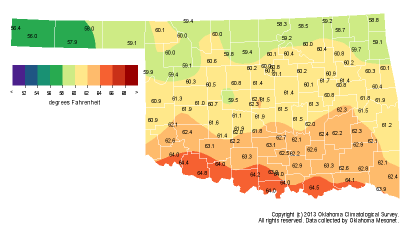
Mesonet, the statewide average temperature for the month ended 1.8 degrees below
normal at 46.5 degrees, the 33rd coolest November since records began in 1895.
http://ticker.mesonet.org/archive/20131201/avgtavg.png
http://ticker.mesonet.org/archive/20131201/deltavg.png
November was the eighth month during 2013 to finish with below normal
temperatures. Prior to that, 28 out of the 34 months between April 2010 and
January 2013 had been warmer than normal. The January-November statewide
average of 61.1 degrees is the 40th coolest such period on record at half of a
degree below normal, standing in stark contrast to last year's mark of 65
degrees over the same period. The fall season itself, however, was actually 0.2
degrees above normal and ranked as the 59th warmest on record.
Fall Temperature Maps
http://ticker.mesonet.org/archive/20131201/fall-avgtavg.png
http://ticker.mesonet.org/archive/20131201/fall-deltavg.png
January-November Temperature Maps
http://ticker.mesonet.org/archive/20131201/jan-nov-avgtavg.png
http://ticker.mesonet.org/archive/20131201/jan-nov-deltavg.png
The lowest temperature recorded by the Mesonet was 9 degrees from Alva on the
ninth, and the highest temperature of 85 degrees occurred at Altus on the 16th.
Moisture was plentiful in a few select areas, but scarce for most. The
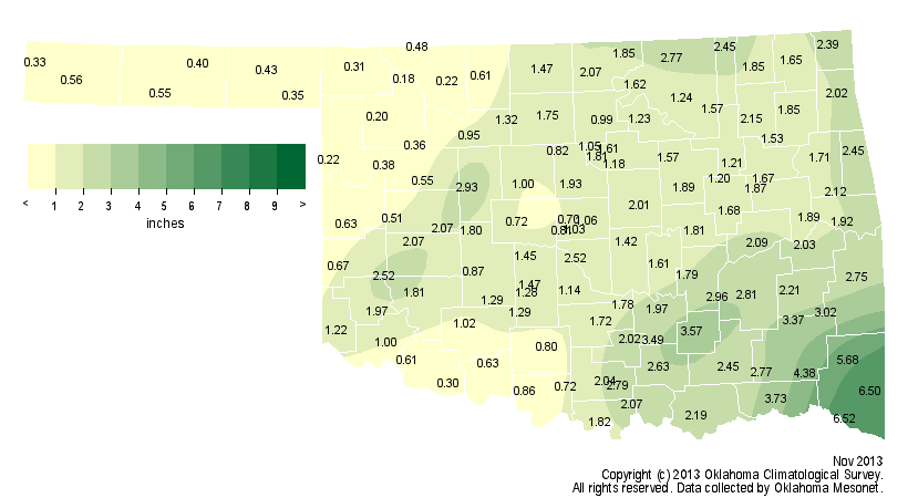
statewide average precipitation total as measured by the Mesonet came in at
1.64 inches, more than an inch below normal, to rank as the 47th driest
November on record. The most notable exception was drought-parched southwestern
Oklahoma, a result of their late-month wintry blast, although far southeastern
Oklahoma saw some hefty precipitation totals as well. Other than those lucky
few, the rest of the state saw deficits of 1-3 inches. Far northwestern
Oklahoma was particularly dry with less than 20 percent of normal November
rainfall.
November Rainfall Maps
http://ticker.mesonet.org/archive/20131201/totrain.png
http://ticker.mesonet.org/archive/20131201/pctrain.png
http://ticker.mesonet.org/archive/20131201/delrain.png
Fall was also dry with a statewide average of 7.22 inches, 2.8 inches below
normal, to rank as the 45th driest on record.
Fall Rainfall Maps
http://ticker.mesonet.org/archive/20131201/fall-totrain.png
http://ticker.mesonet.org/archive/20131201/fall-delrain.png
The Mesonet station at Idabel led the state during November with 6.52 inches
while Freedom recorded a meager 0.18 inches.
The wintry precipitation actually came in two successive waves. The first
storm brought a light glaze of ice to the state on the 22nd and 23rd and wind
chills down into the single digits. The more powerful storm struck on the 24th
and 25th with snow, sleet and freezing rain falling over a large area, creating
widespread traffic problems and scattered power outages. National Weather
Service (NWS) cooperative observers at Altus, Hobart and Vinson all recorded
13 inches of snow during the storm on November 24 and 25, and the Mangum
observer was close behind with 11 inches. Widespread totals of 4-6 inches were
reported across other parts of southwestern Oklahoma.
http://ticker.mesonet.org/archive/20131201/nws-norman-snowtotals.jpg
Some snow spread to the north and east from the storm, but the rest of the
state saw precipitation mainly in the form of rain, sleet and freezing rain.
Oklahoma City saw less than an inch of snow during the storm and Tulsa recorded
a trace.
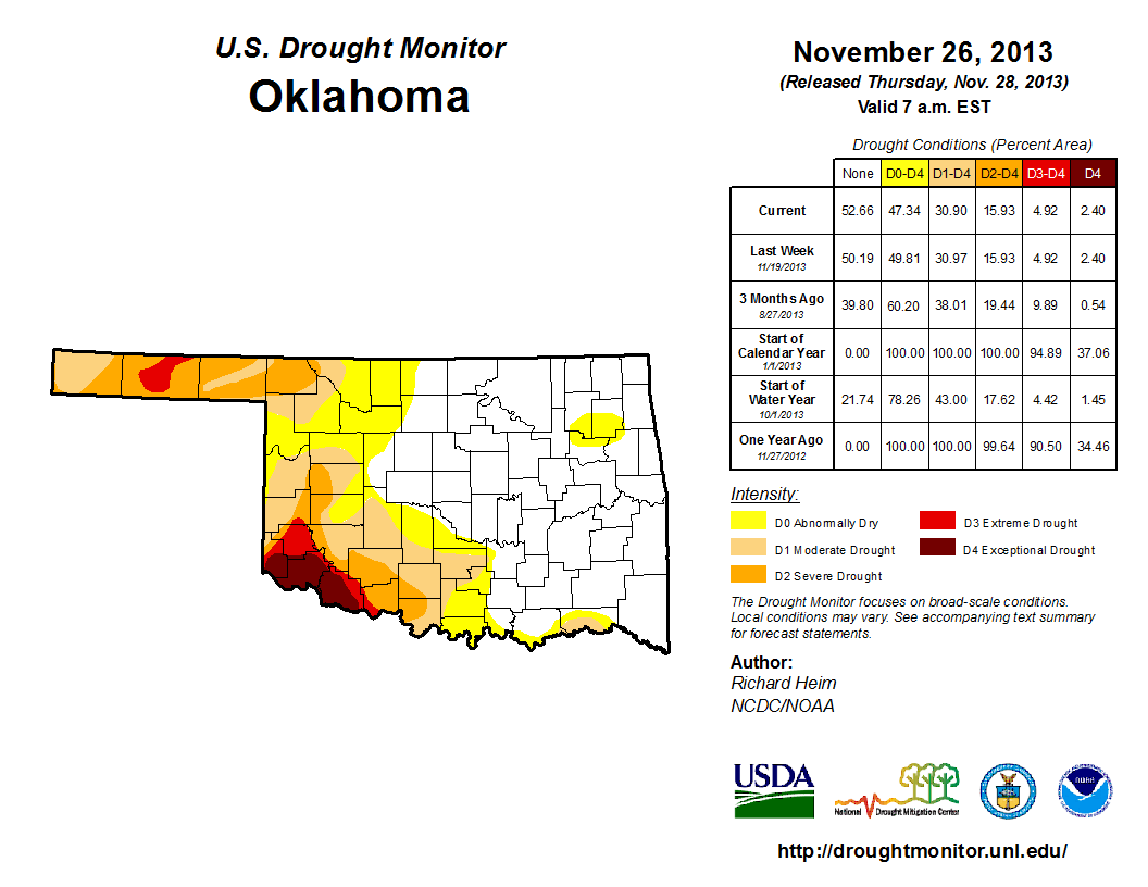
Very little change occurred in drought conditions during November according to
the U.S. Drought Monitor. There was an increase in drought intensity across far
southwestern and west central Oklahoma, but a bit of a decrease across south
central Oklahoma. At month's end, 31 percent of Oklahoma remained in some
intensify of drought on the Drought Monitor, almost entirely within the western
one-third of the state.
http://ticker.mesonet.org/archive/20131201/oct29-DM.png
http://ticker.mesonet.org/archive/20131201/nov26-DM.png
The December precipitation outlook from the NWS' Climate Prediction Center
(CPC) indicates increased odds of below normal moisture for Oklahoma. The
outlook for temperature is much less certain with equal chances of below-,
above- and near-normal temperatures during December.
http://ticker.mesonet.org/archive/20131201/dec-precip-outlook.gif
http://ticker.mesonet.org/archive/20131201/dec-temp-outlook.gif
An extended visit by an arctic air mass does look likely for late in the first
week and into the second week of the month, so that might be enough to tip the
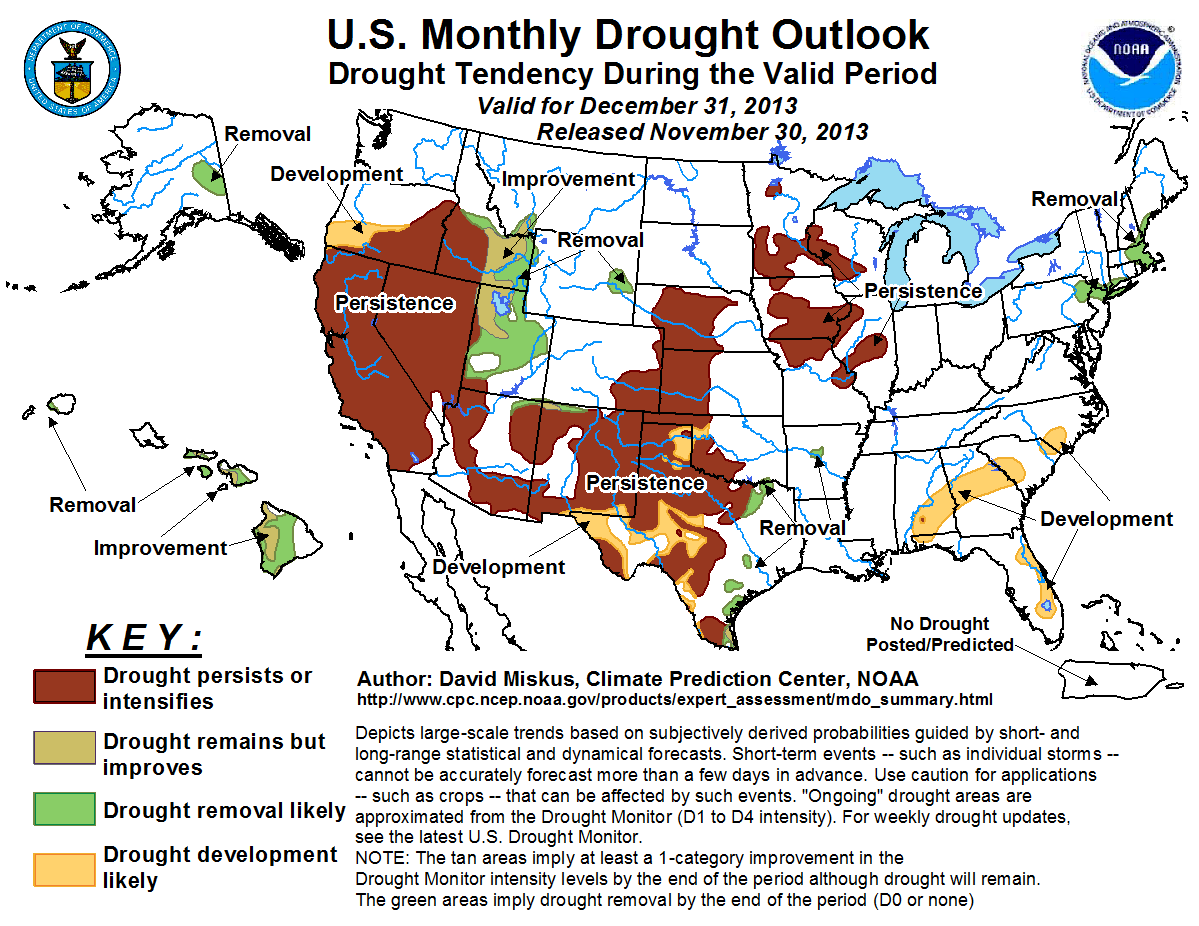
odds to the cool side. CPC's Monthly Drought Outlook for December calls for
drought to persist across those areas of Oklahoma where it is already in place,
but also for more development across far western Oklahoma.
http://ticker.mesonet.org/archive/20131201/dec-drought-outlook.png
CPC's winter outlook for the December-February period sees increased odds of
above normal temperatures, but no definitive outlook for precipitation.
http://ticker.mesonet.org/archive/20131201/dec-feb-precip-outlook.gif
http://ticker.mesonet.org/archive/20131201/dec-feb-temp-outlook.gif
Gary McManus
Associate State Climatologist
Oklahoma Climatological Survey
(405) 325-2253
gmcmanus@mesonet.org
==================================================
The OCS/Mesonet Ticker
https://ticker.mesonet.org/
To subscribe or unsubscribe from the Ticker
or for questions about the Ticker or its content
Phone or Email the Ticker Manager at OCS
Phone: 405-325-2253 Email: ticker@mesonet.org
---------------------------------------------------
-C- Copyright 2024 Oklahoma Climatological Survey
===================================================
|


 Tweet
Tweet