MESONET TICKER ... MESONET TICKER ... MESONET TICKER ... MESONET TICKER ...
November 19, 2015 November 19, 2015 November 19, 2015 November 19, 2015
One wet winter, coming up!
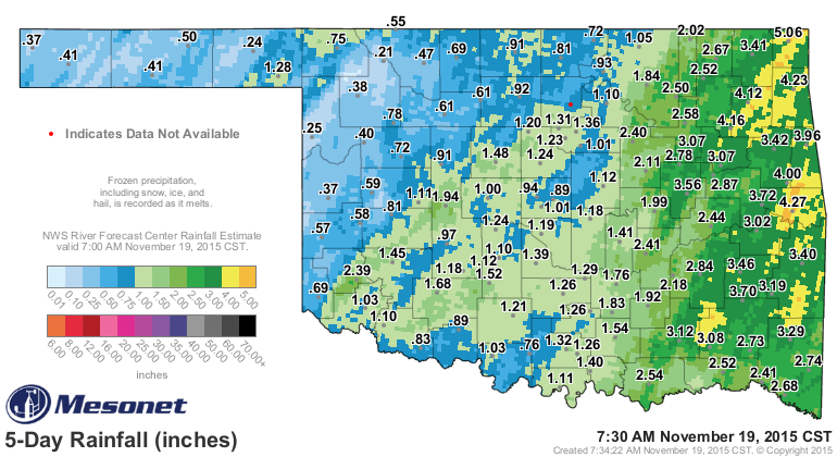
Before we get to that winter outlook, let's take a look at how the recent rains
impacted this week's drought monitor. First, as expected, the rain was very
"convective" in nature across the western sections of the state (i.e., it rained
the most where the storms traveled through, and a degree lesser in between those
storms), and more widespread farther to the east where the front stalled out and
allowed for a longer, slower rainfall.
http://ticker.mesonet.org/archive/20151119/rainrfc.120hr.png
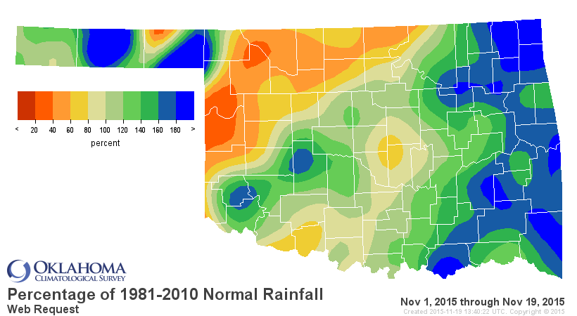
Those rains also bring up the November total (thus far) to the 22nd wettest
Nov. 1-19 since at least 1921 with a statewide average of 2.2", .52" above normal.
There are still parts of the state where the dry weather continues to dominate,
specifically from west central through north central Oklahoma.
http://ticker.mesonet.org/archive/20151119/nov1-19-pct-normal.png
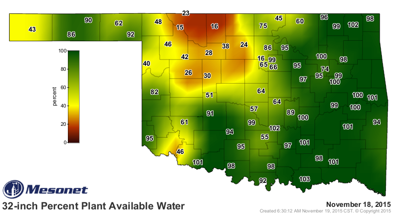
We can also see that dryness (and wetness in other places) in the soil moisture
maps. The 32-inch Percent Plant Available Water map is derived by dividing the
current daily 32-inch Plant Available Water value by the theoretical maximum
32-inch plant available water amount for each individual Mesonet site. The
percent reported is for the soil column from the soil surface down to the
32-inch depth.
http://ticker.mesonet.org/archive/20151119/32inch-pct-plant-water.png
The other soil moisture maps can be found here:
http://www.mesonet.org/index.php/weather/category/soil_moisture
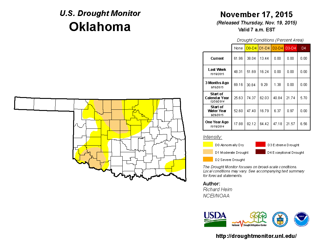
All that leads us to the latest U.S. Drought Monitor map.
http://ticker.mesonet.org/archive/20151119/20151117_OK_trd.png
Drought is now eradicated across the entire eastern half of the state, with
patches of "abnormally dry" left in the far SE and N OK. Remember, abnormally
dry conditions ARE NOT DROUGHT, SO DON'T LET ME CATCH YOU SAYING SO or, well,
nothing really, just don't! There is still a fair amount of moderate drought
from Woods-Alfalfa-Grant counties down to northern OK County. Also across far
SW OK. Hopefully we will see that drought eradicated because...
-------------------------------------------------------------------------------
CPC's U.S. Winter Outlook
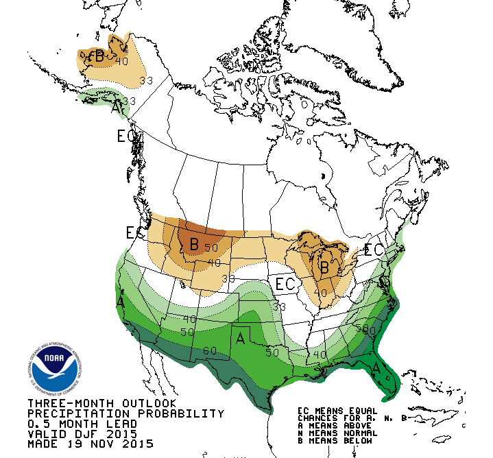
Thanks to a large helping of what is now being considered one of the strongest
El Nino's on record, the winter months across Oklahoma are seeing greatly
increased probabilities of above normal precipitation, especially across that
very region in western Oklahoma still seeing drought.
http://ticker.mesonet.org/archive/20151119/dec-feb-precip-outlook.gif
In fact, those odds across western Oklahoma are a fairly significant 50%, meaning
if you had a dollar to bet on what precip region you'd see, you'd go 50 cents
on above normal conditions, 33 cents on near-normal conditions, and only 17
cents on below normal precip. Not too shabby. And in the classic El Nino
impact pattern, the northern tier of the U.S. might expect drier than normal
weather.
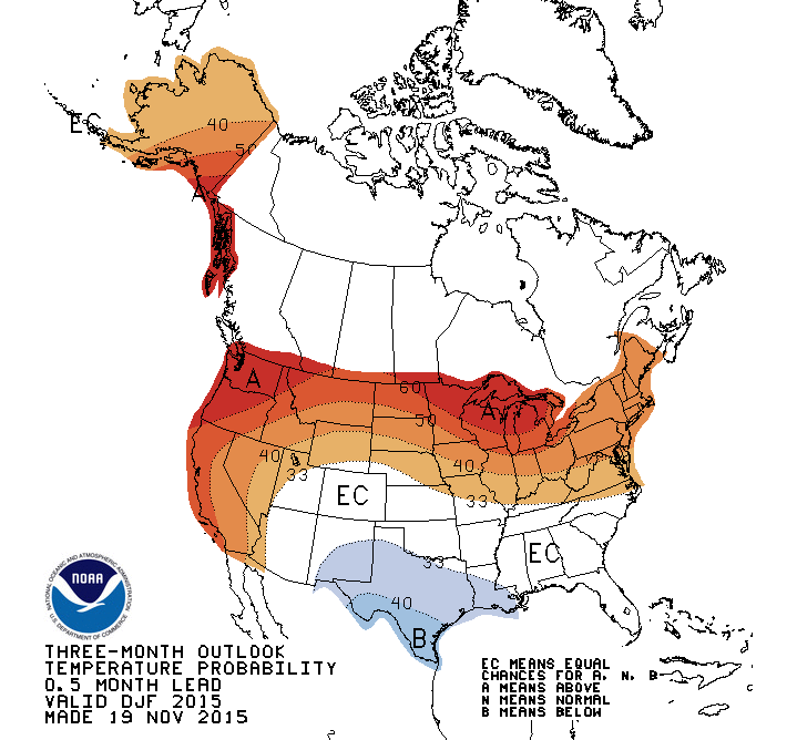
As for temperature, even though the CPC outlook calls for a classic El Nino
signature there as well (cooler than normal in the Southern Plains, warmer
than normal in the North), Oklahoma is stuck in the dreaded "Equal Chances (EC)"
zone.
http://ticker.mesonet.org/archive/20151119/dec-feb-temp-outlook.gif
Now once again, THIS DOESN'T MEAN NORMAL TEMPERATURES ARE FAVORED, SO
DON'T LET ME...well, never mind on that. Given the previous dollar example,
you'd bet 33 cents on below normal temps, 33 cents on near normal temps, and
33 cents on above normal temps. In other words, a punt! And the extra penny
can go to your friendly neighborhood state climatologist, in a fund to give
angry glares at people that call "abnormally dry" conditions drought.
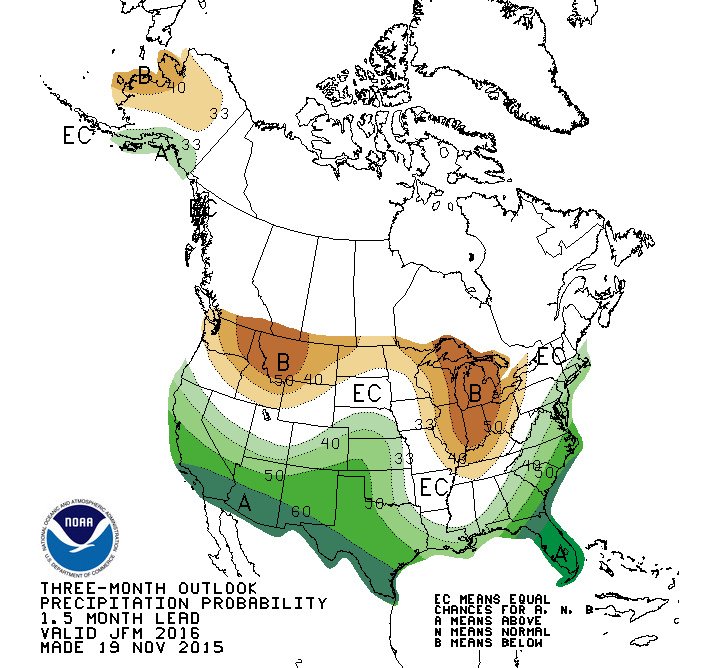
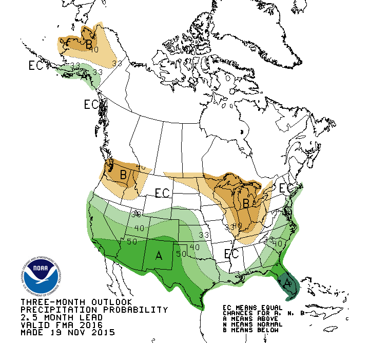
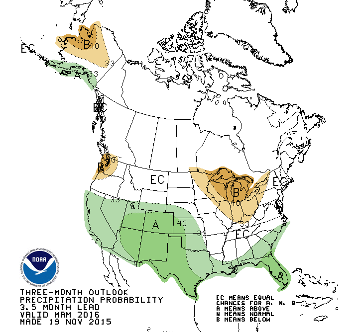
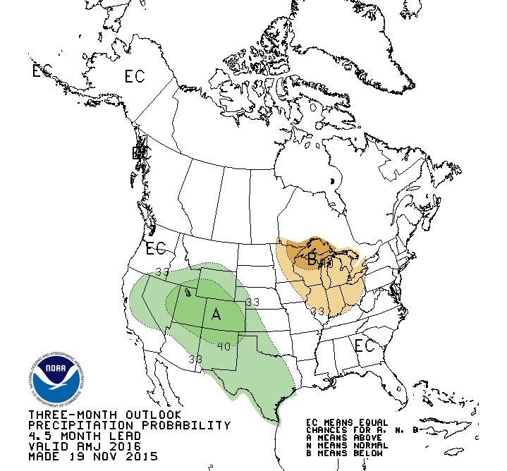
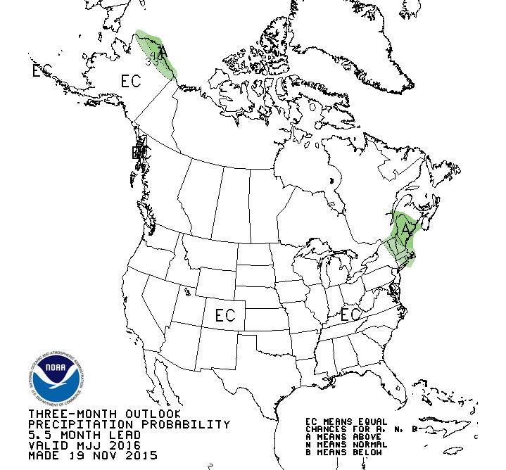
El Nino's wet teleconnection to the Southern Plains can bleed over from winter
into early spring. It's impacts are greatest from December-March, after all, so
the outlooks for the January-March through the April-June period all have
some type of tilted odds towards wetter than normal weather, especially across
western OK
http://ticker.mesonet.org/archive/20151119/JFM-precip-outlook.gif
http://ticker.mesonet.org/archive/20151119/FMA-precip-outlook.gif
http://ticker.mesonet.org/archive/20151119/MAM-precip-outlook.gif
http://ticker.mesonet.org/archive/20151119/AMJ-precip-outlook.gif
before finally fading away in the May-July period.
http://ticker.mesonet.org/archive/20151119/MJJ-precip-outlook.gif
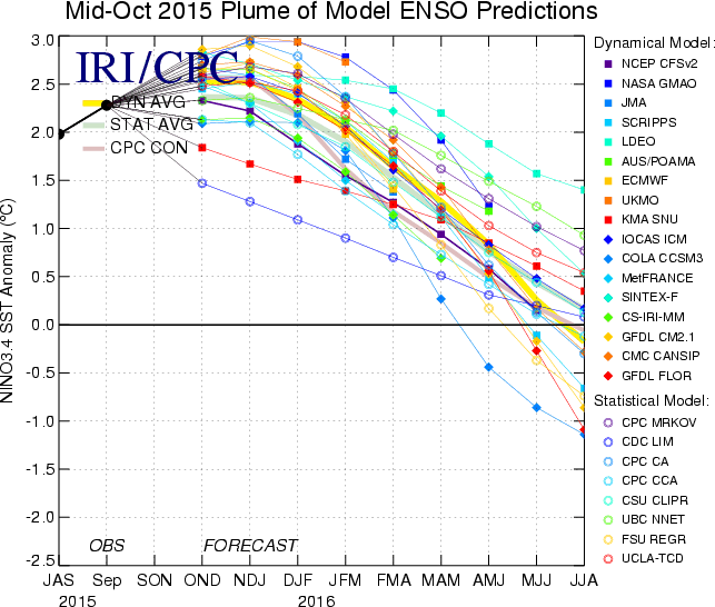
A bit of caution is still needed here. This El Nino is supposed to peak in about
the next month or so, becoming one of the strongest on record (at least since
1950).
http://ticker.mesonet.org/archive/20151119/enso-plume.gif
But it still has to behave as a strong El Nino should, which is not guaranteed.
Oklahoma is not typically as impacted as Texas is, but that's not to say we
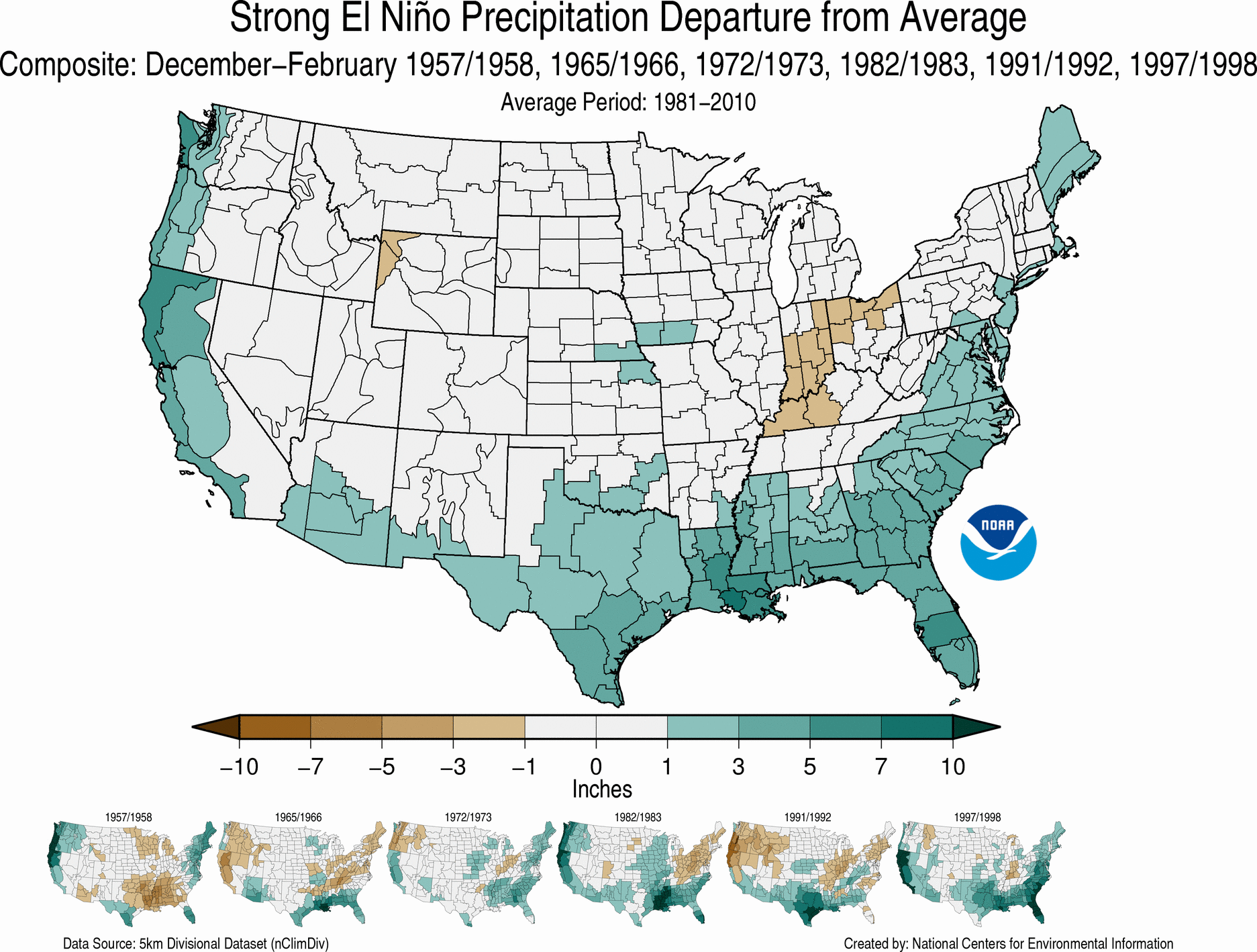
don't see the same types of impacts more often than not. If you look at the
precip anomalies for ALL the strong El Nino events since 1950 (1957-58, 1965-66,
1972-73, 1982-83, 1991-92, and 1997-98, you'll see (not surprisingly) that the
southern tier of Oklahoma feels the greatest impacts. But if you look at the
INDIVIDUAL anomalies below the composite, concentrate on the three to the right,
or those most recent ones (1982-83, 1991-92 and 1997-98). You can definitely
see much more of an impact across more of Oklahoma than in the former three.
That gives me hope we'll see conditions more like the latter three than the
former.
http://ticker.mesonet.org/archive/20151119/conus-prcp-diff-dec-feb.gif
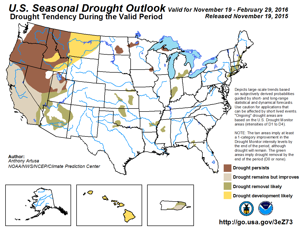
For drought, the news should be good (again, if it works the way we think
it should). The U.S. Seasonal Drought Outlook through February obviously has
no areas of drought development across OK, but drought eradication where it
currently exists.
http://ticker.mesonet.org/archive/20151119/season_drought.png
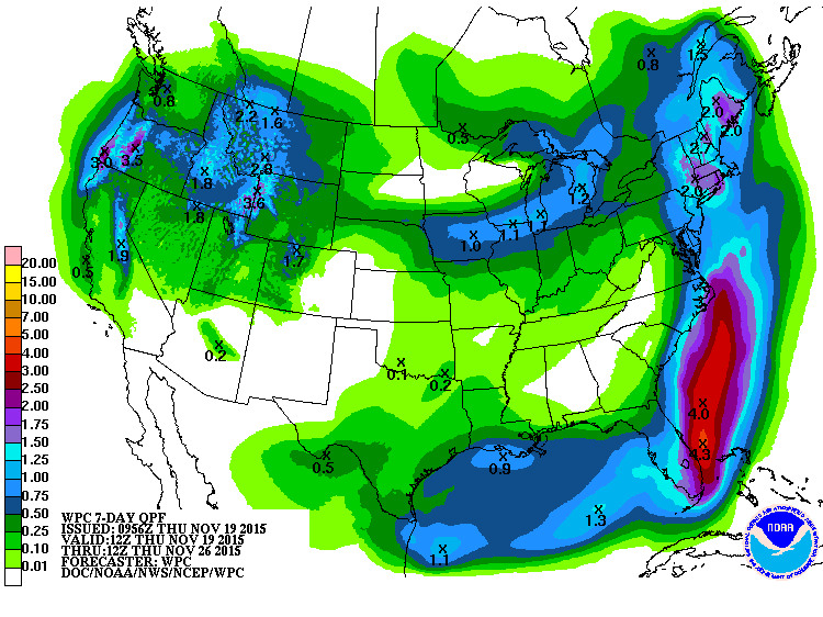
We don't see too much evidence of the wet stuff until we get closer to
Thanksgiving. Right now it looks to be a mild rain (if that at all, since it's
a week out), but it is starting to paint the moisture forecast green. Hopefully
that will get more green and blue as we go through the next week.
http://ticker.mesonet.org/archive/20151119/7day-rain-forecast.gif
So let's sit back and let it El Nino.
Goodbye.
Gary McManus
State Climatologist
Oklahoma Mesonet
Oklahoma Climatological Survey
(405) 325-2253
gmcmanus@mesonet.org
==================================================
The OCS/Mesonet Ticker
https://ticker.mesonet.org/
To subscribe or unsubscribe from the Ticker
or for questions about the Ticker or its content
Phone or Email the Ticker Manager at OCS
Phone: 405-325-2253 Email: ticker@mesonet.org
---------------------------------------------------
-C- Copyright 2024 Oklahoma Climatological Survey
===================================================
|


 Tweet
Tweet