Ticker for November 15, 2012
MESONET TICKER ... MESONET TICKER ... MESONET TICKER ... MESONET TICKER ...
November 15, 2012 November 15, 2012 November 15, 2012 November 15, 2012
Even Steven
We had drought advance in part of the state and retreat in others, but all in all,
pretty much the same numbers. Seinfeld called it "Even Steven." I like to say
that's just our naturally varying weather. Farmers call it something I probably
shouldn't say on here. This week's U.S. Drought Monitor map tells the story of
the changes in impacts following the rain over last weekend.
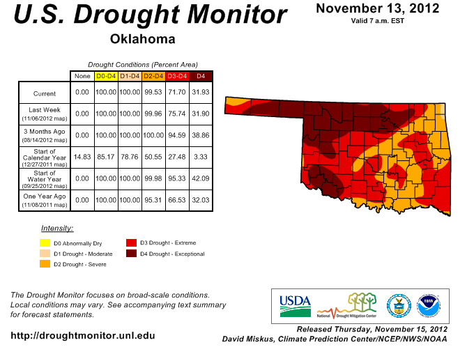
So if you will notice, we had severe (D2) drought extend farther to the southwest
into Grady County and also up through Tulsa County in the northeast. There is
still a very small area of moderate (D1) drought up in the far northeastern
corner of the state as well. We also saw that exceptional (D4) drought expand
in the Panhandle to cover all of Beaver County now. So the percentage of
remained virtually unchanged at 32%, while the D3 dropped by about 4%. The area
of the state covered by severe-exceptional (D2-D4) remained just a tad under
100%.
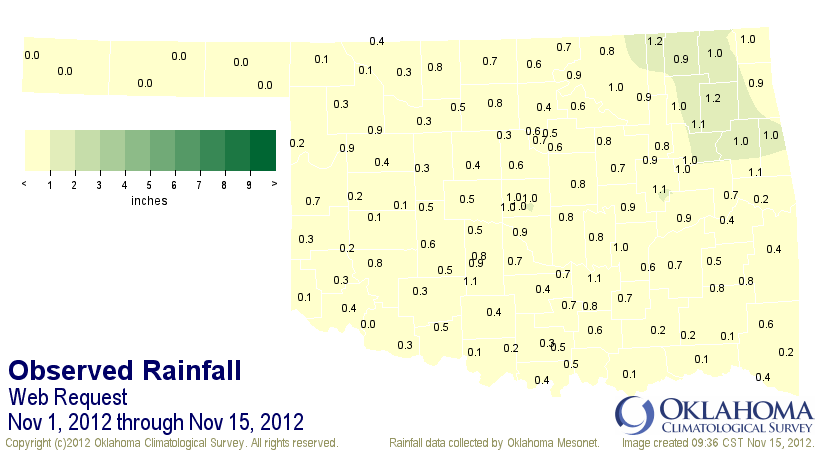
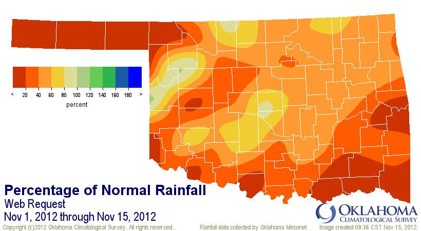
If things don't change in a hurry, November is on its way to a dismal finish.
Through the 15th, the state has had an average of 0.54 inches of rain, nearly an
inch below normal. It's normally one of our drier months anyway, regardless of
deficits.
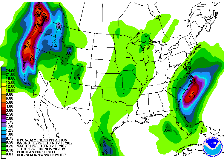
The next five days are mostly dry, although there is expected to be a little bit
of rain with a storm system early next week. The amounts at this time are
expected to be pretty light, however.
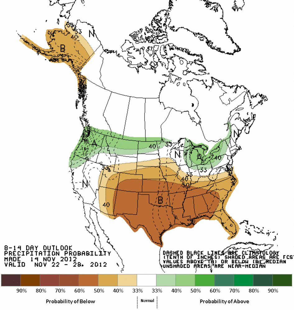
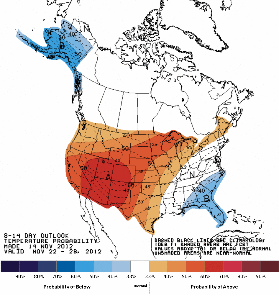
At this time, the remainder of November looks fairly warm and dry with
increased odds of warmer and drier than normal weather forecast by the
NWS' Climate Prediction Center (CPC). The worrisome part there is that drier
than normal this time of the year is REALLY dry.
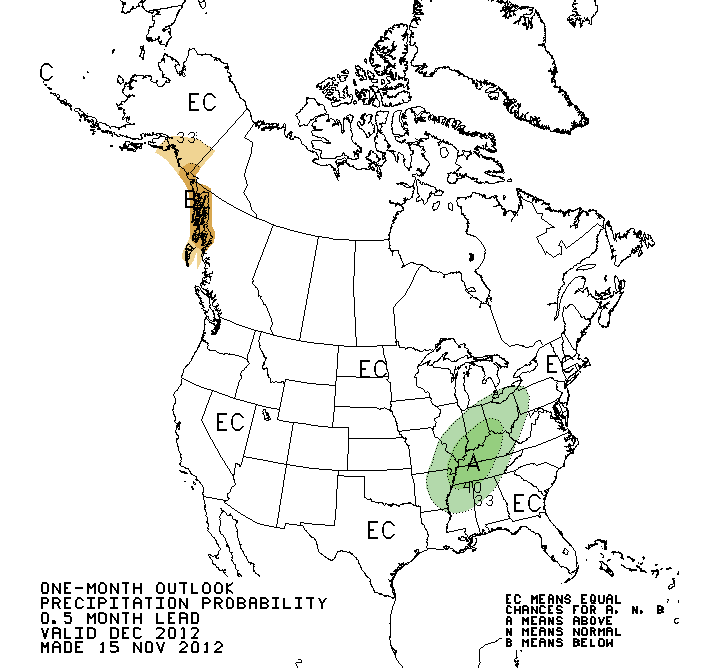
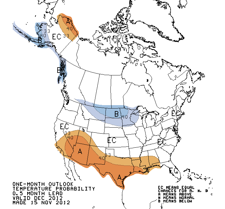
Now we can go out further and check the December and Seasonal outlooks from the
CPC. First off for December, they see nothing from any large-scale climate
factors (e.g., El Nino, La Nina, etc.) influencing our weather patterns, so
they gave us the old "Equal Chances," meaning equal chances of above-, below-
or near-normal temperatures and precipitation. We do see the odds of warmer
than normal weather starting to creep up from the south, however.
***NOTE: "EC" DOES NOT NOT NOT INDICATE A FORECAST OF NORMAL PRECIPITATION
TOTALS OR TEMPERATURE AVERAGES!!
That type of pattern correlates with the negative phase of the Pacific Decadal
Oscillation (PDO), another of those far-flung oceanic influences, or what is
known in climate circles as a "teleconnection."
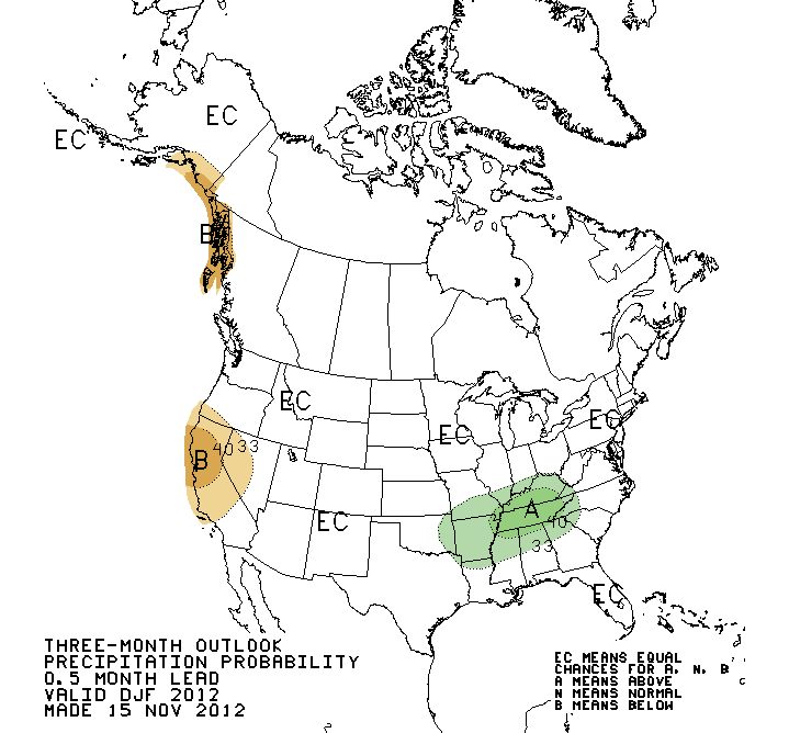
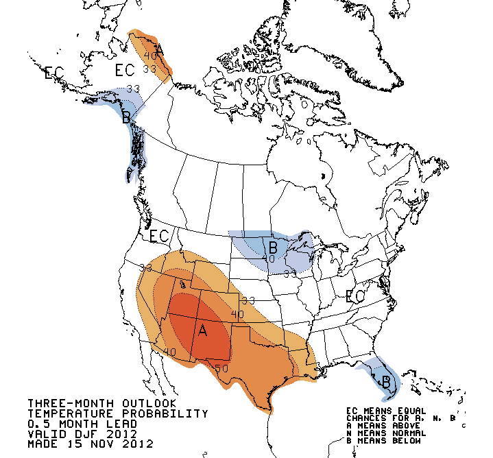
The new winter outlook (Dec-Feb) brings those chances for above normal
temperatures into the state, but also slightly increased odds of above normal
precipitation into the eastern quarter of Oklahoma.
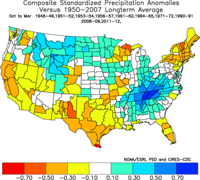
These forecasts are mostly a combination of long-range model output and the
composites of what has occurred in the past with a negative PDO and the lack
of La Nina or El Nino (otherwise known as "ENSO-Neutral"). You can see here
from those composites of precipitation where they go their bullseye over
Tennessee of wetter than normal weather. For Oklahoma, it generally means dry
weather, although the signal is not overwhelming.
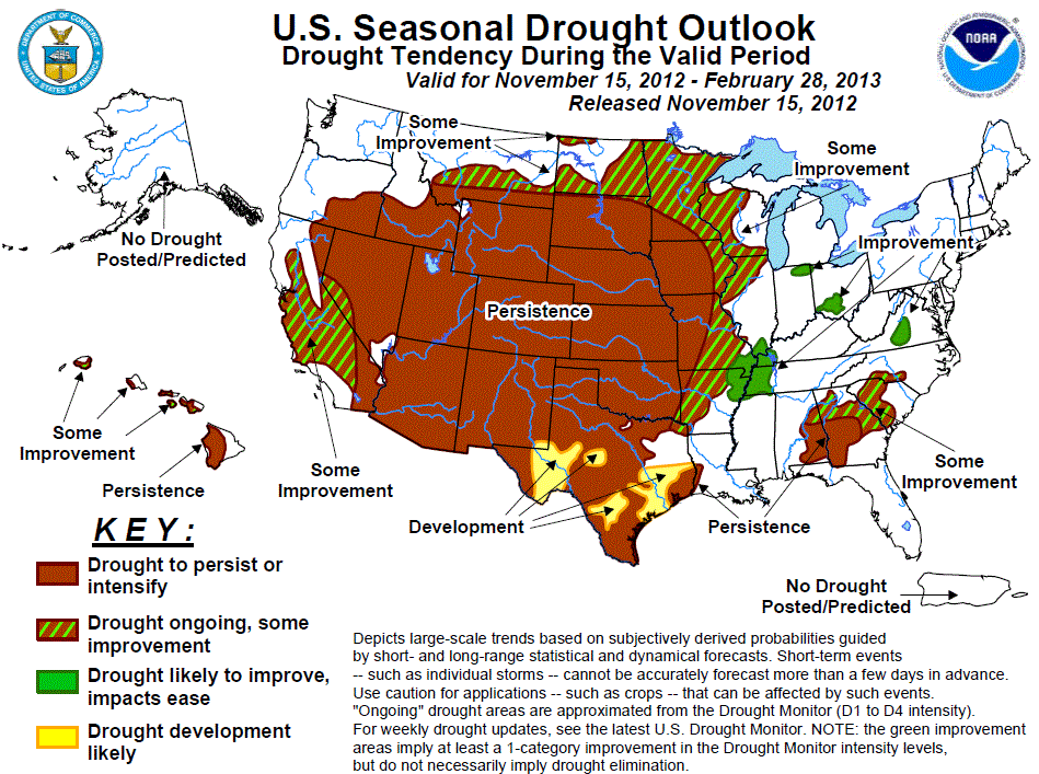
Given all of that, the new U.S. Seasonal Drought Outlook from the CPC still
has little in the way of encouragement for Oklahoma with drought persisting
or intensifying over the next few months.
I'll just give my own two cents on these forecasts. Yes, it does look dry as
we go forward, but winter is normally a dry time in Oklahoma anyway. We will
most likely still be in drought as we come out of the winter into spring. That's
when the rains will need to kick in and not give summer a headstart like we've
seen the last two years. And as we've talked about before, the wildcard with
our temperatures is the Arctic Oscillation, which has played havoc with those
huge masses of cold air over the last few winters. Should it go back to being
primarily negative like it was in 2009-10 and 2010-11, expect more frequent
bouts with frigid air. If it stays positive like last year, we might be in
for another mild winter. Unfortunately, the AO is impossible to predict more
than a couple of weeks out. It looks to remain positive for the next couple
of weeks after a negative October.
Gary McManus
Associate State Climatologist
Oklahoma Climatological Survey
(405) 325-2253
gmcmanus@mesonet.org
November 15 in Mesonet History
| Record | Value | Station | Year |
|---|---|---|---|
| Maximum Temperature | 86°F | ARNE | 2016 |
| Minimum Temperature | 8°F | KENT | 1997 |
| Maximum Rainfall | 2.71″ | BROK | 2011 |
Mesonet records begin in 1994.
Search by Date
If you're a bit off, don't worry, because just like horseshoes, “almost” counts on the Ticker website!