MESONET TICKER ... MESONET TICKER ... MESONET TICKER ... MESONET TICKER ...
November 10, 2016 November 10, 2016 November 10, 2016 November 10, 2016
Drought takes a licking
But keeps on ticking (you have to read the title of today's Ticker for this to
make sense. But of course the Ticker rarely makes sense so why bother? Anyway,
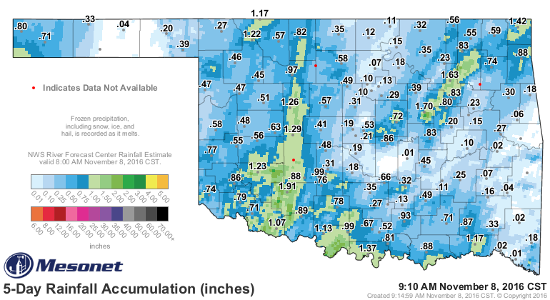
I showed you on Tuesday that the rains fell mainly on the plains of western
Oklahoma and largely missed the areas most impacted by continued drought.
http://ticker.mesonet.org/archive/20161108/5day-rain-totals.png
It did rain a bit after that, but the gist of the picture remains the same. So
not only did we see very little in the way of drought relief in those hard hit
areas, we actually saw some intensification in SE OK. Here is today's new
Drought Monitor map, as well as a one-week change map.
http://ticker.mesonet.org/archive/20161110/20161108_OK_trd.png
http://ticker.mesonet.org/archive/20161110/1week-DM-change.png
The reasoning remains sound. Despite the welcome moisture, the short- and long-
term rainfall statistics still look rather sad. For example, the 30-day statistics
are downright droughty.
http://ticker.mesonet.org/archive/20161110/last30days.stats.png
http://ticker.mesonet.org/archive/20161110/last30daystot.png
http://ticker.mesonet.org/archive/20161110/last30dayspct.png
After today's cold start, and yesterday's frigid beginning, expect a bit of a
warmup before another cold front strikes for the weekend. Following that,
another warmup will last throughout much of next week.
http://ticker.mesonet.org/archive/20161110/yesterdays-lows.png
http://ticker.mesonet.org/archive/20161110/todays-lows.png
http://ticker.mesonet.org/archive/20161110/nws-tulsa-extended.gif
http://ticker.mesonet.org/archive/20161110/nws-norman-extended.png
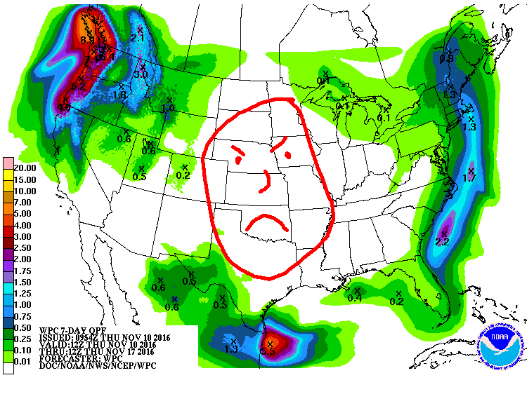
Unfortunately, the rain chances for the next 7 days are nil-to-none. A very
mean looking 7-day rainfall forecast map tells the story (yes, we got our
crayons back).
http://ticker.mesonet.org/archive/20161110/7day-precip-forecast.gif
Let's hope this changes and quick.
Gary McManus
State Climatologist
Oklahoma Mesonet
Oklahoma Climatological Survey
(405) 325-2253
gmcmanus@mesonet.org
==================================================
The OCS/Mesonet Ticker
https://ticker.mesonet.org/
To subscribe or unsubscribe from the Ticker
or for questions about the Ticker or its content
Phone or Email the Ticker Manager at OCS
Phone: 405-325-2253 Email: ticker@mesonet.org
---------------------------------------------------
-C- Copyright 2024 Oklahoma Climatological Survey
===================================================
|


 Tweet
Tweet