MESONET TICKER ... MESONET TICKER ... MESONET TICKER ... MESONET TICKER ...
November 1, 2019 November 1, 2019 November 1, 2019 November 1, 2019
October's Weather Was Frightful
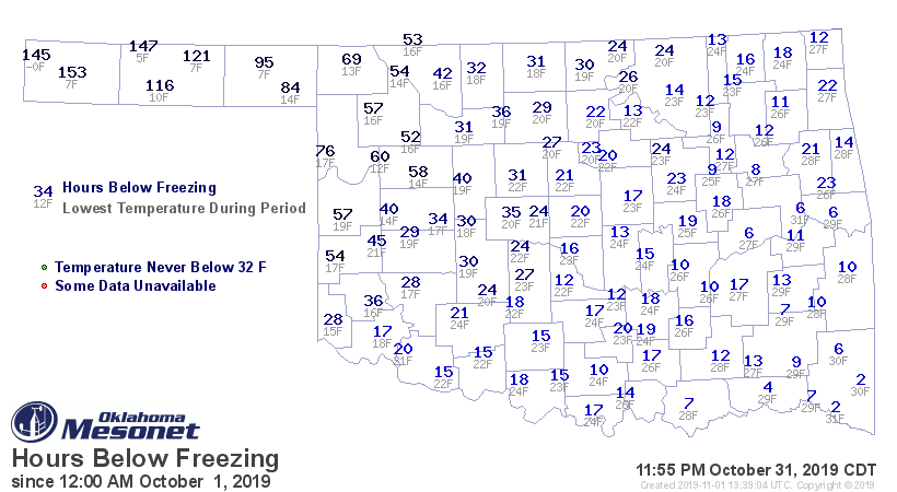
http://ticker.mesonet.org/archive/20191101/Oct-hours-below-freezing.png
Well I wish I could say I enjoyed that! Bring back the extended heat of summer
that we endured through September (and early October). As you can tell from the
hours below freezing map above, almost the entire state suffered a hard freeze
during October, and everybody received a freeze of at least a few hours. October
was one of the coldest and wettest combos on record (see below), and plenty of
records fell. We saw records for lowest temperature ever recorded during October
(and this early in the season), highest snowfall during October (and this early
in the season), and the calendar year tornado count.
October is dead, long live November...but no records, please! Here's the October
recap.
--------------------------------------------------------------------------------
Despite the season, spring and winter weather stole most of the headlines
during October. A cold front moved through the state on the sixth and dropped
temperatures below normal, where they would remain for the rest of the month.
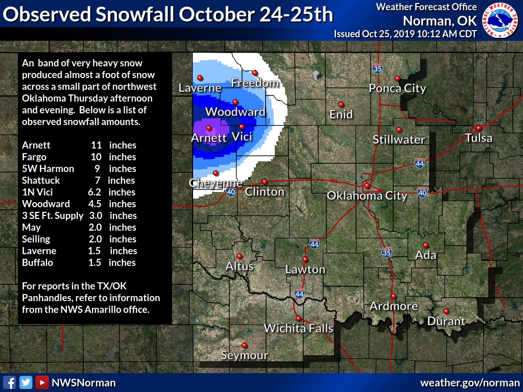
Light snow fell in the Panhandle on the 11th, but the real wintry punch was yet
to come. Over a foot of snow pounded the northwest on the 24th and 25th – a
rare October snowstorm that shattered records. Arnett’s total of 13 inches on
the 25th broke the record for highest 24-hour snow total in Oklahoma during
October, and for that early in the season. Amounts from 6-10 inches were
common.
http://ticker.mesonet.org/archive/20191101/nws-norman-snow-totals.jpg
Winter wasn’t finished breaking records, however. A powerful cold front blasted
through the state on the 28th, culminating Halloween morning with the lowest
temperature ever recorded in Oklahoma during the month of October, and for that
early in the season. Kenton dropped to zero degrees that day, besting the
previous lowest October minimum of 3 degrees at Freedom from Oct. 29, 1993.
http://ticker.mesonet.org/archive/20191101/halloween-low-temps.png
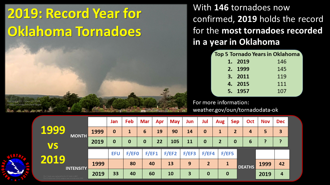
Spring stepped in on the 20th and brought an outbreak of severe weather across
eastern Oklahoma. The day saw winds of 70-80 mph, hail to the size of
baseballs, and at least six confirmed tornadoes. All the tornadoes were
considered weak – rated EF0 or EF1 on the Enhanced Fujita Scale – but damaging
nonetheless. The 2019 tornado count rose to 146, the most for any calendar year
since accurate records began in 1950, eclipsing 1999’s previous record count of
145.
http://ticker.mesonet.org/archive/20191101/nws-norman-tornado-record.png
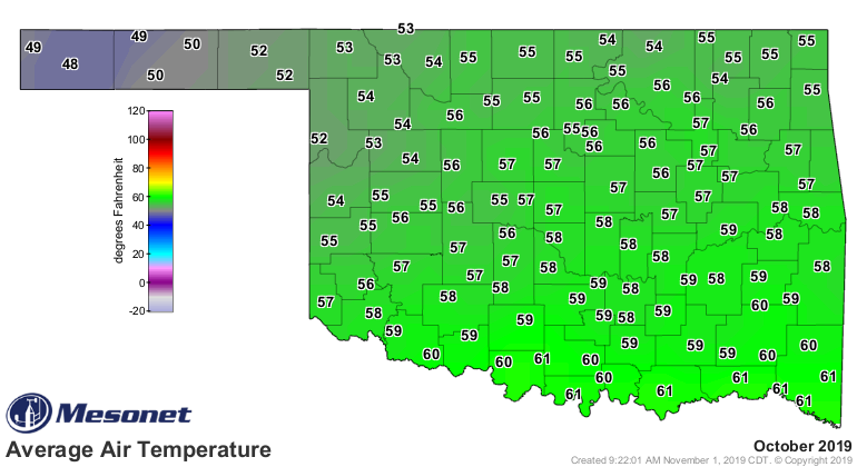
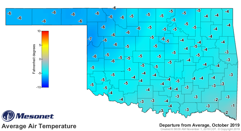
According to preliminary data from the Oklahoma Mesonet, the statewide average
temperature was 56.7 degrees, 4.2 degrees below normal and ranked as the eighth
coolest October on record.
http://ticker.mesonet.org/archive/20191101/oct-avg-temps.png
http://ticker.mesonet.org/archive/20191101/oct-temp-departure.png
Those records date back to 1895. Minimum temperature records were set or tied
during the month at Lawton, McAlester, and Oklahoma City. Low maximum
temperature records were also set or tied at Lawton and Oklahoma City.
Grandfield recorded the highest temperature of the month with 95 degrees on the
fifth. The cold October brought the January-October statewide average down to
62.9 degrees, 0.2 degrees below normal – the 61st coolest such period on record.
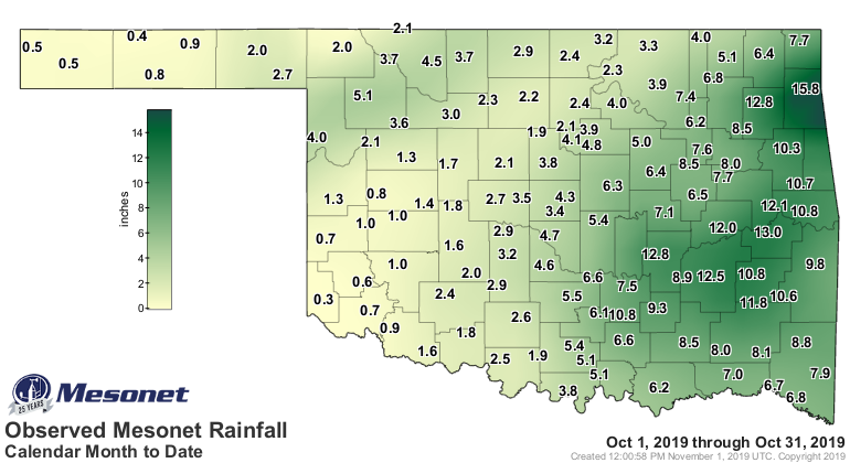
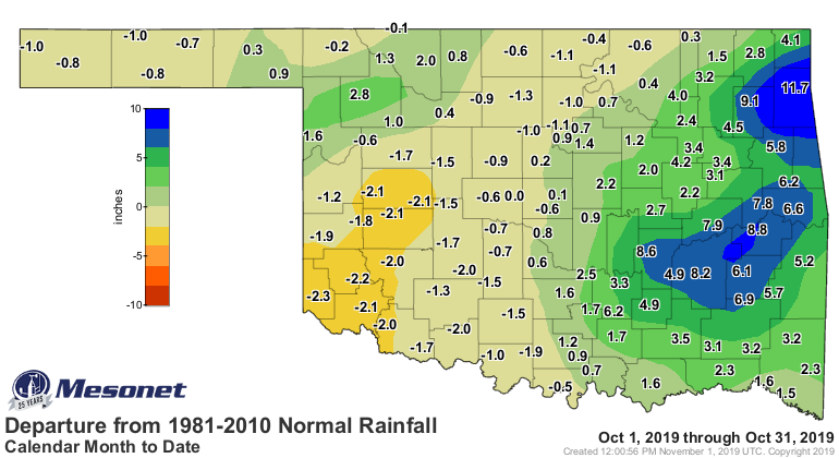
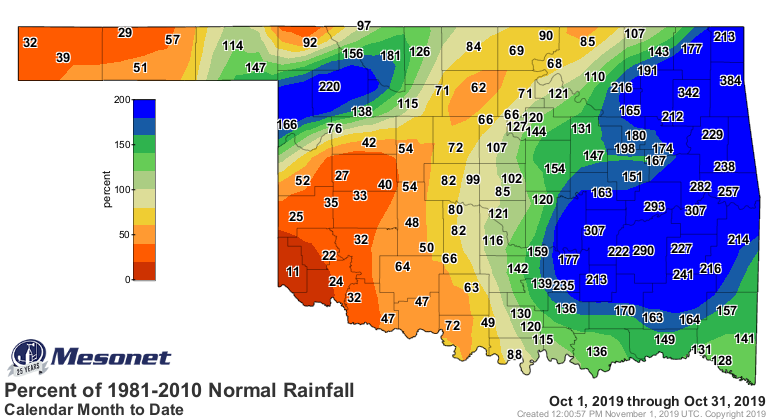
Despite a dry month in the western half of the state, October still managed to
finish with a moisture surplus thanks to tremendous rains across eastern
Oklahoma. The statewide average was 4.80 inches, 1.26 inches above normal to
rank as the 21st wettest October on record. East central Oklahoma had an
average of 10.46 inches, 6.02 inches above normal, to rank as their fourth
wettest October on record. The northeast and southeast sections experienced
their tenth and seventh wettest Octobers, respectively. Deficits across the
west generally ranged from 1-2 inches. Thirteen Mesonet sites recorded at least
10 inches of rain for the month, with Jay leading the pack at 15.8 inches.
Hollis brought up the rear with 0.28 inches, joining 12 other sites that failed
to reach at least an inch of precipitation.
http://ticker.mesonet.org/archive/20191101/oct-rain-totals.png
http://ticker.mesonet.org/archive/20191101/oct-rain-depart.png
http://ticker.mesonet.org/archive/20191101/oct-rain-pct.png
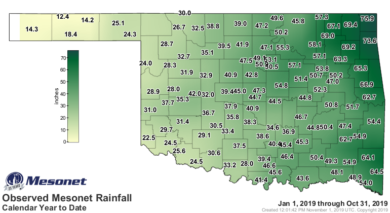
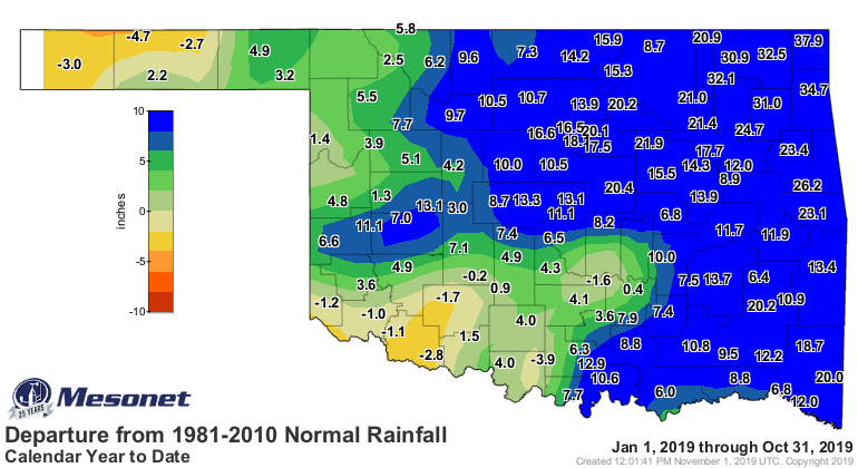
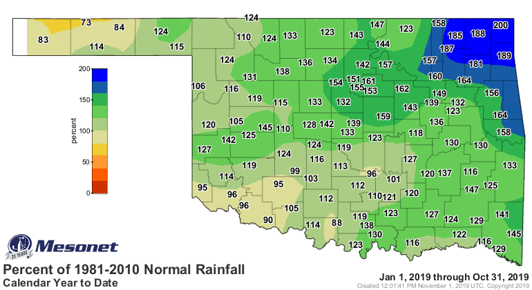
The state remained on pace to finish with one of its wettest years on record.
The statewide average was 41.54 inches, 9.61 inches above normal to rank as the
sixth wettest January-October on record. Northeast Oklahoma’s average total of
59.89 inches stood at 22.72 inches above normal, the wettest first 10 months of
the year for that corner of the state. That 10-month total also broke their
annual total record, 57.82 inches from 1973.
http://ticker.mesonet.org/archive/20191101/jan-oct-rain-totals.png
http://ticker.mesonet.org/archive/20191101/jan-oct-rain-depart.png
http://ticker.mesonet.org/archive/20191101/jac-oct-rain-pct.png
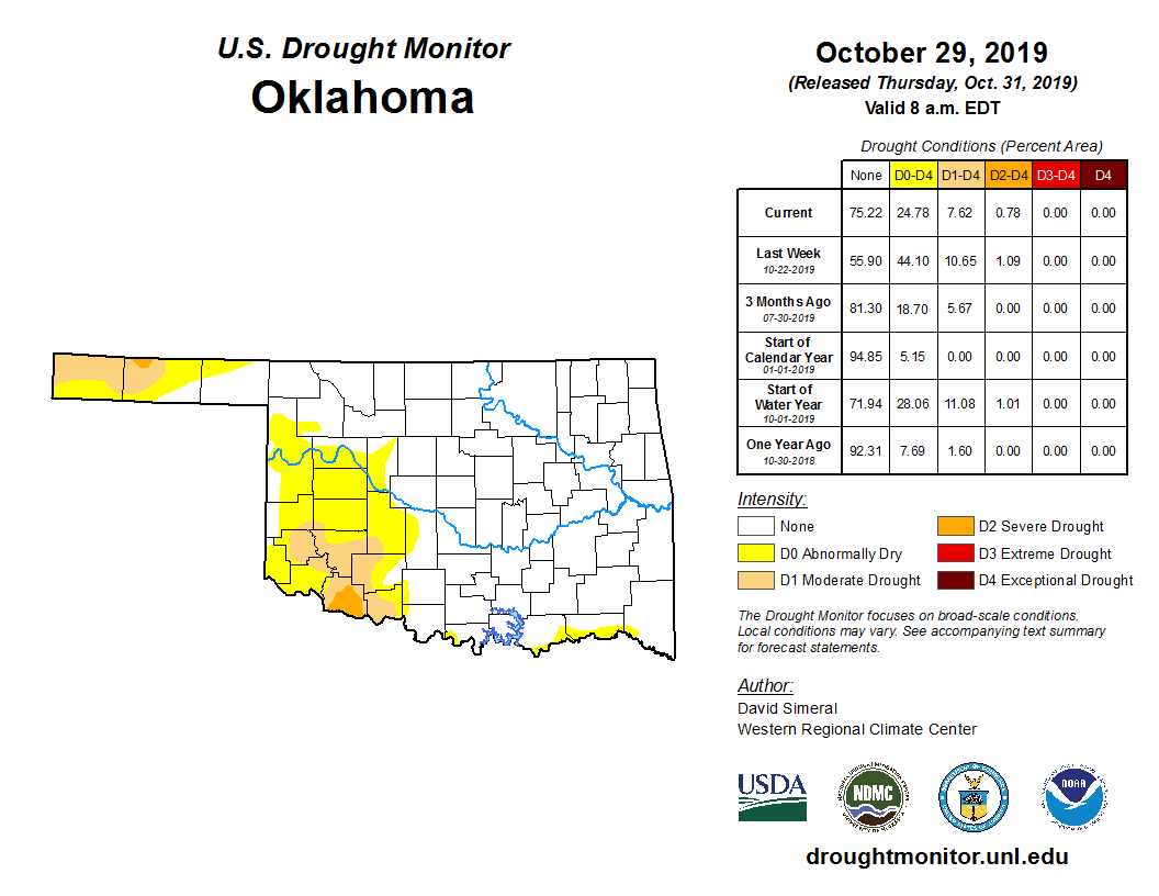
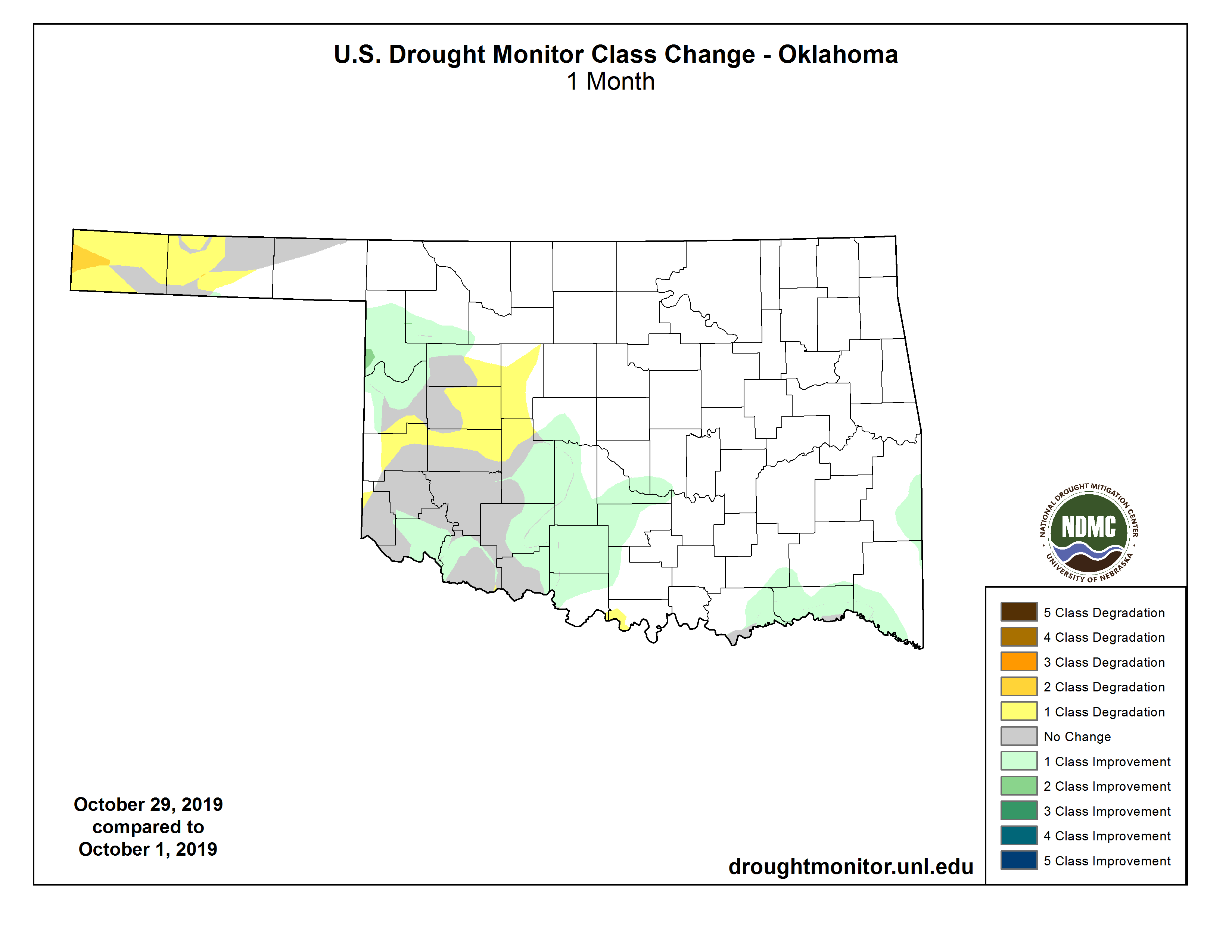
The rainfall helped improve the drought picture, and the cooler weather kept
new drought development in check. Drought coverage dropped from 11% to 8%
during October according to the U.S. Drought Monitor. Drought did manage to
spread into the western half of the Panhandle from southwest Kansas.
http://ticker.mesonet.org/archive/20191101/oct29-drought-monitor.png
http://ticker.mesonet.org/archive/20191101/4week-drought-change.png
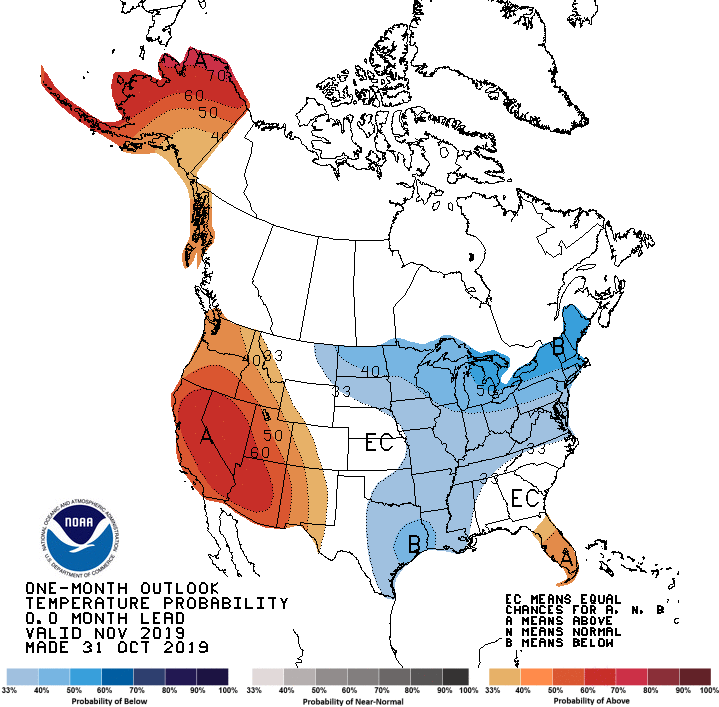
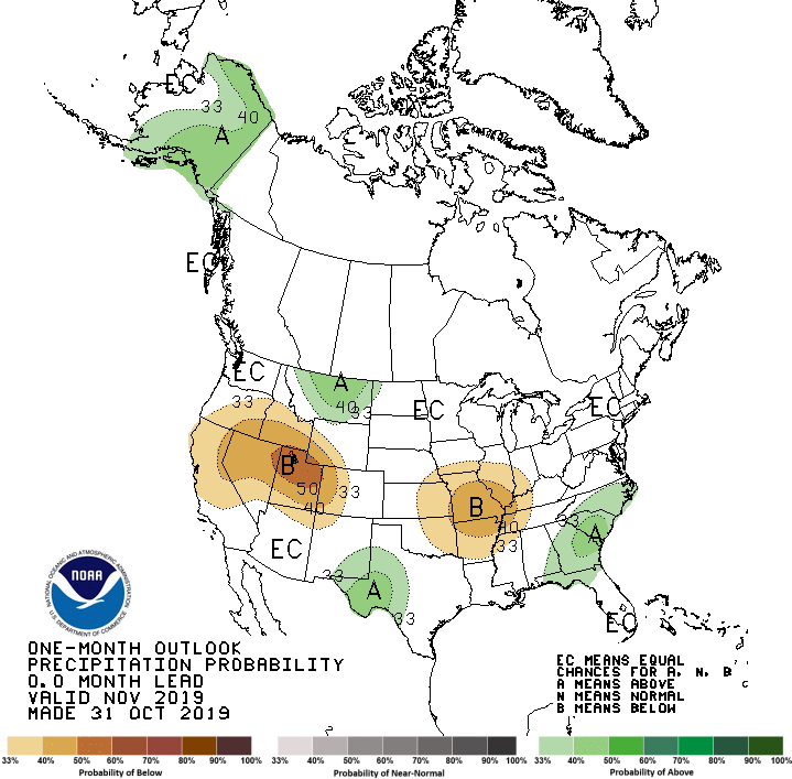
The November drought outlook from the Climate Prediction Center (CPC) holds out
hope for drought improvement in the southwest, but sees persistence of the dry
conditions in the Panhandle. CPC’s November outlooks call for below normal
temperatures and precipitation across eastern Oklahoma and equal odds of
below-, above-, and near-normal conditions over the rest of the state.
http://ticker.mesonet.org/archive/20191101/nov-drought-outlook.png
http://ticker.mesonet.org/archive/20191101/nov-temp-outlook.gif
http://ticker.mesonet.org/archive/20191101/nov-precip-outlook.gif
Gary McManus
State Climatologist
Oklahoma Mesonet
Oklahoma Climatological Survey
(405) 325-2253
gmcmanus@mesonet.org
==================================================
The OCS/Mesonet Ticker
https://ticker.mesonet.org/
To subscribe or unsubscribe from the Ticker
or for questions about the Ticker or its content
Phone or Email the Ticker Manager at OCS
Phone: 405-325-2253 Email: ticker@mesonet.org
---------------------------------------------------
-C- Copyright 2024 Oklahoma Climatological Survey
===================================================
|


 Tweet
Tweet