MESONET TICKER ... MESONET TICKER ... MESONET TICKER ... MESONET TICKER ...
October 29, 2012 October 29, 2012 October 29, 2012 October 29, 2012
A disaster of our own
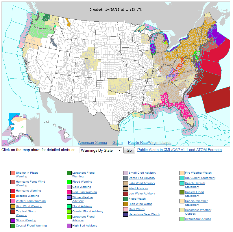
The eyes of the world are drawn to the northeastern U.S. today, and rightfully so
as a historic weather event continues to unfold. Hurricane Sandy will soon come
ashore somewhere from Virginia to New Jersey, inundating the coast with heavy
rainfall, hurricane-to-tropical storm force winds and record flooding. It's not
often you see a NWS advisory map like this, especially in late October.
http://ticker.mesonet.org/archive/20121029/nws-advisories.png
Our weather here might seem rather benign in comparison (Oklahoma's painted with
the dreaded "Hazardous Weather Outlook" colors ... ooooh, scary!), but we are
still in the midst of our own multi-billion dollar disaster, and have been for
over two years now: the drought of 2010-12.
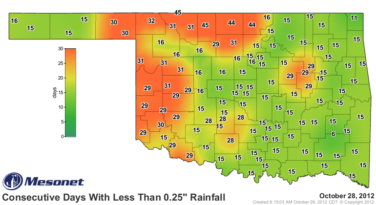
It has now been more than a month since much of NW Oklahoma has seen more than a
tenth of an inch of rainfall in a single day, and even longer since that area
has seen a quarter of an inch.
http://ticker.mesonet.org/archive/20121029/mesonet.rainfall.tenthinch.png
http://ticker.mesonet.org/archive/20121029/mesonet.rainfall.quarterinch.png
Our thoughts to those in the NE U.S., of course, but the Oklahoma wheat crop is
reaching its own disaster point. When Woods, Alfalfa, Grant, Garfield, Kay and
Noble counties go largely without rainfall in September and October, bad things
happen come harvest time.
The new Plant Available Water maps from the Oklahoma Mesonet paint a rather
bleak picture at this time. Plant available water is the amount of water (in
inches) in the soil that is potentially available for plant uptake. You can find
those maps for the 4-, 16- and 32-inch depths across the state here:
http://www.mesonet.org/index.php/weather/category/soil_moisture_temperature
The state has now dropped more than 2 inches below normal (and 35% of normal)
for the month with a statewide average of 1.1", the 20th driest Oct. 1-29 since
1921. Cherokee is still awaiting its first drop of moisture for the month, as
are several stations across western Oklahoma.
http://ticker.mesonet.org/archive/20121029/oct1-29.tots.png
http://ticker.mesonet.org/archive/20121029/oct1-29-pct.png
We are probably finished with rainfall for the month, so it's only downhill
from here. No rainfall for our area is showing up just yet through Saturday
morning, although it looks like our chances will go up directly after that with
a cold front.
http://ticker.mesonet.org/archive/20121029/5-day-rain.gif
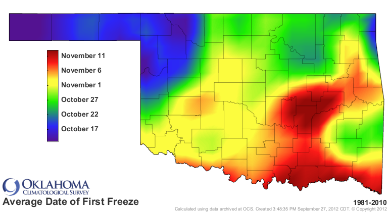
We probably saw our last gasp from the pastures that still had moisture to work
with due to the statewide freeze that occurred over the weekend. A very early
statewide freeze, as a matter of fact.
http://ticker.mesonet.org/archive/20121029/hours-below-freezing-oct25-29.png
http://ticker.mesonet.org/archive/20121029/avg_firstfreeze.1981-2010.png
We would certainly take some rain from those folks in the northeast ... hold the
hurricane impacts, however!
Gary McManus
Associate State Climatologist
Oklahoma Climate Survey
(405) 325-2253
gmcmanus@mesonet.org
==================================================
The OCS/Mesonet Ticker
https://ticker.mesonet.org/
To subscribe or unsubscribe from the Ticker
or for questions about the Ticker or its content
Phone or Email the Ticker Manager at OCS
Phone: 405-325-2253 Email: ticker@mesonet.org
---------------------------------------------------
-C- Copyright 2024 Oklahoma Climatological Survey
===================================================
|


 Tweet
Tweet