Ticker for October 19, 2023
MESONET TICKER ... MESONET TICKER ... MESONET TICKER ... MESONET TICKER ...
October 19, 2023 October 19, 2023 October 19, 2023 October 19, 2023
Soggy Pumpkins?
The Ticker is officially off today (and unofficially "a bit off" everyday), but
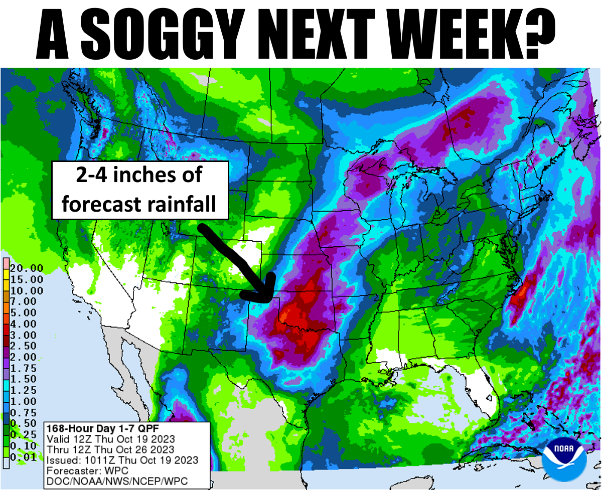
I just had to Tock about the latest forecasts. Especially the rainfall forecast
for next week. Now this is definitely an "underwear forecast," (i.e., cover your
butt), but IF we get the remnants of Hurricane Norma (hey, we knew her when she
was just a Tropical Storm), and IF that big upper-level low pressure system still
approaches from the west, and IF it slows down as forecast by some models, then
we MIGHT get some significant rainfall amounts.
That's a lot of ifs!!
Such is the nature of forecasting Mother...uhhhhh, Nature. Let's see, "such is the
nature of...", so I was trying to say it's hard to forecast for Mather Nature, but
I used "nature" earlier in the sentence. I guess it's okay.
Such is the nature of forecasting Mother Nature!
Oh to heck with it. Let's just call it all good and go from there. That rain would
be key to stop the flash drought in its tracks. It began on July 21, so it's
right at that 90-day threshold when the maps switch from 60-days and 120-days,
so tomorrow when we see a lot of rainfall drop off from northern OK (that fell
on July 21), these maps will get a whole lot uglier. As noted yesterday.


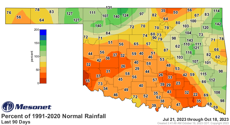
And the rain is sorely needed, AND needed sorely. We saw another large jump
in drought this week on the U.S. Drought Monitor map, and a significant portion
of that jump is in the higher intensities.


And futhermore (so serious we're dropping our r's), a bunch of that new
Abnormally Dry (D0) designation from NW through central OK is where a bunch of
that rain fell on July 21, but has been dry since then. That D0 area signifies
parts of the state that are in danger of going back into moderate (D1) drought,
so next week's possible rainfall could turn that back in a hurry.
Again, IF it happens. We've certainly had the rug pulled out from under us
enough times that the skepticism is warranted, ESPECIALLY since the big storm
system to our west is still off the coast and not sampled well. But it
definitely COULD happen.
We'll go with the hopeful scenario.
Gary McManus
State Climatologist
Oklahoma Mesonet
Oklahoma Climatological Survey
gmcmanus@mesonet.org
October 19 in Mesonet History
| Record | Value | Station | Year |
|---|---|---|---|
| Maximum Temperature | 94°F | BEAV | 2003 |
| Minimum Temperature | 17°F | NOWA | 2022 |
| Maximum Rainfall | 2.73″ | WAUR | 2016 |
Mesonet records begin in 1994.
Search by Date
If you're a bit off, don't worry, because just like horseshoes, “almost” counts on the Ticker website!