MESONET TICKER ... MESONET TICKER ... MESONET TICKER ... MESONET TICKER ...
October 19, 2017 October 19, 2017 October 19, 2017 October 19, 2017
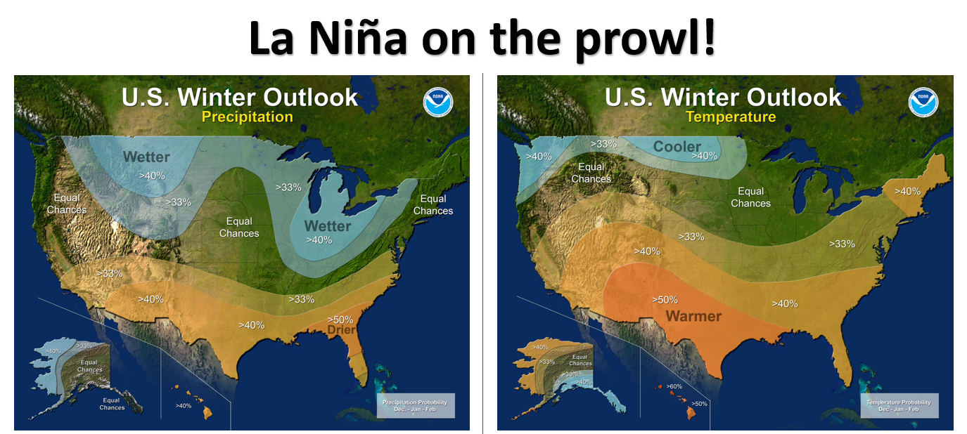
La Ni?a on the prowl
http://ticker.mesonet.org/archive/20171019/winter-outlooks.png
The National Weather Service's Climate Prediction Center released their official
winter outlook today, and for Oklahoma it appears the odds are increased for a bit
warmer weather in general. And the odds are increased for below normal
precipitation in the southern half of the state. What's that really mean for
things like snowfall, ice storms, thunderstorms and the like? Well, not much,
really. Remember, these are odds that favor (or don't favor) certain climate
patterns over a 3-month period. Significant individual weather events can occur
despite the overriding climate pattern. Think back to February 2011, for instance.
During that strong La Nina (one of the strongest on record) that began in the
fall of 2010, in the midst of the beginning months of the worst drought the state
has seen since the 1950s...we set records for the lowest temperature ever recorded
in the state (Nowata Mesonet, -31 degrees), and the highest 24-hour snowfall event
in state history (27 inches at Spavinaw).
Now this winter outlook is being influenced by the growing threat of La Nina, the
associated sea surface temperature and atmospheric changes in the equatorial
pacific that, along with El Nino make up the El Nino/Southern Oscillation. There
is a third component when El Nino and La Nina are absent, aptly titled "Neutral
Conditions." In the case of La Nina, those waters in the eastern equatorial
pacific cool and with the associated atmospheric changes, impact weather around
the world. For our little corner of the earth, the tendency is for drier and
warmer than normal weather during the cool season (let's say October-ish through
April-ish). But especially during the height of the cool season, or winter.
http://ticker.mesonet.org/archive/20171019/la.nina.impacts.png
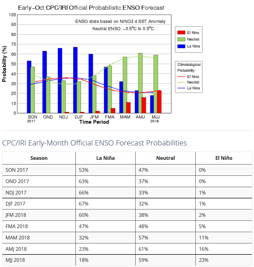
The concern for La Nina is enough that CPC issued a La Nina watch during
September, meaning the conditions are favorable within the next 6 months for
La Nina development. In this case, within the next month it would appear. The
odds for La Nina development rise to nearly 70% within the December-February
time frame.
http://ticker.mesonet.org/archive/20171019/ENSO-probabilistic-forecast.png
Now there are still some mixed signals as to the strength of the La Nina (i.e.,
the "colder" those waters get, the "stronger" the La Nina), but here is the
OFFICIAL word:
?If La Nina conditions develop, we predict it will be weak and
potentially short-lived, but it could still shape the character
of the upcoming winter,? said Mike Halpert, deputy director of NOAA?s
Climate Prediction Center. ?Typical La Nina patterns during winter
include above average precipitation and colder than average
temperatures along the Northern Tier of the U.S. and below normal
precipitation and drier conditions across the South.?
Now back to that "climate vs. weather" theme, please keep in mind that ENSO (El
Nino or La Nina...or even Neutral Conditions) is only one factor, but as climate
factors go, it's one of the more easily predictable. Other factors that can
impact our winter climate and weather include the Arctic Oscillation and the
North Atlantic Oscillation, which can influence the number of arctic air masses
that penetrate deep into the U.S. and are very difficult to forecast more than
a week or two in advance.
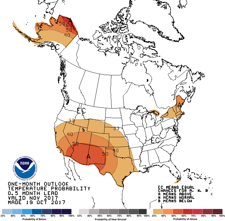
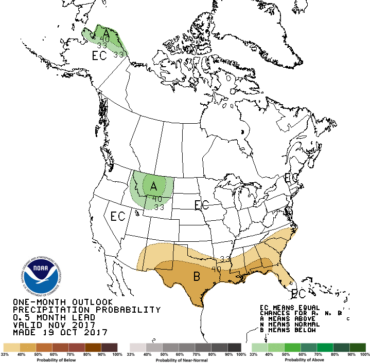
CPC also released their November outlooks today, as well as their Seasonal
Drought Outlook.
http://ticker.mesonet.org/archive/20171019/november-temp-outlook.gif
http://ticker.mesonet.org/archive/20171019/nov-precip-outlook.gif
The November outlooks are just beginning to show the influence of La Nina, with
warmer than normal weather favored across the Desert Southwest and Oklahoma, and
drier than normal weather across the SW third of the state.
As with most things, including BBQ, questions about the basement in the Alamo,
and ENSO influences, Texas tends to be more greatly impacted.
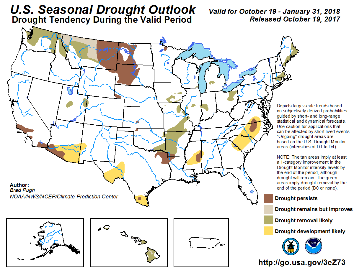
Drought relief is expected across the SE corner of the state.
http://ticker.mesonet.org/archive/20171019/season_drought_outlook.png
Let's bring it back closer to the present. Since I've already bored you to
death with talk of winter and all this ENSO stuff, let's look at the next few
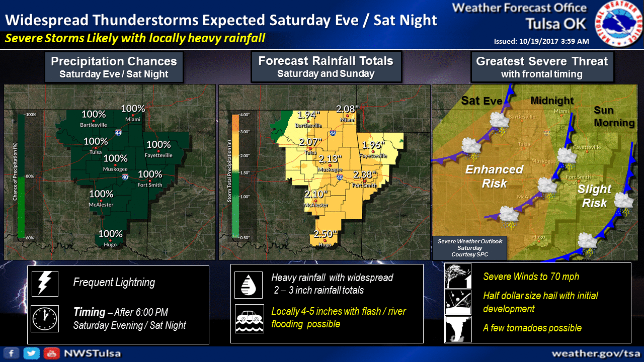
days. Watch for a continued warm up over the next couple of days, culminating
on Saturday with a cold front, a chance of storms...some of which could be
severe! Much of the eastern half of the state will be under at least an
"enhanced" threat of severe weather.
http://ticker.mesonet.org/archive/20171019/nws-norman-svr.png
http://ticker.mesonet.org/archive/20171019/nws-tulsa-svr.png
ALL MODES OF SEVERE WEATHER WILL BE POSSIBLE! The tornado threat doesn't
appear to be too great, but hey, this is Oklahoma. That should be an official
forecast term.
"But hey, this is Oklahoma!"
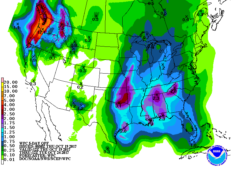
The heaviest rains appear to be across the southeast, exactly where they are
needed, given the U.S. Drought Monitor report released this morning.
http://ticker.mesonet.org/archive/20171019/5day-rain-forecast.gif
http://ticker.mesonet.org/archive/20171019/20171017_OK_trd.png
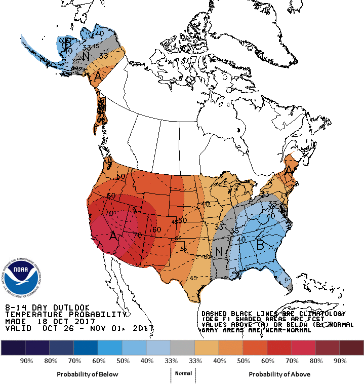
Looks like that might have to last us for awhile, given the medium-range CPC
outlooks, which favor drier and warmer weather.
http://ticker.mesonet.org/archive/20171019/oct26-nov1-temp-outlook.gif
http://ticker.mesonet.org/archive/20171019/oct26-nov1-precip-outlook.gif
Okay, given all that, now digested, let me just tell you this.
No, I don't have a clue about how much snow we will get this winter. I know
you were still thinking about that. So was I.
Gary McManus
State Climatologist
Oklahoma Mesonet
Oklahoma Climatological Survey
(405) 325-2253
gmcmanus@mesonet.org
==================================================
The OCS/Mesonet Ticker
https://ticker.mesonet.org/
To subscribe or unsubscribe from the Ticker
or for questions about the Ticker or its content
Phone or Email the Ticker Manager at OCS
Phone: 405-325-2253 Email: ticker@mesonet.org
---------------------------------------------------
-C- Copyright 2024 Oklahoma Climatological Survey
===================================================
|


 Tweet
Tweet