MESONET TICKER ... MESONET TICKER ... MESONET TICKER ... MESONET TICKER ...
October 5, 2012 October 5, 2012 October 5, 2012 October 5, 2012
El Ni-No?
What started out as a joke has turned into a disaster! No, wait, that was when
Rocky fought Thunderlips (this is how my wife wakes me up in the morning, by
the way).
http://ticker.mesonet.org/archive/20121005/thunderlips.jpg
Let's start over. What started out looking inevitable is now looking like an
equatorial pacific dud. El Nino has been predicted to develop ever since early
summer, and for awhile, that prediction looked golden. But forecasters at the
NWS' Climate Prediction Center (CPC) are starting to hedge their bets, as
discussed in the October ENSO Diagnostic Discussion released yesterday.
"Compared to the past few months, the chance is reduced for El Ni?o
to develop during Northern Hemisphere fall/winter 2012-13. Due to
the recent slowdown in the development of El Ni?o, it is not clear
whether a fully coupled El Ni?o will emerge. The majority of models
indicate that borderline ENSO-neutral/ weak El Ni?o conditions will
continue, and about half suggest that El Ni?o could develop, but
remain weak. The official forecast therefore favors the continuation
of borderline ENSO-neutral/ weak El Ni?o conditions into Northern
Hemisphere winter 2012-13, with the possibility of strengthening
during the next few months.
ENSO stand for "El Nino/Southern Oscillation," the phenomenon that sees changes
in Sea Surface Temperatures and air patterns in the equatorial pacific, which
can then change weather patterns across the world. La Nina has dominated ENSO
over the last couple of years, and many experts point to that as one of the
factors in our two-year cycle of drought and heat, especially in the Southern
Plains. Infamous by now, La Nina can bring warmer and drier cool-season (let's
say October-March/April) weather patterns across the southern tier of the U.S.
Conversely, El Nino can provide much of that same area cooler and wetter
weather patterns. The caveat, of course, is that they don't always behave or
impact weather patterns as they should. Not a shock considering how many other
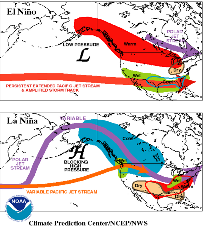
factors impact global-to-regional-to-local weather patterns. But, on average,
here's a quick graphic showing what the cold and warm phases of ENSO can do.
http://ticker.mesonet.org/archive/20121005/ENSO-impacts.jpg
So it's obvious why folks in the Southern Plains would look forward to a warm
ENSO event, since it can lead to wetter and cooler weather for this area of
the world. Being in a fairly nasty two-year drought cycle will do that to ya.
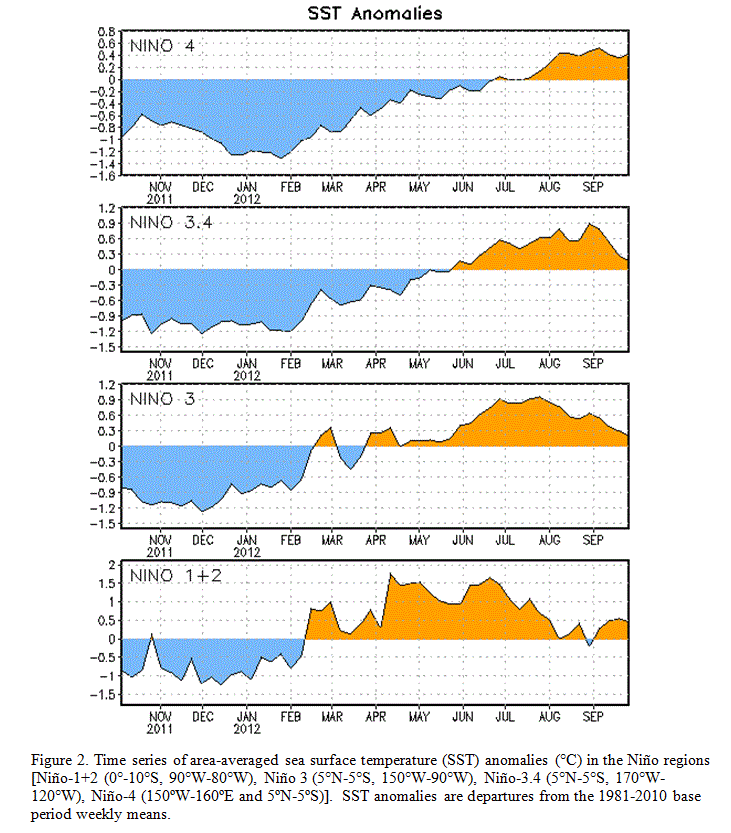
The warm anomalies off the west coast of South America started to diminish at a
time they should be holding steady or increasing (in the case of a developing
El Nino). You can see the transition from La Nina to ENSO-neutral conditions
last spring and eventually to the warm anomalies that would signify El Nino in
this graphic from the CPC. Pay particular attention to the Nino 3.4 region on
the second graph, a key ENSO (El Nino/Southern Oscillation) indicator.
http://ticker.mesonet.org/archive/20121005/SST-anomalies.gif
That drop in the temperature anomaly on the right side of the graph does not
bode well for El Nino, especially a moderate-to-strong event, which would have
a greater chance to impact Oklahoma. A table of probability for each event over
the next year tells the story. This comes from the International Research
Institute for Climate and Society (IRI), which partners with CPC in producing
the ENSO outlooks.
-****-
Season La Ni?a Neutral El Ni?o
SON 2012 ~0% 45% 55%
OND 2012 1% 45% 54%
NDJ 2013 2% 46% 52%
DJF 2013 3% 49% 48%
JFM 2013 4% 55% 41%
FMA 2013 7% 59% 34%
MAM 2013 12% 64% 24%
AMJ 2013 16% 63% 21%
MJJ 2013 19% 57% 24%
-***-
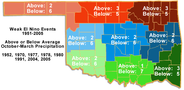
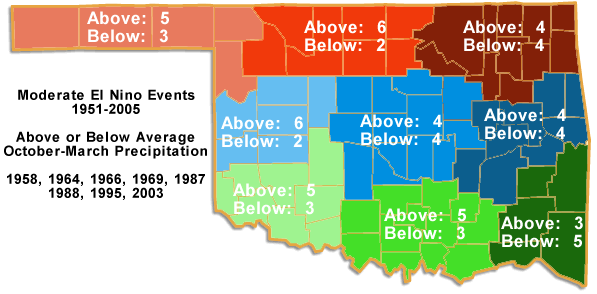
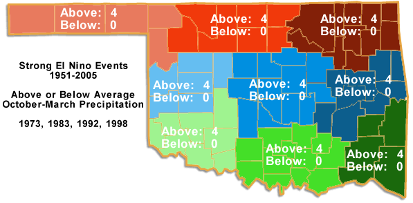
As it stands now, Oklahoma should probably be hoping for ENSO-neutral conditions
to take over, since past rainfall data suggests a weak El Nino would up the
odds for more dry weather in the state.
http://ticker.mesonet.org/archive/20120822/weak_ok_cd.png
http://ticker.mesonet.org/archive/20120822/moderate_ok_cd.png
http://ticker.mesonet.org/archive/20120822/strong_ok_cd.png
All hope is not lost, according to the forecasters. The El Nino could still
strengthen to a moderate/strong event with a good batch of convective activity
along the equator. That would help boost the westerly winds of that region and
keep the warm water bunched up along the South American coast. Even if that
doesn't occur, and we do see a weak El Nino come to the forefront this winter,
there is no guarantee that it will mean dry weather for us. Last year's La Nina
presided over one of our wettest cool seasons in recent memory.
This ENSO episode has already gone against convention. No reason why it would
stop now.
El Nino? Heck if I El Know?
Gary McManus
Associate State Climatologist
Oklahoma Climatological Survey
(405) 325-2253
gmcmanus@mesonet.org
==================================================
The OCS/Mesonet Ticker
https://ticker.mesonet.org/
To subscribe or unsubscribe from the Ticker
or for questions about the Ticker or its content
Phone or Email the Ticker Manager at OCS
Phone: 405-325-2253 Email: ticker@mesonet.org
---------------------------------------------------
-C- Copyright 2024 Oklahoma Climatological Survey
===================================================
|


 Tweet
Tweet