MESONET TICKER ... MESONET TICKER ... MESONET TICKER ... MESONET TICKER ...
September 9, 2010 September 9, 2010 September 9, 2010 September 9, 2010
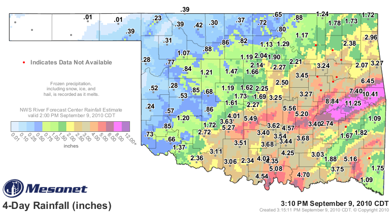
Hermine dumped a bunch of rain on the state - in some places, way too much. But
in all, for most of the southeastern two-thirds of Oklahoma it was a great
soaking rainfall, just the kind needed to recharge the soil moisture and water
table.
Here are the top 20 rainfall amounts from the Oklahoma Mesonet
due to Hermine:
Stigler 11.25 Madill 5.08
Sallisaw 10.41 Durant 4.70
Eufaula 8.84 Ada 4.57
Webbers Falls 7.40 Burneyville 4.54
Cookson 6.45 Ardmore 4.35
Bowlegs 5.56 Tishomingo 4.25
Washington 5.49 Newport 4.03
Acme 5.27 Chickasha 4.01
Holdenville 5.20 Hugo 3.75
Cloudy 5.15 Hectorville 3.71
Map view:
http://ticker.mesonet.org/archive/20100909/rainrfc.96hr.png
To watch Hermine in action, you can either follow the radar or the pressure ... or
both (right-click and download first for speedier viewing)!
http://ticker.mesonet.org/archive/20100909/earl.mov
Gary McManus
Associate State Climatologist
Oklahoma Climatological Survey
(405) 325-2253
gmcmanus@mesonet.org
==================================================
The OCS/Mesonet Ticker
https://ticker.mesonet.org/
To subscribe or unsubscribe from the Ticker
or for questions about the Ticker or its content
Phone or Email the Ticker Manager at OCS
Phone: 405-325-2253 Email: ticker@mesonet.org
---------------------------------------------------
-C- Copyright 2024 Oklahoma Climatological Survey
===================================================
|


 Tweet
Tweet