MESONET TICKER ... MESONET TICKER ... MESONET TICKER ... MESONET TICKER ...
August 30, 2018 August 30, 2018 August 30, 2018 August 30, 2018
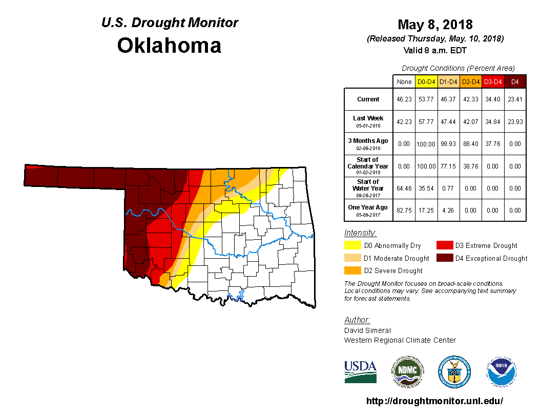
The Incredible Shrinking Drought
http://ticker.mesonet.org/archive/20180830/20180508_ok_trd.gif
We're getting there! Slowly but surely, we are reducing drought in Oklahoma with
each successive rainfall (as you can see in the animated gif of the last 17
U.S. Drought Monitor maps). We went from 42% of the state in at least severe
drought (with 23% in exceptional drought, the worst category) back on May 8, to
only 19% in a least severe drought on Aug. 28 (and no exceptional drought in
sight).
We've had a heckuva'n August thus far for MOST of the state (yes, SW OK, we see
you down there).
http://ticker.mesonet.org/archive/20180830/Aug1-29-totals.png
http://ticker.mesonet.org/archive/20180830/Aug1-29-depart-normal.png
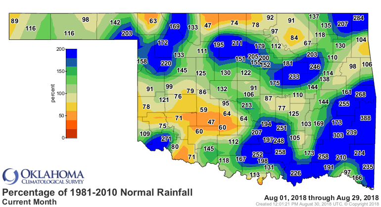
http://ticker.mesonet.org/archive/20180830/Aug1-29-pct-normal.png
We're not going to end up with the wettest August on record, but somewhere in the
top-20. Not bad!
http://ticker.mesonet.org/archive/20180830/aug1-30-stats.png
And a lot of the relief over that time frame is thanks to a swath of above
normal rains from the Panhandle down through central and southeastern Oklahoma
through the summer.
http://ticker.mesonet.org/archive/20180830/summer-rains.png
http://ticker.mesonet.org/archive/20180830/summer-rain-departures.png
http://ticker.mesonet.org/archive/20180830/summer-rain-pcts.png
We go from the good (22.3 inches at Wister) to the bad (4.4 inches at Hollis,
Tipton and Waurika).
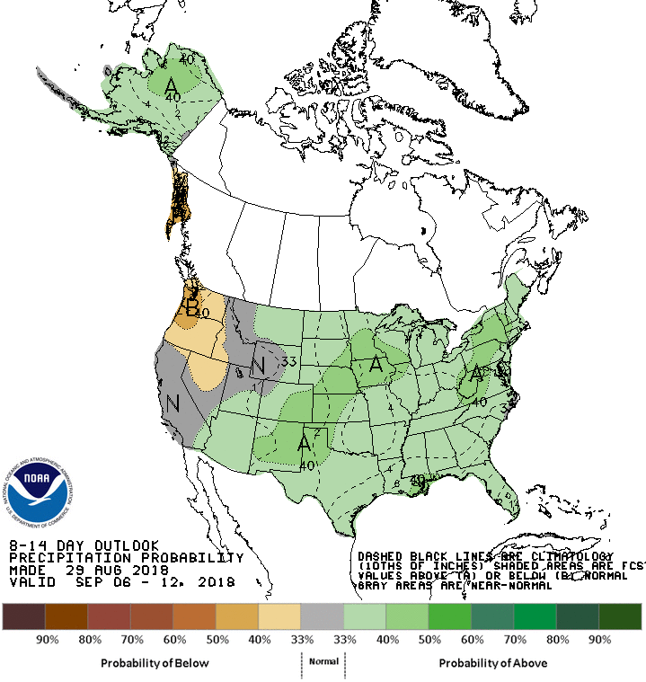
What we need are targeted rains AND another cooldown. So how about those areas
of drought in the SW and NE? What are their hopes for rain in the next week?
Well, not bad, but not enough, unfortunately. Most of the good rains will
impact the Panhandle and far NW OK, at least according to the latest 7-day
forecast.
http://ticker.mesonet.org/archive/20180830/7day-rain-forecast.gif
Hopefully that can shift to the east just a bit, but anything would be
appreciated, I'm sure. Maybe better chances next week?
http://ticker.mesonet.org/archive/20180830/sept6-12-precip-outlook.gif
Regardless of rain chances later this weekend or into next week, it's gonna be
HOT before we get there. It's gonna be steamy here for the next several days,
so be prepared for the heat.
http://ticker.mesonet.org/archive/20180830/NWS-heat-safety.png
Gary McManus
State Climatologist
Oklahoma Mesonet
Oklahoma Climatological Survey
(405) 325-2253
gmcmanus@mesonet.org
==================================================
The OCS/Mesonet Ticker
https://ticker.mesonet.org/
To subscribe or unsubscribe from the Ticker
or for questions about the Ticker or its content
Phone or Email the Ticker Manager at OCS
Phone: 405-325-2253 Email: ticker@mesonet.org
---------------------------------------------------
-C- Copyright 2024 Oklahoma Climatological Survey
===================================================
|


 Tweet
Tweet