MESONET TICKER ... MESONET TICKER ... MESONET TICKER ... MESONET TICKER ...
August 25, 2022 August 25, 2022 August 25, 2022 August 25, 2022
Great?
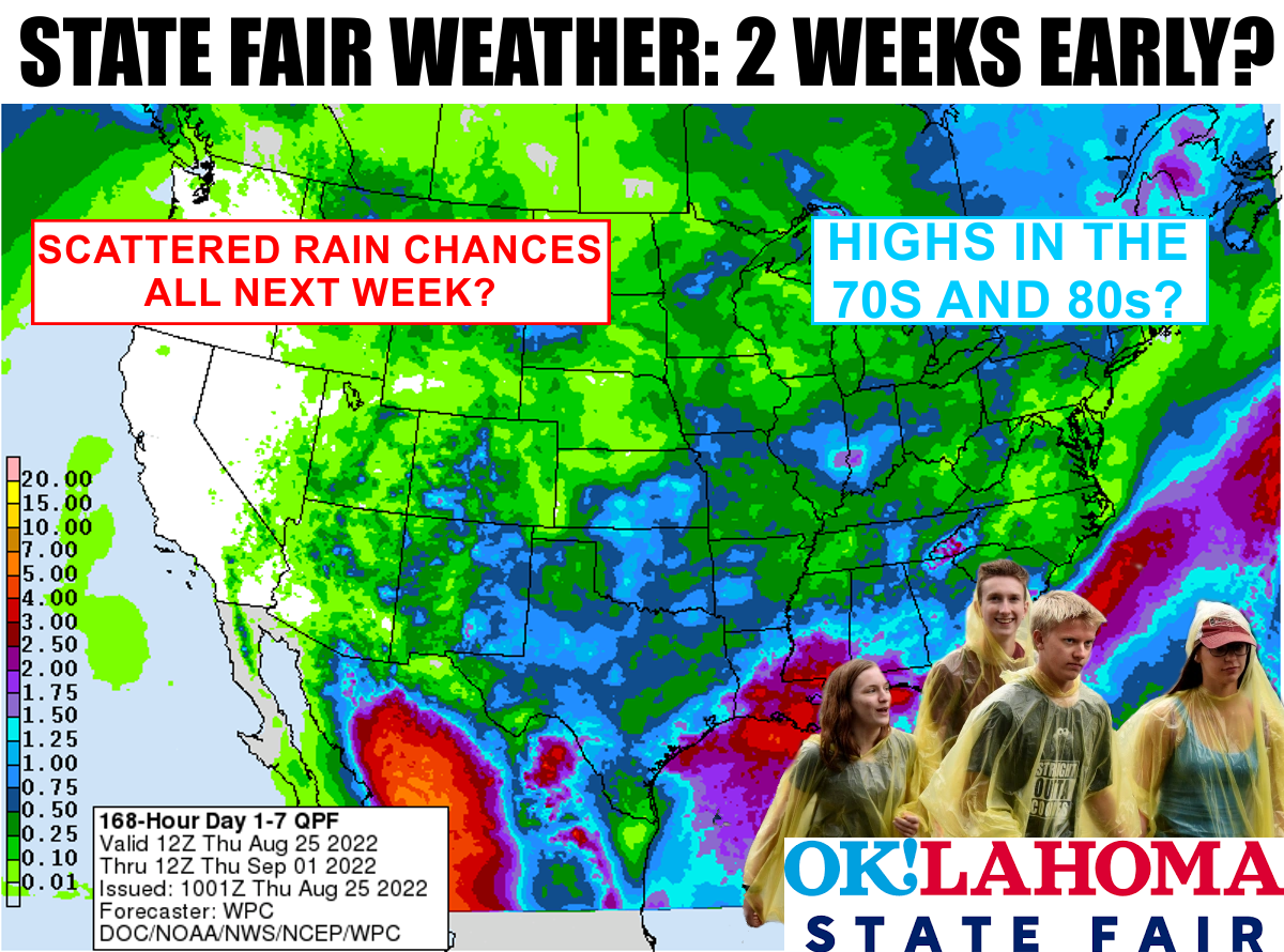
https://ticker.mesonet.org/archive/20220825/7day-rain-forecast.png
I must be doing things wrong...
Go ahead, continue with your list...I'll wait.
Finished?
Okay, so I must be doing things wrong. Every time I've been to the State Fair,
it's always 6000 degrees in full sun and people are grasping for any slice of
shade they can get.
Wait a minute...I'm now getting word that the State Fair is open at night. Ahhh,
I wish I had known that earlier. But the lore, as we've Ticked about many times,
is that the State Fair often ushers in rainy (and sometimes cooler) weather. There
is some science behind that, of course. Fall is our secondary rainy season as the
jet stream begins to meander down our way again as the sun's path heads south after
its normal northward vacation during the summer. The truth is obviously more
complicated than that, as persistent weather patterns can often mean the
aforementioned (English to Okie dictionary: "the stuff I talked about before")
days of 6000 degrees and full sun can often rule for long periods during the
State Fair. But it is difficult to go a full two weeks in Oklahoma without
day-to-day weather changes. So chances are, yes, there will be rain during
the State Fair in mid-September, and even some pretty big differences in
temperature.
At any rate, as my above graphic shows, there does appear to be a pretty good
chance of active weather next week. As usual, there are some pretty big
differences in the forecast models with one going with a persistent low pressure
system over our area, which would mean more "socked in" weather with good rain
chances, at least for scattered rains, throughout next week. The other
solutions show the dreaded heat dome trying to inch its way back, but in lesser
form.
I'm going with the more optimistic version with rain and cooler weather. I
think that's how it has been trending, so we'll see. Rain chances should start
Saturday up in the NW and trend eastward across northeastern OK on Sunday.
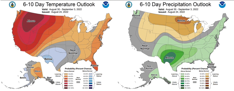
Then we'll see. The CPC outlooks are still showing seasonal to below normal
temp chances with above normal rain chances further out next week.
https://ticker.mesonet.org/archive/20220825/aug30-sept3-outlooks.png
Other than that, the drought continues full force across northern Oklahoma, but
at least the folks down south saw some relief. It wasn't too long ago that the
roles were reversed. What we need to do is get some good statewide rains for
all-around relief.
https://ticker.mesonet.org/archive/20220825/20220823_ok_trd.png
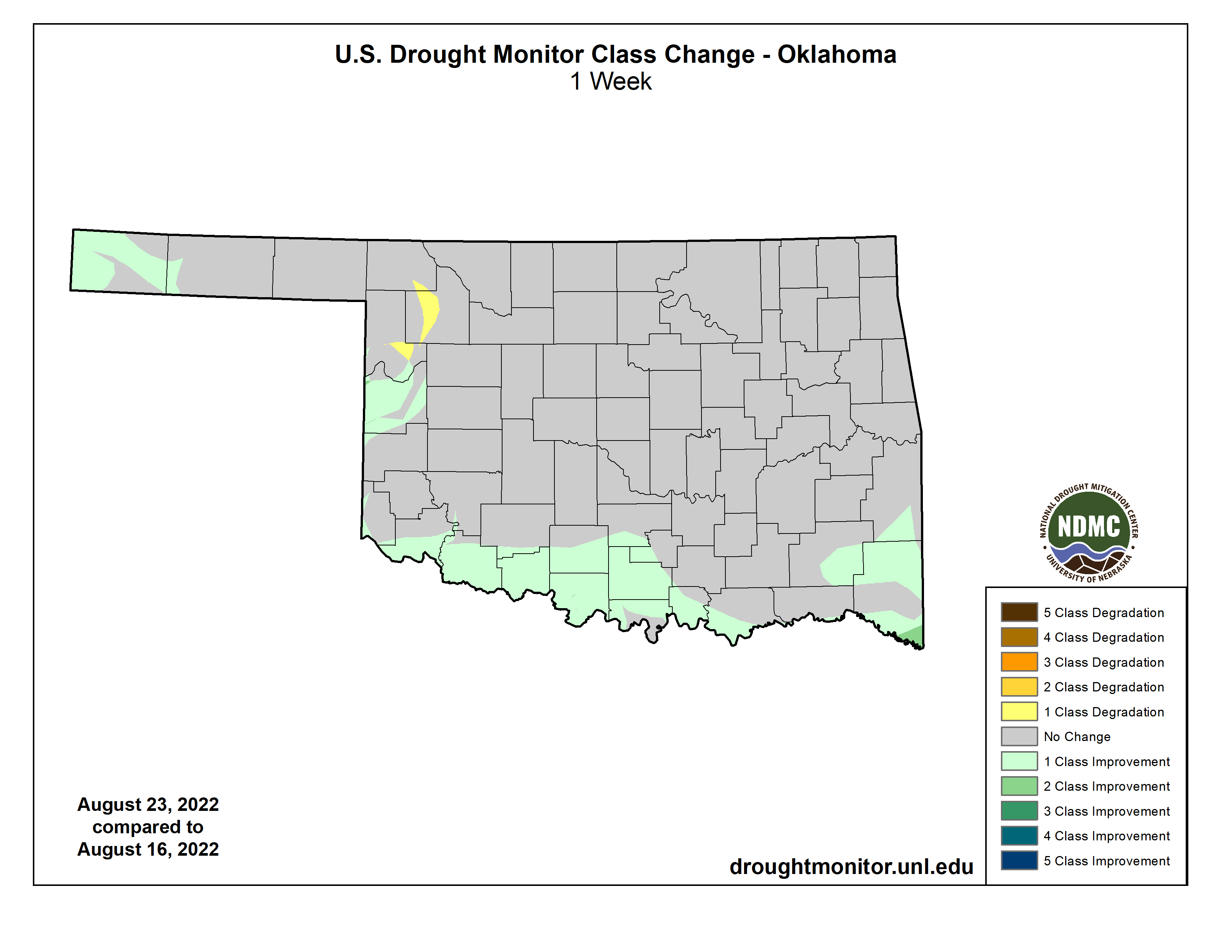
https://ticker.mesonet.org/archive/20220825/DM-change-1week.png
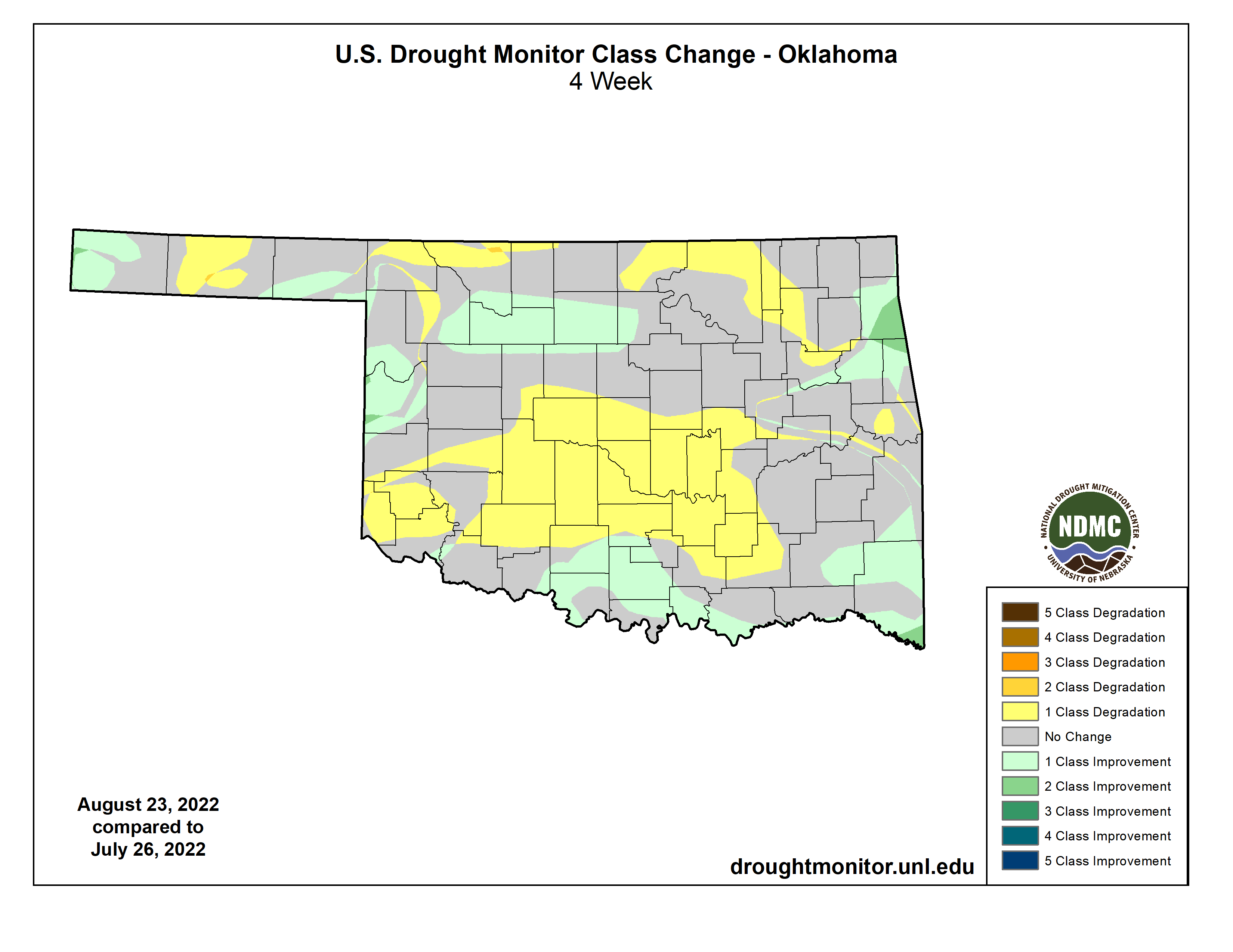
https://ticker.mesonet.org/archive/20220825/DM-change-4weeks.png
The Drought Monitor still reflects the combination of the abundant rainfall
over the last week over southern and west central Oklahoma, generally, vs. the
long-term deficits of the drought conditions that began nearly a year ago. And
of course some areas are dealing with both the flash drought that got its start
on June 11 as well as the longer term deficits of the past year. That and the
Drought Monitor's built-in fail-safe of not making abrupt 2-category changes
up or down a regular thing mean SOME changes, but not widescale moves, down
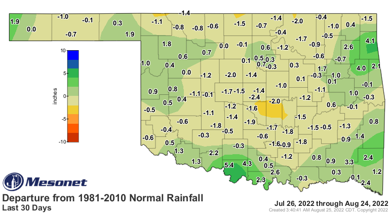
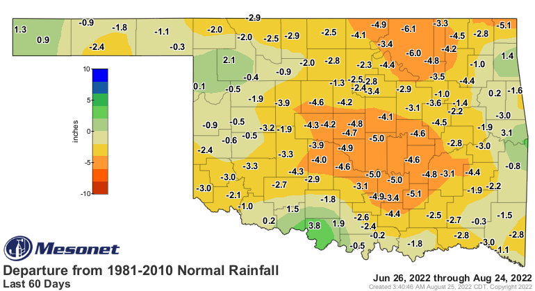
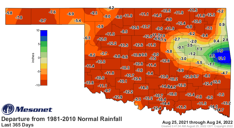
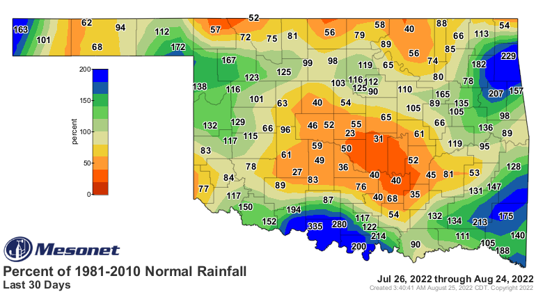
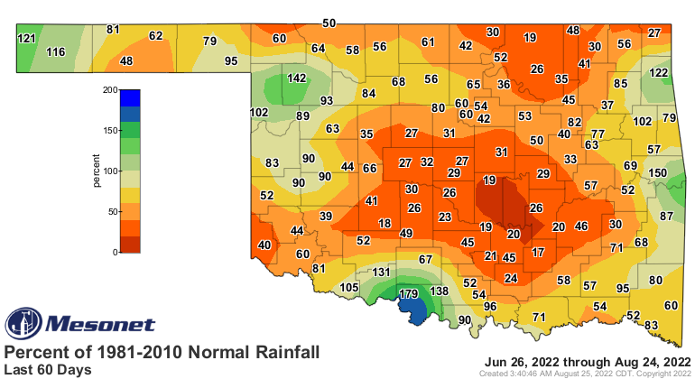
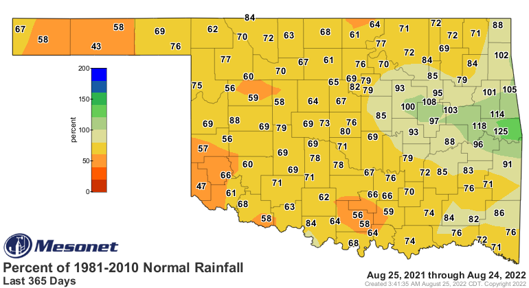
south. Take a look at our rainfall deficits of 30/60 days and those of the past
365 days. We will throw in the percent of normal maps for the same time frame
because a 6-inch deficit in the Panhandle is not the same as a 6-inch deficit
in SE OK.
https://ticker.mesonet.org/archive/20220825/del30day_rain.current.png
https://ticker.mesonet.org/archive/20220825/del60day_rain.current.png
https://ticker.mesonet.org/archive/20220825/del365day_rain.current.png
https://ticker.mesonet.org/archive/20220825/pct30day_rain.current.png
https://ticker.mesonet.org/archive/20220825/pct60day_rain.current.png
https://ticker.mesonet.org/archive/20220825/pct365day_rain.current.png
So if you look at the 30-day maps, you might say that the drought is over in
southern Oklahoma. But looking at those longer term maps, maybe not! That's why
it takes dullard types like climatologists to look at these things sometimes,
to not be attracted to the bright shiny things, like 30-day rainfall, without
taking the more boring long-term statistics into account.
Anyway, it's now up to Mother Nature to decide where to go...HOT next week with
some rain chances, or COOL with lots of rain chances.
All complaints are welcomed and can be directed to our Complaint Department...
that brick wall over there.
Gary McManus
State Climatologist
Oklahoma Mesonet
Oklahoma Climatological Survey
gmcmanus@mesonet.org
==================================================
The OCS/Mesonet Ticker
https://ticker.mesonet.org/
To subscribe or unsubscribe from the Ticker
or for questions about the Ticker or its content
Phone or Email the Ticker Manager at OCS
Phone: 405-325-2253 Email: ticker@mesonet.org
---------------------------------------------------
-C- Copyright 2024 Oklahoma Climatological Survey
===================================================
|


 Tweet
Tweet