MESONET TICKER ... MESONET TICKER ... MESONET TICKER ... MESONET TICKER ...
August 19, 2007 August 19, 2007 August 19, 2007 August 19, 2007
Tropical Depression Erin Becomes Tropical STORM Erin ... Over Land!
Today's storm damage and suffering across parts of Oklahoma will
be written about for a long time to come. By all accounts, this
looks like a once-in-a-decade-or-rarer singular flood event for
the state.
The scientific community will also be writing about this event for
some time to come as well. A re-intensification to Tropical Storm
strength 60-70 hours after landfall is -- lacking the appropriate
superlatives -- quite rare.
But it's true: the system somehow reorganized over the richly
humid Oklahoma prairie last night and developed sustained winds
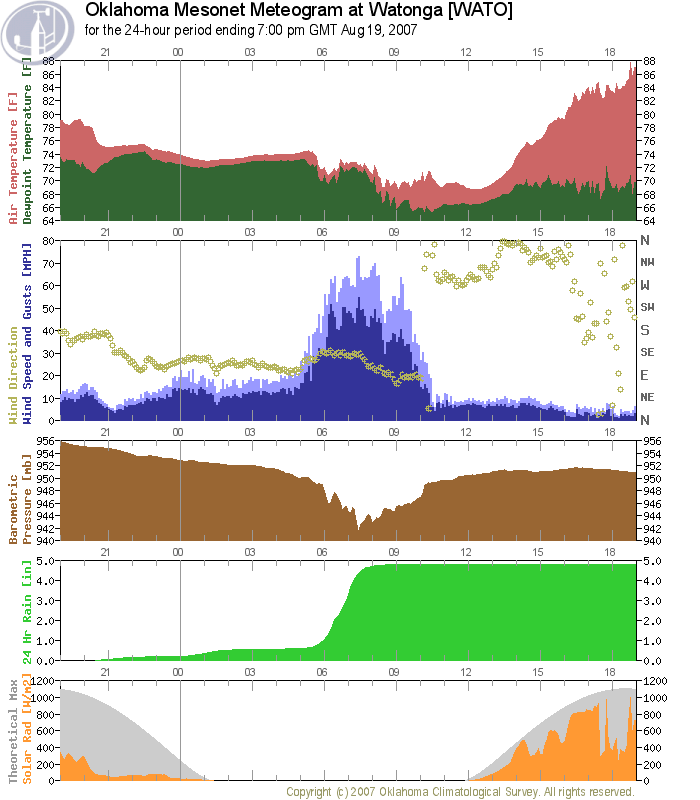
greater than tropical storm magnitude. The Watonga Mesonet station
measured the requisite 35-knot sustained winds for the better part
of three hours:
http://ticker.mesonet.org/archive/20070819/watonga.png
Notice the incredible pressure trace (brown) on this meteogram: as
the system wrapped up again, the pressure at Watonga bottomed out.
The rainfall is monumental, too: nearly four inches in 90 minutes.
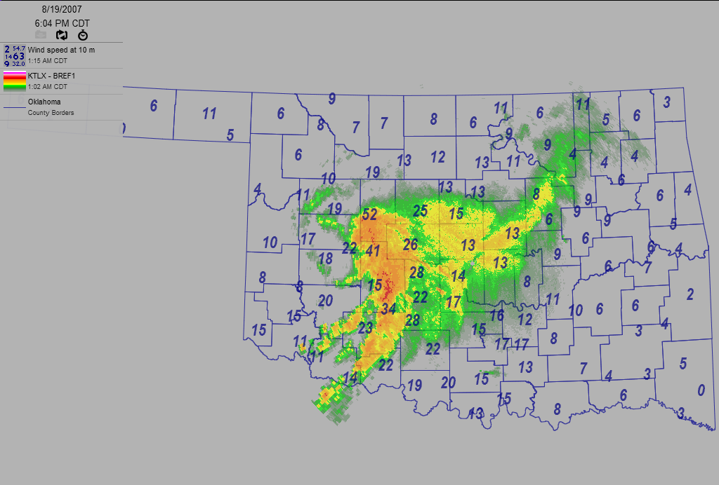
Sustained tropical storm winds weren't confined to Watonga. Several
stations in the region meaured adequate winds, including Hinton and
Fort Cobb. In the following image from about 6pm last night, Hinton
and Watonga show sustained winds of 41 and 52 mph, respectively.
http://ticker.mesonet.org/archive/20070819/1800.png
The center of circulation moved very slowly eastward over the next
12 hours, and the eye feature become MUCH better defined. Here's
an early-morning look:
http://ticker.mesonet.org/archive/20070819/0545.png
(the wind numbers on this map are gusts, but the wind barbs show a
symmetric well-balanced storm nearly 450 miles inland from its
landfall point.
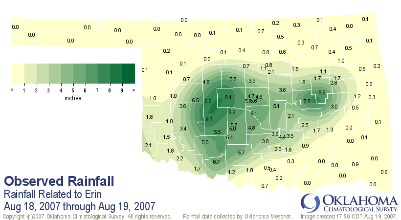
Finally, as with all tropical systems, rainfall was copious. The
numbers are still accumulating, but training echoes related to
Erin's rainfall bands dumped amounts approaching ten inches on parts
of the state:
http://ticker.mesonet.org/archive/20070819/erintot.png
Several volunteer observers also measured 10+ inch totals.
Thank you to the many Ticker readers who have sent information in the
last 12 hours. Your help and insight is greatly appreciated!
==================================================
The OCS/Mesonet Ticker
https://ticker.mesonet.org/
To subscribe or unsubscribe from the Ticker
or for questions about the Ticker or its content
Phone or Email the Ticker Manager at OCS
Phone: 405-325-2253 Email: ticker@mesonet.org
---------------------------------------------------
-C- Copyright 2024 Oklahoma Climatological Survey
===================================================
|


 Tweet
Tweet