Ticker for July 17, 2014
MESONET TICKER ... MESONET TICKER ... MESONET TICKER ... MESONET TICKER ...
July 17, 2014 July 17, 2014 July 17, 2014 July 17, 2014
Crying 'Fall'
Oh, we're going to get to this ridiculously cool weather in a minute. It shan't
escape my wrath, summer lover that I am. But let's get through the formalities
first and look at the new U.S. Drought Monitor map released this morning, which
is already obsolete. Remember, it only considers rainfall that fell through
Tuesday a.m., so what has fallen the last couple of days will have to wait until
next week's map.
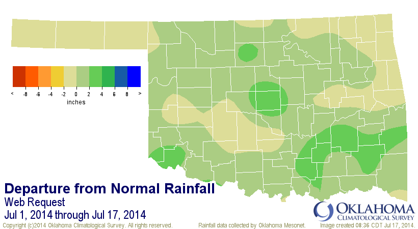
Here is the rainfall we considered, really going back a couple of weeks before
that.
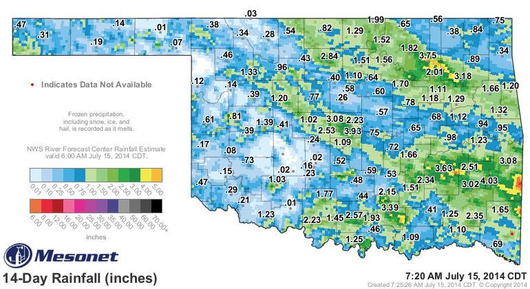
Resulting in this drought picture.
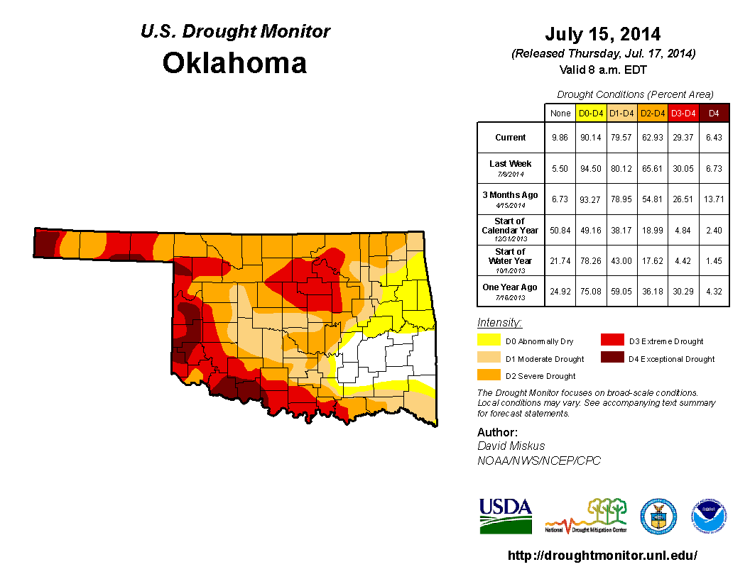
Where those 2-4 inch rains fell (central OK, far SE OK), we saw some improvement.
It wasn't a ton...most of the drought categories dropped by a percent or three.
But this is mostly immaterial due to what has happened SINCE Tuesday morning (and
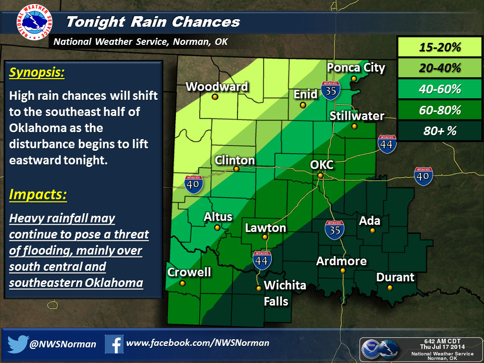
what will continue throughout the day). A look at the current radar map and the
48-hour rainfall map from the Mesonet shows us why.
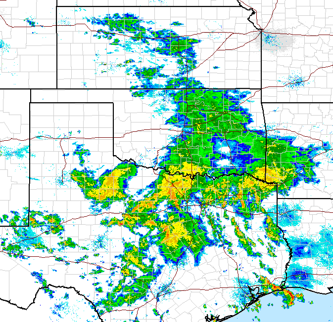
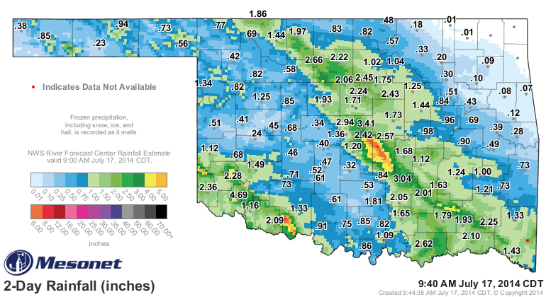
Some really nice totals across much of the SW two-thirds of the state, but 4.69
inches in Altus? Are you kidding me? Word from down that way that our friend
Lloyd Colston, Altus Emergency Manager, was seen running through the streets
asking for lumber to build an ark. Altus, which had been mired in D4 drought
for probably the longest period in the state, is in D2 this week, and probably
see a drop all the way down to D1 next week.
And Central OK saw a band of possible 4-8 inches from Spencer to just north of
Byars! Same for Cotton County down in the SW.
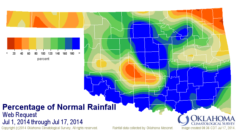
According to Mesonet rainfall numbers, our July 1-17 (through 8:35am, is already
the 24th wettest since at least 1921 with a statewide average of 2.12 inches,
0.62 inches above normal (about 141% of normal). The Panhandle is still
really dry, however, with an average of 1.07 inches, 0.37 inches BELOW normal
to rank as the 35th driest. This is their rainy season out that way, being tied
in somewhat with the Desert Southwest monsoon season.

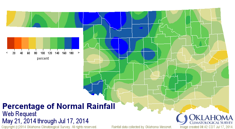
And I'll never let you forget this all really started back on May 21 after one
of the driest starts to the year on record. Spring did indeed return on May 21,
and it has yet to go away it seems like. At least the moisture part of spring.
Since May 21, we've seen a statewide average of 9.61 inches, 2.14 inches above
normal to rank as the 17th wettest May 21-July 17 since at least 1921. And
remember, it's still raining.


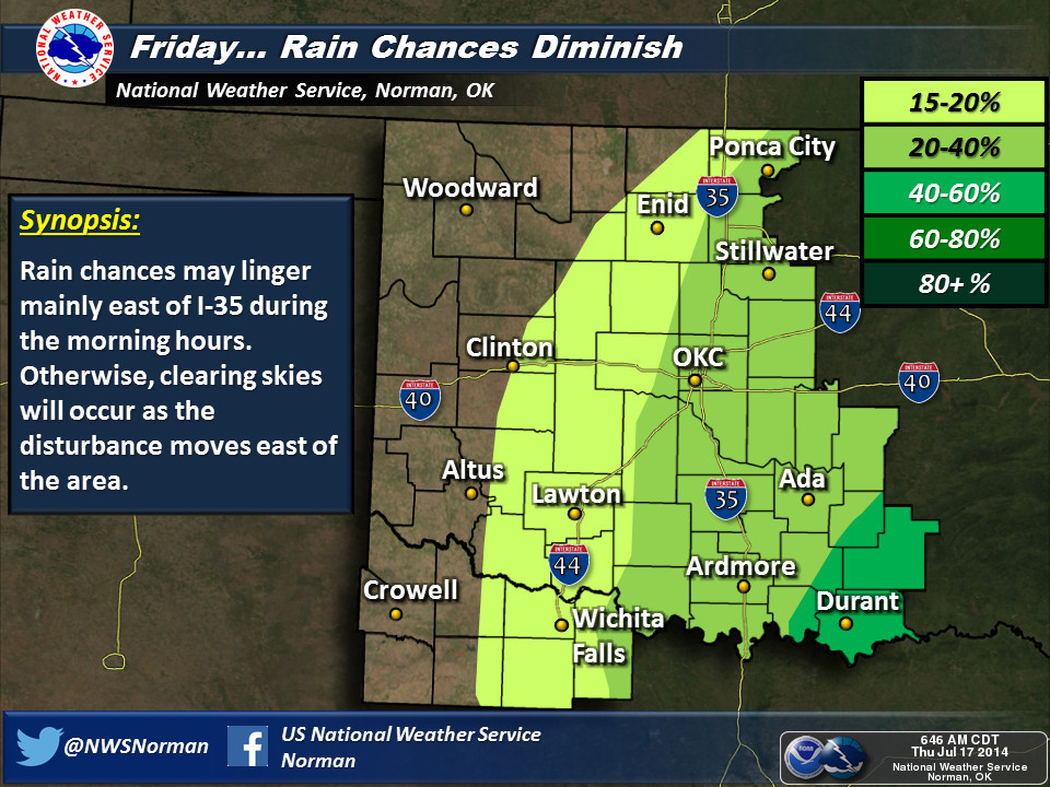
Rain chances will start to diminish from west to east as the day goes by, then
across the state tomorrow. Still lots of heavy rain possible across southern
and eastern Oklahoma.
-------------------------------------------------------------------------------
TEMPERATURES!
Okay, now on to temperatures. As expected, many places neared or broke records
yesterday for lowest maximum temperatures, and also this morning for lowest
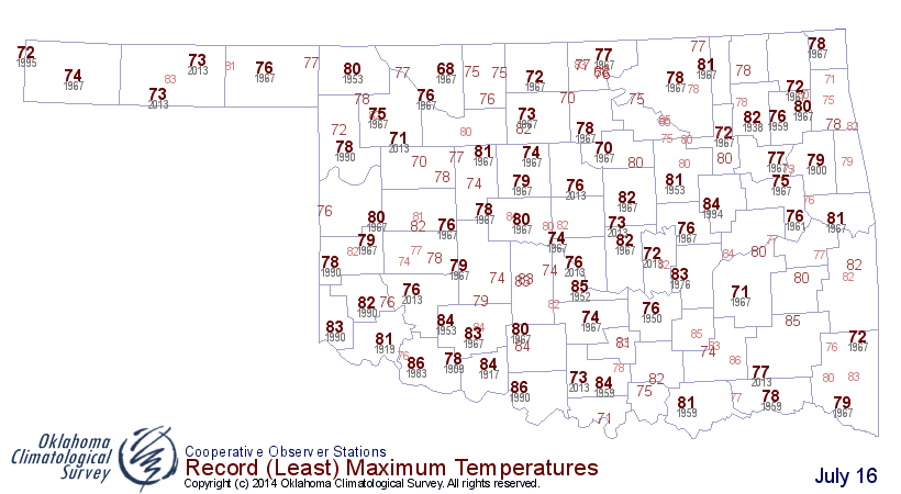
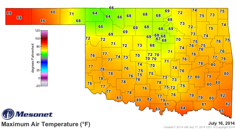
minimum temperatures. Here are the historical record low maximum temps for
yesterday, and the Mesonet high temps for yesterday as well.
(Obviously, somebody didn't get the news that it was October yesterday ...
<awkward silence as we try not to stare at the Panhandle>)
Lot's of those records obviously fell yesterday. For instance, Buffalo's lowest
high for July 16 prior to yesterday was 80 degrees, set back in 1953. Yesterday,
they reached 64 degrees. So they beat a 61 year old record by 16 degrees? Fairly
significant. Just check out this blurb from our friends across the hall at the
Norman NWS office:
"Did it seem cool today? The high temperature of 72 degrees at
Oklahoma City was the coolest July high temperature since 1996
and only the 6th time the high temperature has been this cool
in OKC in July since Oklahoma became a state. The high temperature
of 69 degrees at Ponca City is the coolest July high there since
1967. Records for coolest high temperature on July 16 were set at
Oklahoma City, Gage (69 degrees), and Lawton (81 degrees). With a
high of 84 today, Wichita Falls missed tying the record for the
date by one degree."
Then we have the low temperatures this morning, also "probably" breaking lots
of records.
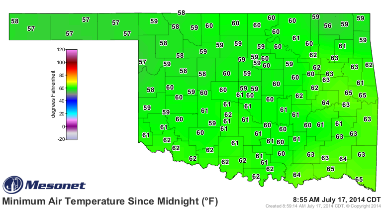
We know from our friends up the Turner Turnpike at the Tulsa NWS office that
McAlester broke their old record low of 61 (1990) this morning with a low of
58 degrees. McAlester and Muskogee also broke their record lows yesterday as
well.
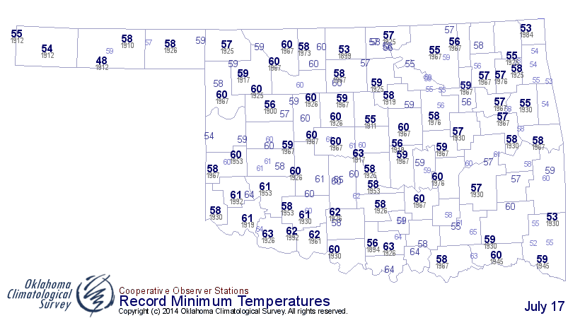
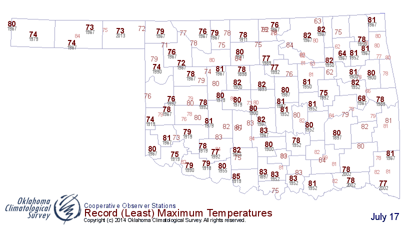
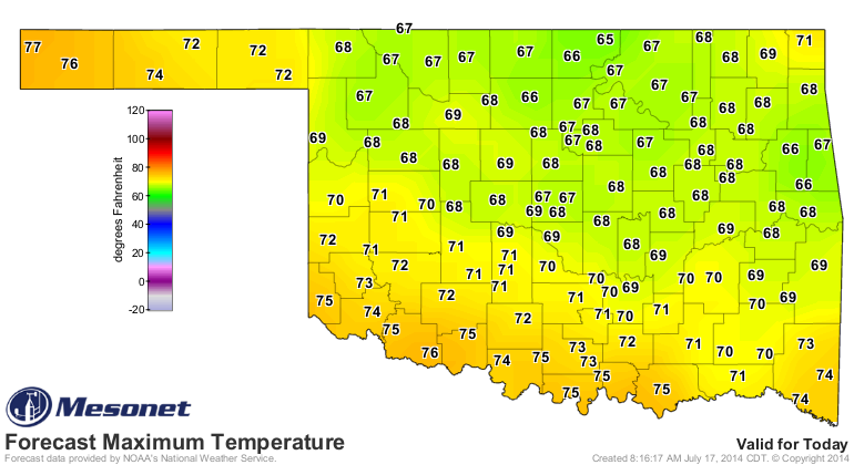
Now we look towards today's high temps to see how many records we can demolish.
Here are the forecast highs, and also the record low maximum temperatures,
historically, for July 17 (going all the way back to the 1880s, depending on
station).
Now for a little data mining. Yesterday's high temperatures of 64 degrees at
Buffalo and Freedom are SIGNIFICANTLY low. How significantly (-ly?)? Well,
the lowest maximum temperature ever recorded during July in the state was 59
degrees at Boise City back on July 25, 2004. Somewhere in Oklahoma has reached
a low maximum temperature of 60 degrees five times (again, dating back to the
1880s), four have only reached 61 degrees, a slew of stations have only reached
62, six stopped at 63 degrees for their daytime high, and another bunch have
only reached 64 degrees.
So in essence, Buffalo and Freedom tied with 11 other stations for the 32nd
lowest maximum temperatures ever recorded in the state during July. 32nd? Big
deal, right? Well, consider there are over 373,500 values behind them. Anybody
that can beat (or lower) 64 degrees gets to move on up the rankings.
Here are some more tidbits. Of those low maximum temperatures at or below 64
degrees, there were a few days that had most of them. The most notorious cool
July days, with the number of stations at or below 64 degrees, would be as
follows:
7/10/1895: 4 readings
7/12/1953: 5 readings
7/17/1967: 5 readings
7/10/1996: 7 readings
7/11/1996: 8 readings
So all the way back to 1895. The two days in 1996 must have been rainy and
chilly. Here is the Mesonet rainfall map from that two-day period.
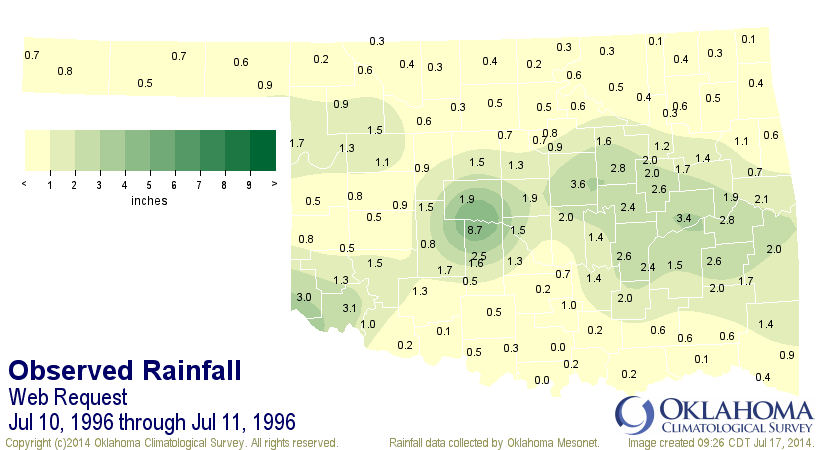
That was actually just a two-day microcosm of a very rainy period during a
very rainy July.
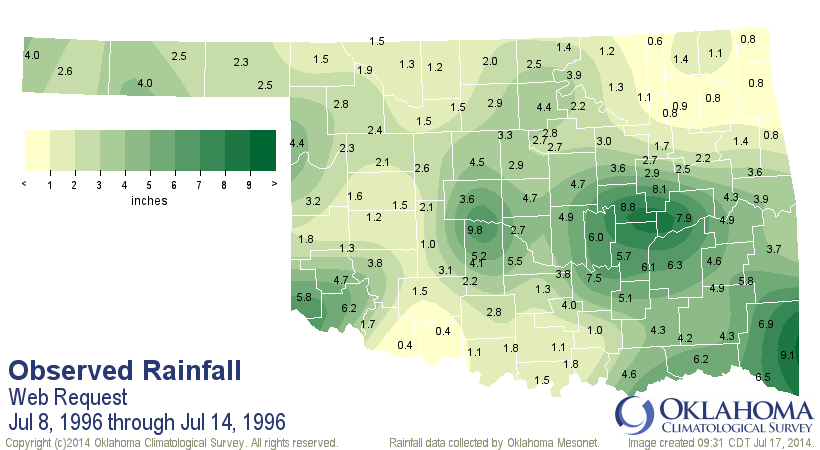
In fact, that was the fifth wettest July since statewide average records began
in 1895 at 5.93 inches. July 1950 had an astounding 9.07 inches on average
across the state.
Okay, I've bored you enough. Just one more little bite. The lowest temperature
ever recorded in Oklahoma during July?
41 degrees at Goodwell on July 5, 1915. The highest is 120 degrees, of course,
still the highest temp ever recorded in the state, and it happened at three
different stations:
Alva, July 18, 1936
Altus, July 19, 1936
Tishomingo, July 26, 1943
It was also matched at Poteau on August 10, 1936, and Altus again on August 12,
1936.
Done
(drops Excel spreadsheet, walks off stage)
Gary McManus
State Climatologist
Oklahoma Mesonet
Oklahoma Climatological Survey
(405) 325-2253
gmcmanus@mesonet.org
July 17 in Mesonet History
| Record | Value | Station | Year |
|---|---|---|---|
| Maximum Temperature | 111°F | HOLL | 2022 |
| Minimum Temperature | 54°F | KENT | 2009 |
| Maximum Rainfall | 6.42″ | BURB | 1997 |
Mesonet records begin in 1994.
Search by Date
If you're a bit off, don't worry, because just like horseshoes, “almost” counts on the Ticker website!