MESONET TICKER ... MESONET TICKER ... MESONET TICKER ... MESONET TICKER ...
July 1, 2022 July 1, 2022 July 1, 2022 July 1, 2022
Meltage
https://ticker.mesonet.org/archive/20220701/july-temp-outlook.png
The Ticker (and the Tocker) will be on vacation all next week...
(Pauses for applause...and yeah, I HEARD THAT!)
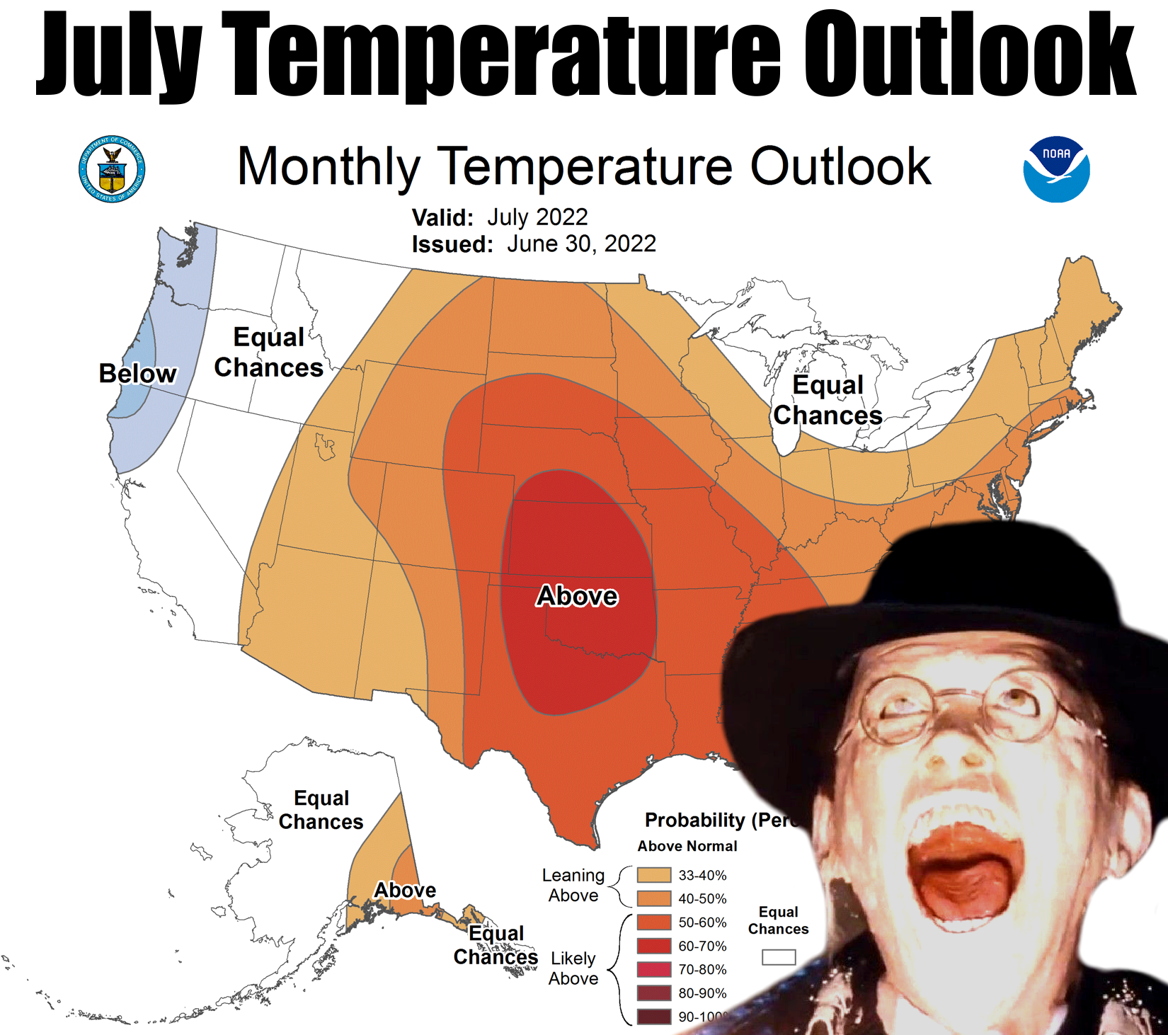
But there really isn't going to be a lot to talk about except lots of unrelenting
heat. Yeah, mace-felting...I mean face-melting heat! Expect highs to be 5-10
degrees above normal through the next week and beyond, which doesn't sound too
bad except any above normal temperature in July means HOT! Much the same as
a below normal temperature in January is going to be COLD!
See? Science! Don't try this at home, kids.
And if the actual air temperatures don't get ya, the heat index will.
https://ticker.mesonet.org/archive/20220701/july8-14-temp-hazards.png
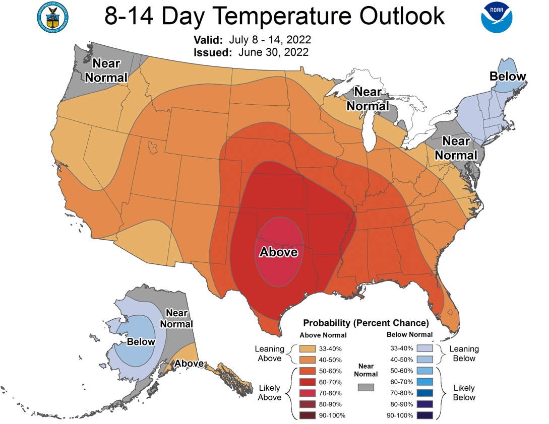
We know the next week is going to be hot, and it certainly appears that the
heat accelerates after that.
https://ticker.mesonet.org/archive/20220701/july8-14-temp-outlook.png
As for rain, lotsa luck! Actually, there will be some rain chances as that heat
dome meanders around. Under the death ridge itself, no dice, but if you manage
to get on the periphery (and we all know just how painful THAT can be), there
will be a chance for some moisture.
https://ticker.mesonet.org/archive/20220701/7day-rain-forecast.gif
Remember, rain (and the associated cloudiness) and soil moisture are the keys
to what type of summer you are having. It's shaping up to be a scorcher through
at least the next couple of weeks. Our only defense is fond memories of June's
cool periods whilst awaiting fall. In December.
So stick around and take a look back at June's weather when we were all young
and carefree. Cue the fanfare.
---------------------------------------------------------------------------------
June Teases Several Seasons
July 1, 2022
June managed to pack pieces of three seasons into a single month. The first 10
days were quite springlike, with abundant rainfall and high temperatures in the
70s and 80s. That there was very little in the way of severe weather was a
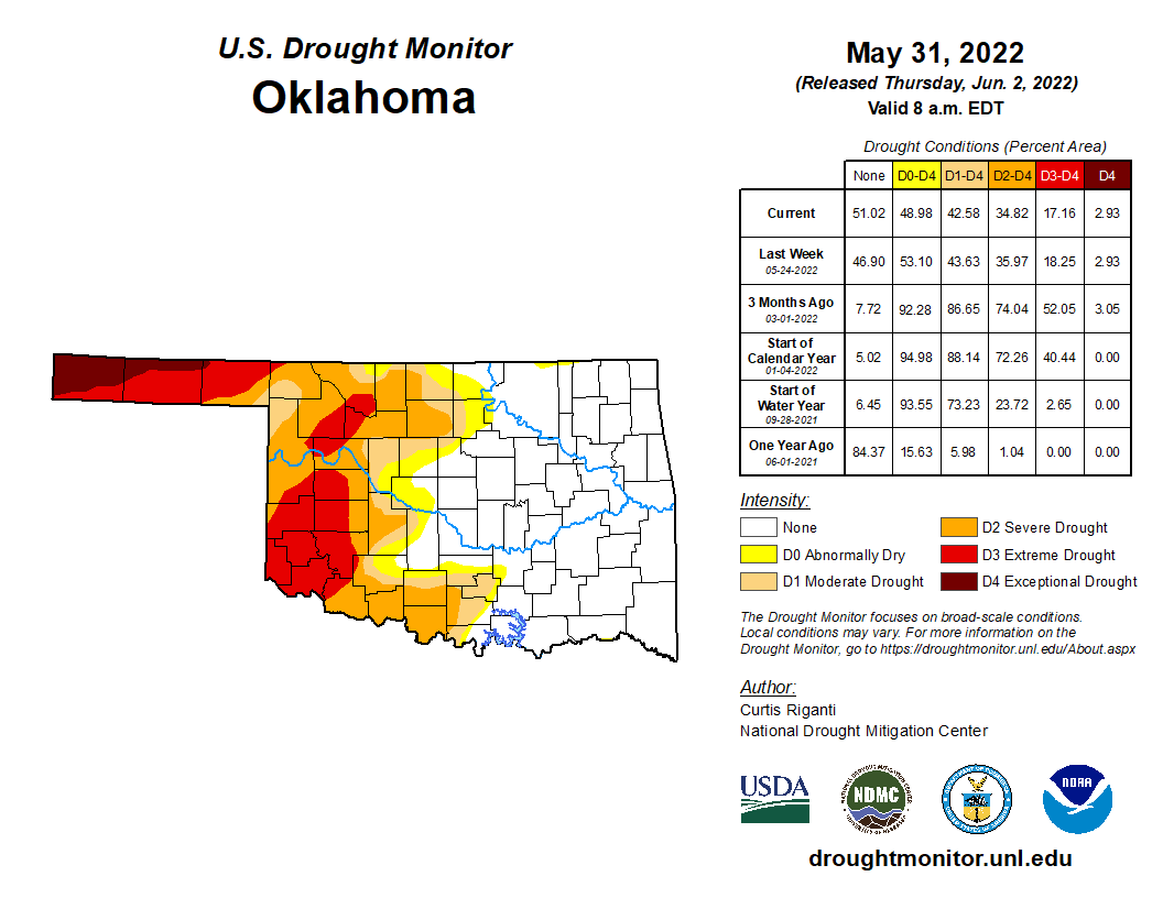
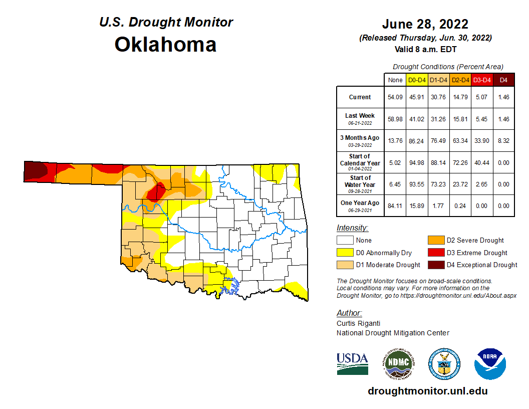
bonus for this period, as was the drought reduction across much of the state.
Drought coverage dropped from 43% of Oklahoma at the end of May to 31% at the
end of June according to the U.S. Drought Monitor, and the worst two categories
of drought—extreme and exceptional—fell from 17% to 5% over that same period.
A strong burst of sweltering summer weather dominated for the next couple of
weeks that saw relentless sunshine and high temperatures more befitting
mid-July than mid-June. High temperatures reached as high as 110 degrees during
the month’s middle stanza, and heat index values were as high as 120 degrees.
While the month ended with more summer heat, a strong cold front during that
last week dropped temperatures back down into the 70s and 80s for a few days—a
nice sneak preview of the fall weather to come in a few months’ time.
https://ticker.mesonet.org/archive/20220701/may31-drought.monitor.png
https://ticker.mesonet.org/archive/20220701/june28-drought.monitor.png
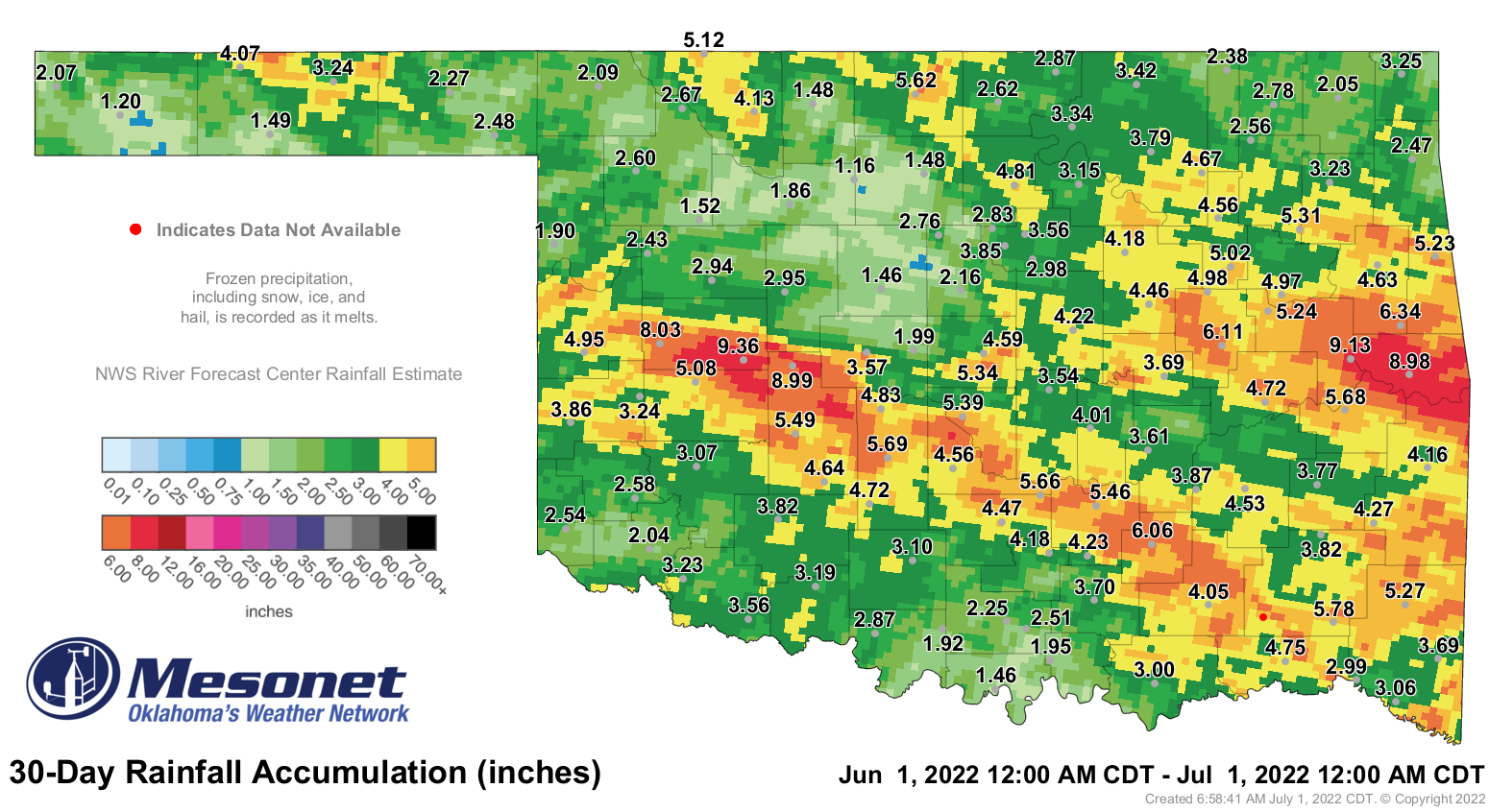
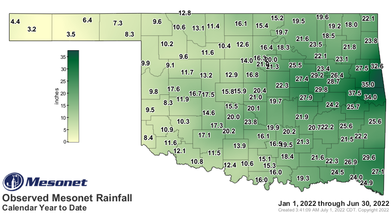
The statewide average rainfall total finished at 3.76 inches according to data
from the Oklahoma Mesonet, falling 0.5 inches below normal and ranking as the
63rd driest June since records began in 1895. Rainfall totals ranged from 9.36
inches at Weatherford—an unusual feat for a western Oklahoma site to have a
month’s highest rainfall—to 1.16 inches at Lahoma. Twenty-two of the Mesonet’s
120 sites collected at least 5 inches of rainfall for the month, although
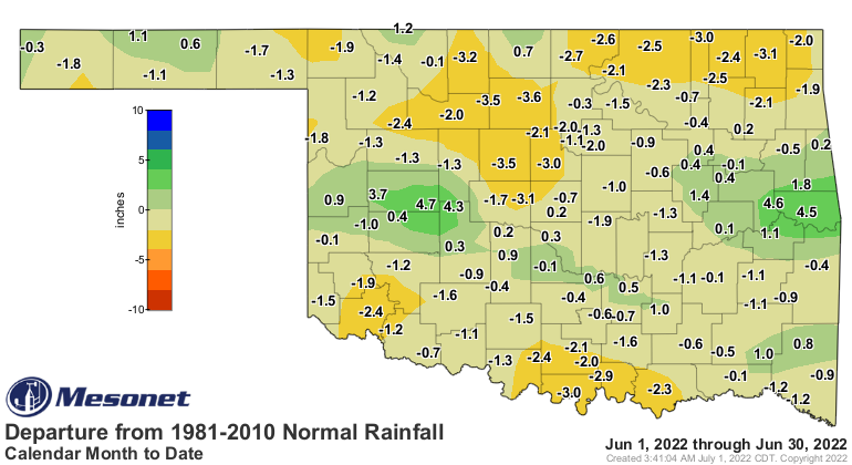
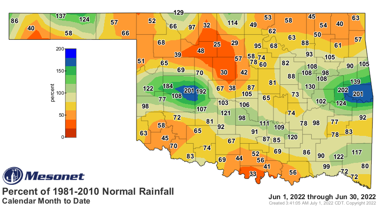
another 14 recorded under 2 inches. The heaviest totals ran in two strips
across the state from west to east: the first from west central through
southeast Oklahoma, and the second from central through east central Oklahoma.
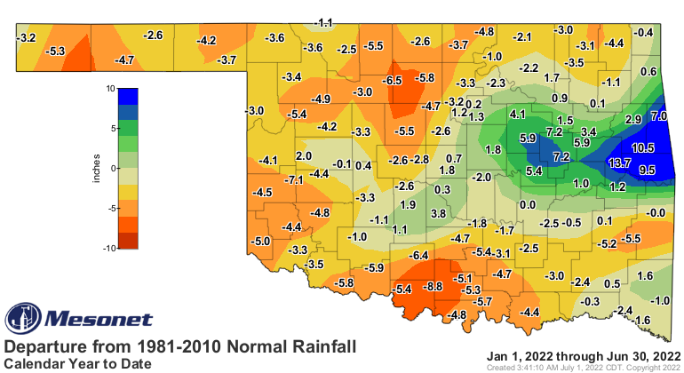
Surpluses ranged from 1-5 inches in these areas. Deficits of 2-3 inches
occurred in north central, northwestern, and south central Oklahoma. The
January through June period had a statewide average of 17.62 inches, 1.2 inches
below normal and ranked as the 68th driest first 6 months of the year on record.
https://ticker.mesonet.org/archive/20220701/june-rain-totals.png
https://ticker.mesonet.org/archive/20220701/june-rain-departure.png
https://ticker.mesonet.org/archive/20220701/june-rain-pct.png
https://ticker.mesonet.org/archive/20220701/jan-june-rain-totals.png
https://ticker.mesonet.org/archive/20220701/jan-june-rain-departure.png
https://ticker.mesonet.org/archive/20220701/jan-june-rain-pct.png
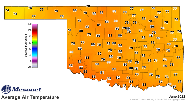
The statewide average temperature was 78.8 degrees, 1.5 degrees above normal
and ranked as the 30th warmest June on record. Heat dominated the month for
the most part, although significantly cool weather enveloped the state during
June’s first 10 days and also part of its final week. High temperatures in the
Panhandle failed to escape the 60s during the month’s first two days, but also
on the 26th and 27th. Low temperatures dropped to a chilly 48 degrees at the
Eva Mesonet site on June 28, the lowest reading of the month. The Mesonet
recorded triple-digit temperatures on 15 days during June. Altus soared to 110
degrees on June 12 for the month’s highest reading. That was also the highest
temperature recorded by the Mesonet in the state since Aug. 28, 2020, and the
highest June reading since 2013 when Freedom hit 111 degrees on the 27th of
that month. Based on statewide averages, June 12 was the hottest day in the
state since July 14, 2020, and the hottest June day since June 27, 2012. Heat
index values soared during the hottest part of the month. The Mesonet site at
Webbers Falls had the month’s highest heat index of 120 degrees on the 12th.
The highest heat index ever recorded on the Mesonet—dating back to 1997—was 125
degrees from Calvin on Aug. 9, 1999. The Mesonet observed heat index values of
at least 110 degrees 103 times during the month. The January-June statewide
temperature was 56.2 degrees, 0.1 degrees below normal and ranked as the 42nd
warmest such period on record.
https://ticker.mesonet.org/archive/20220701/june-avg-temps.png
https://ticker.mesonet.org/archive/20220701/june-avg-temps-depart.png
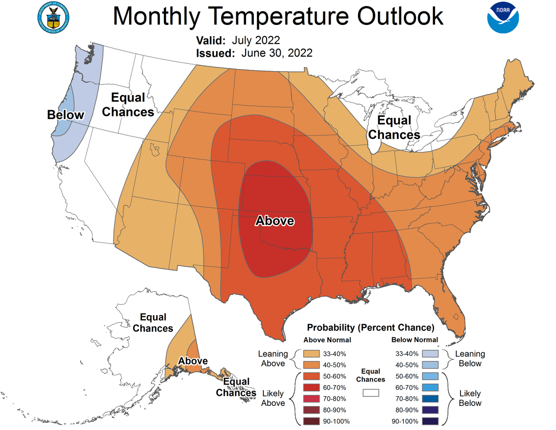
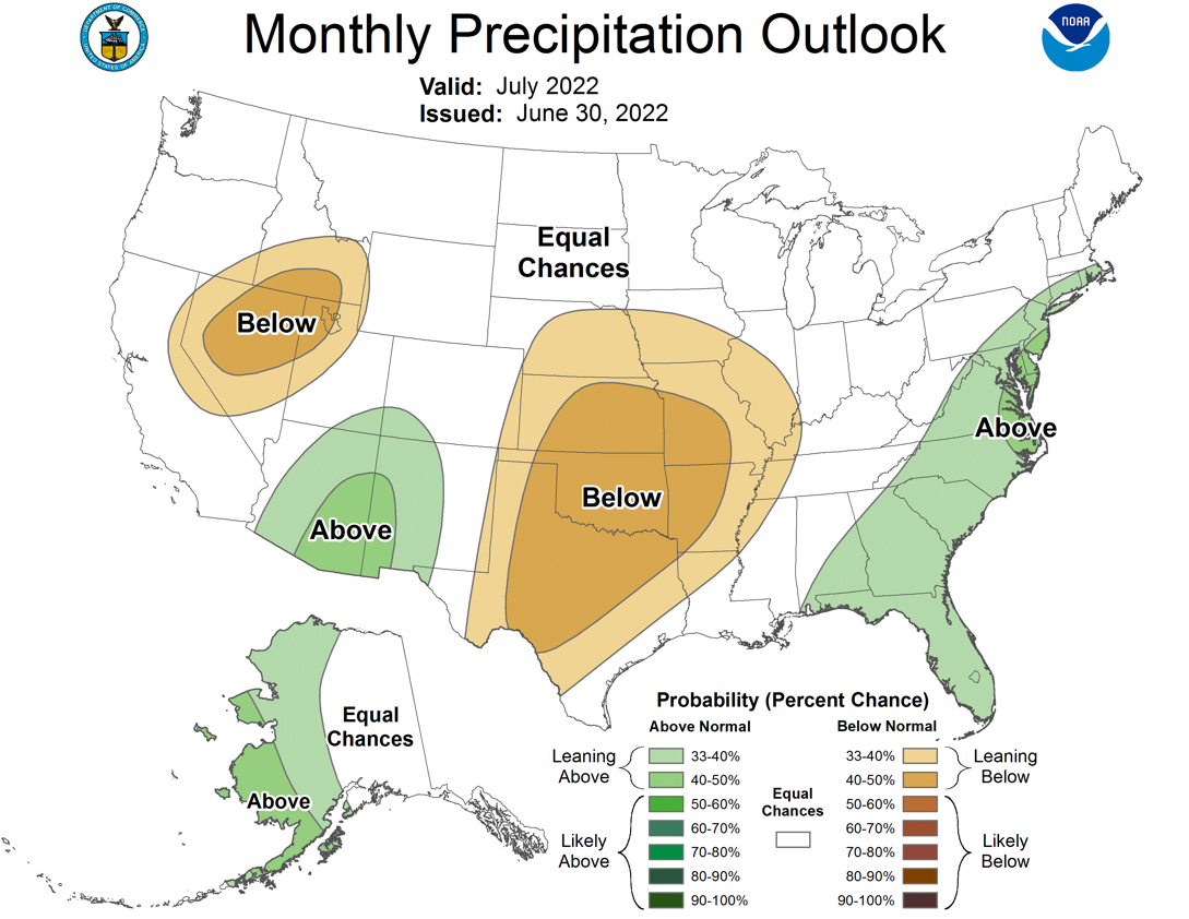
The hopes for a mild and wet July are a bit slim, at least according to the
outlooks from the Climate Prediction center. They show increased odds of above
normal temperatures and below normal precipitation. CPC’s July drought outlook
calls for drought to redevelop across western, southeastern, south central, and
northeastern sections of the state by the end of July. Rapid drought
development, or “flash drought,” is of particular concern if prolonged and
unusually hot and dry weather materializes.
https://ticker.mesonet.org/archive/20220701/july-temperature-outlook.png
https://ticker.mesonet.org/archive/20220701/july-precip-outlook.png
https://ticker.mesonet.org/archive/20220701/july-drought-outlook.png
###
Gary McManus
State Climatologist
Oklahoma Mesonet
Oklahoma Climatological Survey
gmcmanus@mesonet.org
==================================================
The OCS/Mesonet Ticker
https://ticker.mesonet.org/
To subscribe or unsubscribe from the Ticker
or for questions about the Ticker or its content
Phone or Email the Ticker Manager at OCS
Phone: 405-325-2253 Email: ticker@mesonet.org
---------------------------------------------------
-C- Copyright 2024 Oklahoma Climatological Survey
===================================================
|


 Tweet
Tweet