Ticker for June 23, 2014
MESONET TICKER ... MESONET TICKER ... MESONET TICKER ... MESONET TICKER ...
June 23, 2014 June 23, 2014 June 23, 2014 June 23, 2014
Memo to Mother Nature
Now we all know it's not nice to fool Mother Nature (you hear that Parkay??), but
if somebody could sneak in and change her clocks back about 12 hours, this
sleep-deprived climatologist would certainly appreciate it. Regardless, I hope
she knows that it is okay if it actually RAINS DURING THE DAYTIME!!
Screaming intended.
For the umpteenth time in the last month or so, we've had a complex of storms form
out in the High Plains and march to the southeast, bringing rain, high winds,
sometimes hail, and sometimes nature's worst alarm clock ... cloud-to-ground
lightning. The rain is appreciated (unless it floods), of course. Check out the
totals from last night's nocturnal event.
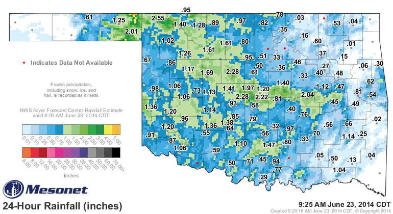
Not hard to see where last night's event got its start. Beaver County was the
lucky recipient of the trigger point, which also meant flash flooding with
lots of rain falling in a very short time. Some of those yellow areas on the
map indicate more than 4 inches! There was even a spotter report of a brief
tornado in an open field 10 miles WNW of Slapout. If that verifies, our tornado
count might jump to 8 for the year.
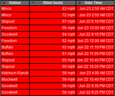
And then you can see the march to the southeast on the rainfall map. When that
squall line moved through, some areas received damaging winds. There were 14
wind gusts recorded by the Oklahoma Mesonet that exceeded severe limits (57
mph), including a window-rattling 83 mph gust at Minco last night at 2:30 a.m.
Yikes!
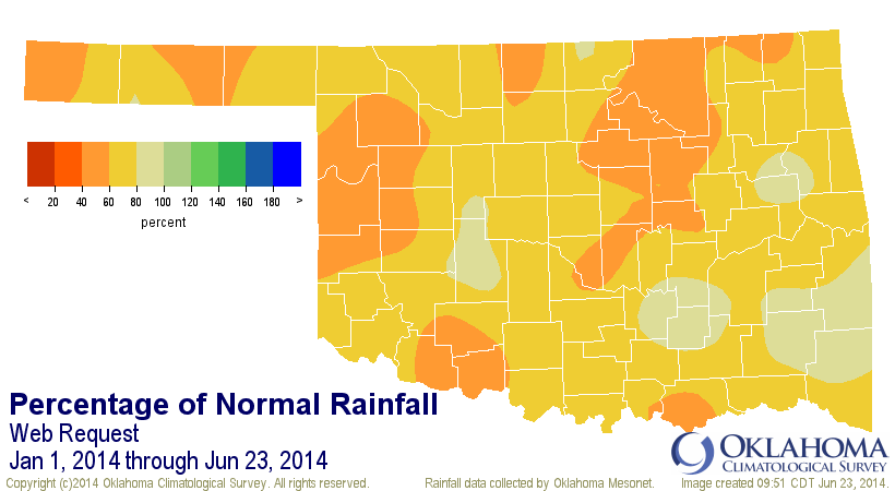
We also had lots of flooding across Oklahoma County. Again, referring to the
rainfall map, we see over 2 inches of rain fell in a short period of time. Now
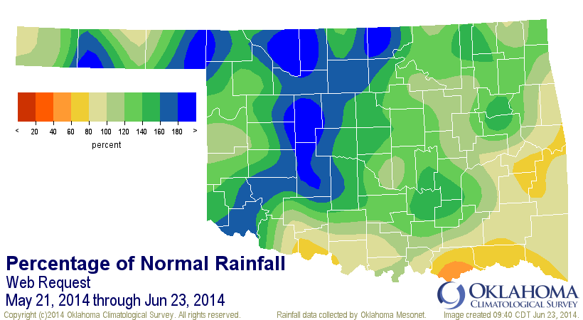
all this rainfall, which basically began in earnest on May 21, has really
started to add up. Check out the rainfall maps since that drought-denting
period began.


For the record (actually not a RECORD record, just a figure of speech), that is
the 18th wettest May 21-June 23 since at least 1921 with a statewide average of
6.65 inches, 1.65 inches above normal (133% of normal). For NC Oklahoma, which
had been the driest area of the state, it becomes the wettest, at least
by ranking with its 9th wettest such period on record (avg. of 7.64 inches,
3.01 inches above normal). I'm sure there are a few wheat growers up that way
that are a bit upset in the timing of the rain, but you take what you can get.
There are still dry areas of the state, however. You can see from the maps that
southern and especially SE Oklahoma are missing out on the good moisture. Seems
like we take one step forward in one area and two steps back in another. SE
OK is actually about an inch below normal for that period.
Still, we are dealing with long-term drought vs. short-term drought. We are
definitely starting to improve both, however. The year-to-date maps are
starting to look a bit better.
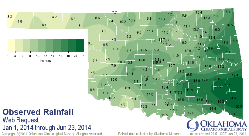

We are still about 5.6 inches below normal for the year thus far across the
state (average of about 12.21 inches has fallen), which makes it the 9th driest
such period since at least 1921.
Fortunes are changing, however. By May 22, OKC (Will Rogers Airport) had
recorded 3.94 inches of rain for the year up to that point, the 2nd driest on
record. Since that point, an additional 11.61 inches has fallen, bringing the
total for the year up to 15.55 inches. Normal through June 23 is 17.74 inches,
so OKC has nearly dug itself out of its 2014 moisture deficit. OKC might have
added a hundredth or two since earlier this morning as well.
Things look to quiet down just a bit now, and it is still raining across eastern
OK as we type. There will be a chance for showers and storms for the next few
days. Probably nothing as organized and widespread as last night. But the
longer we can prolong our wet season, the more mild our summer will be.
A few of these toad-stranglers during the daylight hours would be nice for a
change, however.
Gary McManus
State Climatologist
Oklahoma Mesonet
Oklahoma Climatological Survey
(405) 325-2253
gmcmanus@mesonet.org
June 23 in Mesonet History
| Record | Value | Station | Year |
|---|---|---|---|
| Maximum Temperature | 107°F | EVAX | 2021 |
| Minimum Temperature | 49°F | ANTL | 2001 |
| Maximum Rainfall | 5.64″ | TAHL | 2019 |
Mesonet records begin in 1994.
Search by Date
If you're a bit off, don't worry, because just like horseshoes, “almost” counts on the Ticker website!