MESONET TICKER ... MESONET TICKER ... MESONET TICKER ... MESONET TICKER ...
June 23, 2010 June 23, 2010 June 23, 2010 June 23, 2010
Altus, Meet Talihina
A rather odd feature on the temperature map that a Ticker victim...I mean
SUBSCRIBER, alerted me to a couple of days ago appeared once again yesterday.
Scan the 3:40 p.m. temperature map from yesterday then think like a
climatologist (80s fans, feel free to "Walk Like An Egyptian" while you're at
it).
http://ticker.mesonet.org/archive/20100623/current.TAIR.grad.png
The hot pocket of air over in LeFlore County in southeastern Oklahoma seems a
bit out of place. Normally you would expect to see something like that in the
drier air of the southwest. In this case, we can consider LeFlore County an
honorary member of the southwestern Oklahoma semi-arid community, as
demonstrated by the following maps. First off is the dewpoint map:
http://ticker.mesonet.org/archive/20100623/current.TDEW.grad.png
Then take a look at the soil moisture at 25 cm:
http://ticker.mesonet.org/archive/20100623/mesonet.daily.current.FW25.grad.png
So it is indeed a bit drier in that part of the state, and that stems from their
short- and long-term rainfall deficits. The following two maps indicate LeFlore
County has received less than 20 percent of normal rainfall in the last 30
days:
http://ticker.mesonet.org/archive/20100623/last30dayspct.png
and 40-60 percent of normal rainfall in the last 90 days:
http://ticker.mesonet.org/archive/20100623/last90dayspct.png
Okay, NOW take a look at the air temp, soil moisture and percent of normal
rainfall map together and the patterns become a bit more clear:
http://ticker.mesonet.org/archive/20100623/dry_begets_hot.png
So the drier atmosphere and soil allow more of the sun's energy to go towards
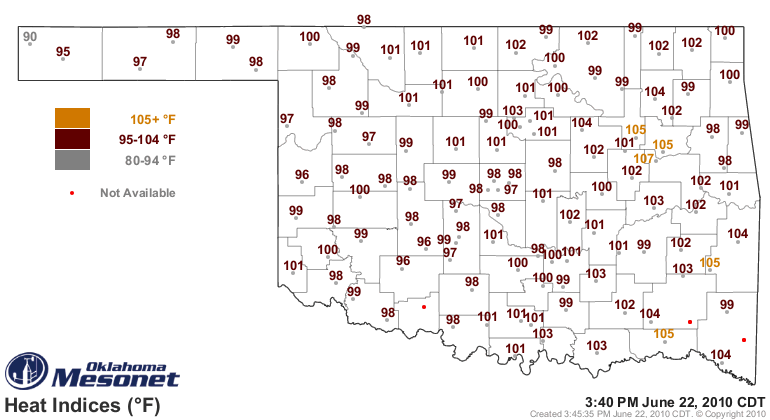
heating the surface. However, there was still enough humidity to give LeFlore
County some really hefty heat index values:
http://ticker.mesonet.org/archive/20100623/current.heat.gif
Now LeFlore County is no stranger to high temperatures. Just ask the town of
Poteau, which managed to tie the state record high temperature with a 120-degree
reading on August 10, 1936:
http://ticker.mesonet.org/archive/20100623/august10_1936.png
No doubt a lovely day in LeFlore County.
Another reader asks about the all-time high dewpoints and minimum temperatures
measured by the Mesonet. So for your perusal, here are the top-10 highest
Mesonet dewpoints and highest minimum temperatures.
Top-10 Highest Mesonet Dewpoints (degrees F)
Broken Bow 7/28/1995 87.4
Bixby 6/19/1996 87.1
Bowlegs 7/09/1995 86.8
McAlester 7/17/1994 86.8
Cloudy 7/28/1995 86.8
Broken Bow 7/03/1996 86.3
Cookson 7/28/1995 86.1
Butler 8/01/1996 85.9
Wilburton 7/16/1994 85.8
Antlers 7/28/1995 85.8
Top-10 Highest Mesonet Minimum Temperatures (degrees F)
Fairview 7/21/2003 86.4
Ada 7/07/1996 85.8
Fairview 7/06/1996 84.9
Durant 7/07/1996 84.7
Fairview 7/20/2006 84.7
Guthrie 7/26/1998 84.5
Fairview 9/03/2000 84.5
Guthrie 7/14/2009 84.4
Kingfisher 7/21/2003 84.4
Guthrie 8/25/2006 84.2
Not surprisingly, the highest dewpoints (save for Butler, which is in Custer
County in the west) occurred in eastern Oklahoma. Fairview and Guthrie seem
to dominate the warm minimum temperature category with seven of the top 10.
Interesting. It would seem reasonable to think Guthrie's high minimums could
be heat pollution from the OKC metropolitan area. Fairview is a bit of a
conundrum, however. Maybe their meteogram will yield some clues.
http://ticker.mesonet.org/archive/20100623/fairview_meteogram_july21-2003.png
Theories? It appears that strong southerly winds kicked up right before midnight
and the temperature began to rise.
The game is afoot.
Gary McManus
Associate State Climatologist
Oklahoma Climatological Survey
(405) 325-2253
gmcmanus@mesonet.org
==================================================
The OCS/Mesonet Ticker
https://ticker.mesonet.org/
To subscribe or unsubscribe from the Ticker
or for questions about the Ticker or its content
Phone or Email the Ticker Manager at OCS
Phone: 405-325-2253 Email: ticker@mesonet.org
---------------------------------------------------
-C- Copyright 2024 Oklahoma Climatological Survey
===================================================
|


 Tweet
Tweet