Ticker for June 11, 2010
MESONET TICKER ... MESONET TICKER ... MESONET TICKER ... MESONET TICKER ...
June 11, 2010 June 11, 2010 June 11, 2010 June 11, 2010
Heat Burst-amundo!
Even the Fonz wouldn't have been cool last night in northwestern Oklahoma when
dying thunderstorms produced one of the coolest - errrrrrr ... hottest - hazards
around: the heat burst. Yes, I referenced the Fonz. Sit on it! The Ticker has
talked about heat bursts many times in the past, but they're still cool to take
a look at. And they do have an effect well past their deaths. For instance, take
a look at the Mesonet temperatures at 7:05 AM this morning:
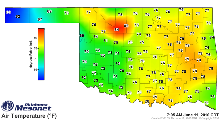
Can you tell where the heat burst was? It's pretty obvious a heat burst affected
Harper County down through Major County. And if you're out working in the early
morning - wheat harvest perhaps - it would give you a chance to start cutting
wheat earlier with all that drying that went on overnight. However, a
construction job or even soccer practice would not be quite as pleasant. Check
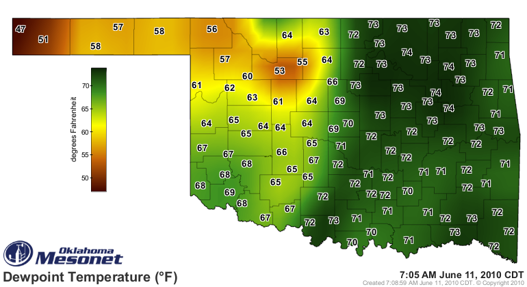
out the Mesonet dewpoint temperatures from 7:05 AM:
The heat bursts brought winds of up to 60 mph to Camargo, Freedom and Woodward
after midnight:
Station Wind Gusts Time
Camargo 60 mph 3:05 am
Camargo 59 mph 3:10 am
Camargo 59 mph 12:10 am
Seiling 58 mph 3:30 am
Camargo 58 mph 2:50 am
Camargo 58 mph 2:35 am
Camargo 57 mph 3:35 am
Camargo 57 mph 3:25 am
Camargo 57 mph 2:40 am
Camargo 57 mph 2:25 am
Camargo 56 mph 3:20 am
Freedom 56 mph 2:45 am
Woodward 56 mph 12:10 am
Camargo 55 mph 3:45 am
Camargo 55 mph 2:55 am
Freedom 55 mph 2:50 am
Camargo 55 mph 2:20 am
The event can be followed in this quicktime movie from WeatherScope showing
the Vance AFB radar, the air temperature (colored gradient) and wind speeds
(white wind flags). You'll notice the event starts in Harper County and ends up
centered over Fairview. This file is a bit large (~10 Mb) so you may want to
download it before playing:
https://content.mesonet.org/ticker/archive/20100611/heatbursts.mov
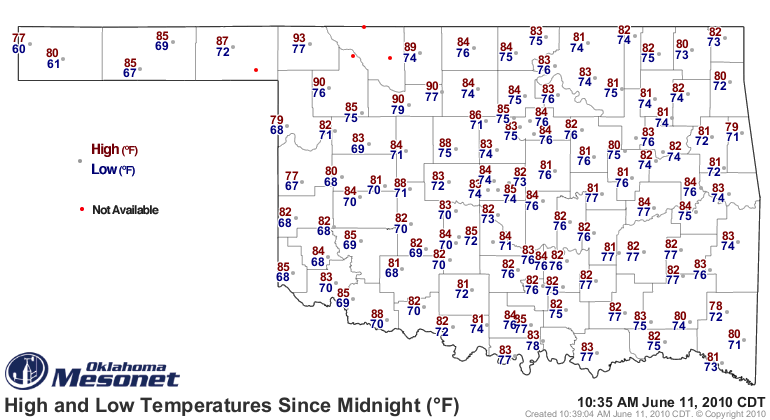
It certainly made a difference in the high-low temperature map since midnight.
Notice that some of the high temperatures in the northwest are in the 90s
already. Those were actually set overnight with the heat bursts. And the low
temperature at Fairview only made it to 79 degrees despite the dry air while
the mid-70s to the east were due to the moist air in place.
And of course, you can see the event in our stations' meteograms, like this one
at Cherokee:
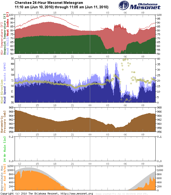
Notice the sharp dewpoint drop and increases in wind speed and temperature.
Very cool!
Gary McManus
Associate State Climatologist
Oklahoma Climatological Survey
gmcmanus@mesonet.org
(405) 325-2253
June 11 in Mesonet History
| Record | Value | Station | Year |
|---|---|---|---|
| Maximum Temperature | 108°F | ALTU | 2022 |
| Minimum Temperature | 44°F | KENT | 2004 |
| Maximum Rainfall | 6.05″ | COPA | 2007 |
Mesonet records begin in 1994.
Search by Date
If you're a bit off, don't worry, because just like horseshoes, “almost” counts on the Ticker website!