MESONET TICKER ... MESONET TICKER ... MESONET TICKER ... MESONET TICKER ...
June 8, 2023 June 8, 2023 June 8, 2023 June 8, 2023
All others must bow!
https://ticker.mesonet.org/archive/20230608/el-nino-advisory.png
To quote that dude that used to handle roses on TV, and also work on Channel 9 as
a sports anchor..."It's official." No wait, that was the guy that used to keep
people captive on an island on that other reality show.
Well, it doesn't matter. What DOES matter is that the Climate Prediction Center
has issued an "El Nino Advisory," which means:
"Issued when El Ni˝o conditions are observed and expected to continue."
And to quote NWS Southern Region meteorologist Victor Murphy:
"The screaming message is that the atmospheric reaction has now coupled with the
warm temps in the Nino 3.4 Region of the Equatorial Pacific Ocean. This was the
last domino to fall, as the Nino 3.4 SSTAs weekly average was +0.8C. As a result,
CPC has issued an El Nino Advisory!"
In other words, the Sea Surface Temps (SST) have been in El Nino territory of
+0.5C for awhile, but the necessary coupling with the atmosphere has now occurred
and a full-fledged El Nino is here.
Here's a look at all the things that have to occur to get an official El Nino
declaration.
https://ticker.mesonet.org/archive/20230608/DiagnosticFlowchart_610.png
Here's a bit more info from CPC:
"At this time, the range of possibilities at the peak of the event
(November-January) include an 84% chance of at least a moderate El Ni˝o (> 1.0C)
to a 56% chance of a strong El Ni˝o (> 1.5C). There is a 25% chance of an event
greater than 2.0C."
You can see those probabilities on this here table showing the chances for each
SST anomaly as we go forward into the 3-month periods (starting with MJJ, or
May-June-July, and ending with JFM, or January-February-March of 2024). I've
labeled the weak, moderate, strong categories for your ENSO-determining pleasure.
https://ticker.mesonet.org/archive/20230608/ENSO-magnitude-probability.png
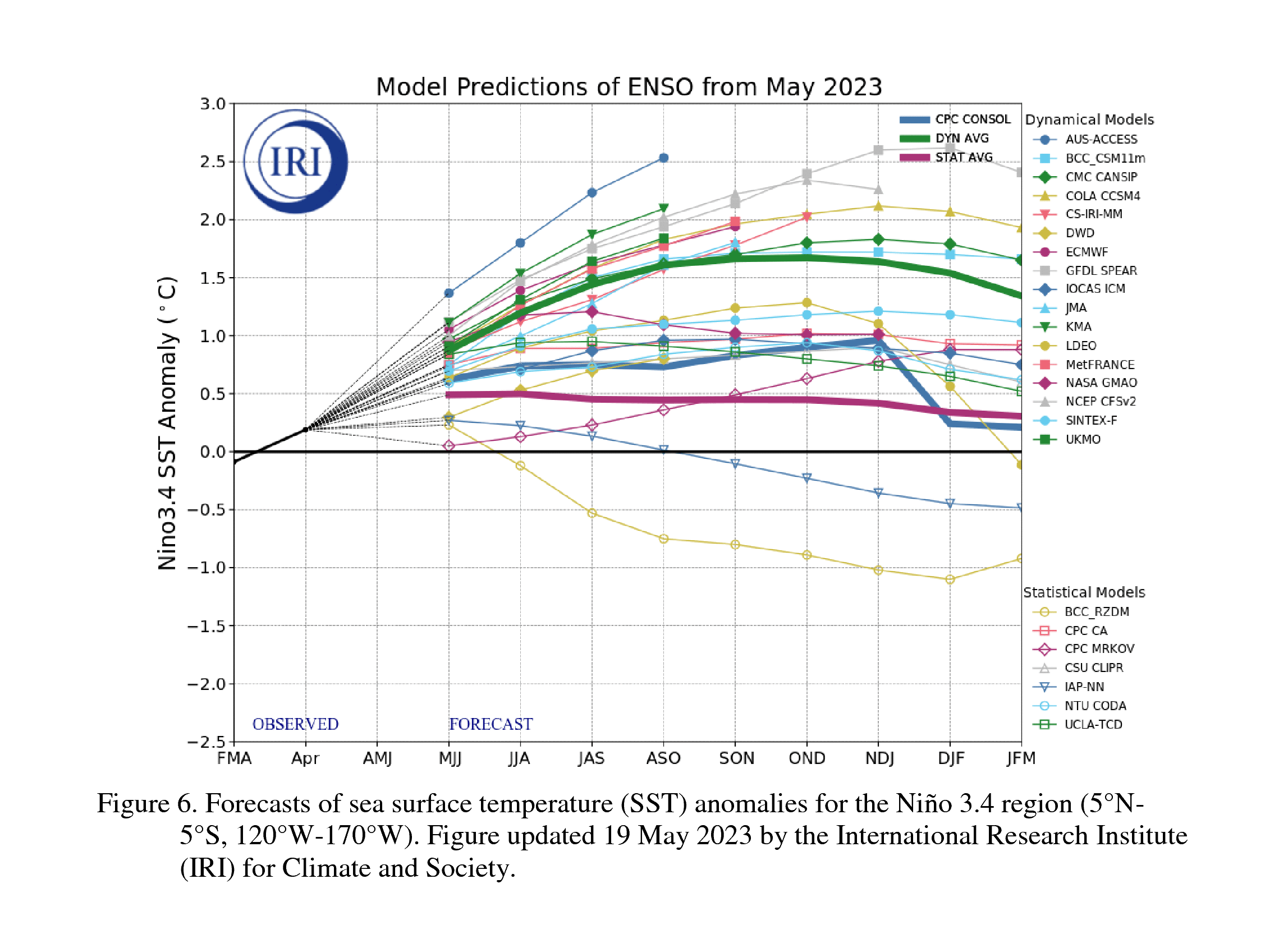
And you can see here the actual modeled predictions through that same period.
https://ticker.mesonet.org/archive/20230608/enso-predictions.gif
Now as we all know by now, El Nino becomes important in our neck of the woods
come the cool season when we get into the cool season, mid-Fall'is through
mid-Spring'ish (so let's say November through March...ish). Impacts peak in
winter.
https://ticker.mesonet.org/archive/20230608/ElNino-Jet-Wintertime-Pattern.jpg
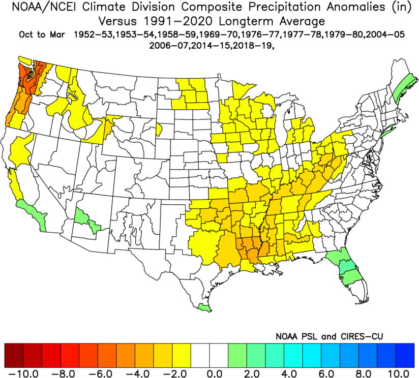
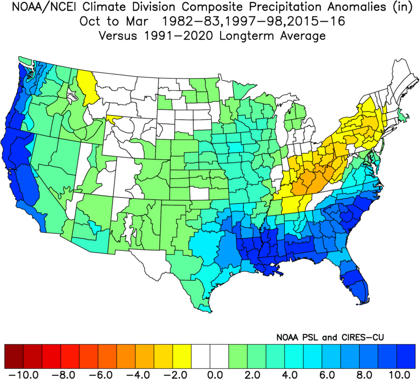
It doesn't always work out this way, of course. Each El Nino and its impacts
are different, but strength does tend to matter as you can see from these
precip anomaly maps for each category of weak, moderate, strong, and very-strong
El Nino events since 1950.
https://ticker.mesonet.org/archive/20230608/el_nino_wk.png
https://ticker.mesonet.org/archive/20230608/el_nino_mod.png
https://ticker.mesonet.org/archive/20230608/el_nino_stg.png
https://ticker.mesonet.org/archive/20230608/el_nino_vstg.png
And let's remember that there is still a small chance El Nino DOESN'T continue
into the fall, but fades away. As Emily Becker, ENSO Guide-Extraordinaire states
in her blog:
"...nature always has surprises in store, and predicting anything several
months in advance is difficult. While El Ni˝o conditions have developed,
thereĺs still a small chance (4-7%) that things will fizzle out. Clearly, we
think this is unlikely, but itĺs not impossible. The incredible warmth of the
global oceans could throw us a curveball, since weĺve not seen this before.
Another potential, but also less likely, outcome is a weak El Ni˝o, with about
a 12% chance."
Oh, so YOU'RE TELLING ME THERE'S A CHANCE!
Yes, very small though. You can read more of Emily's fantastic blog about the
current El Nino here:
https://www.climate.gov/news-features/blogs/june-2023-enso-update-el-ni%C3%B1o-here
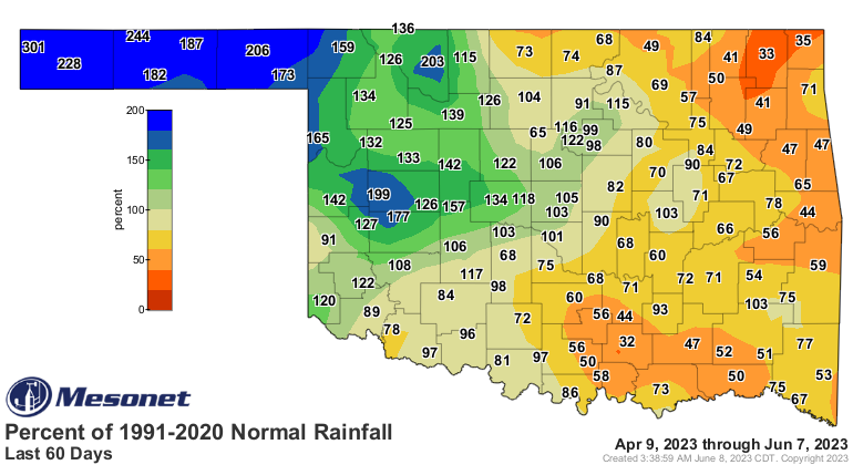
Now I know that folks are gonna want to tie in our recent rains with this El
Nino, but I don't think so. The atmosphere has just become coupled with the SST
anomalies, so before then I think we can just chalk our rains up to that
persistent ridge of high pressure to our east pumping Gulf Moisture up and over
us into upslope flow across the High Plains. Add in storm systems coming across
and you get our last 30-60 days of rainfall.
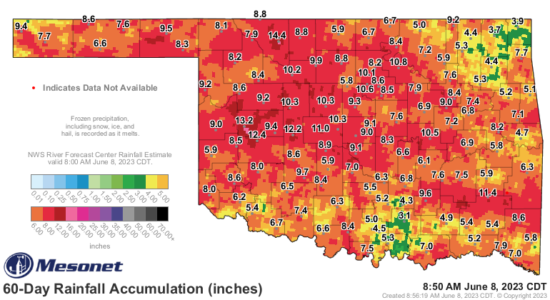
https://ticker.mesonet.org/archive/20230608/30day-rain-toals.png
https://ticker.mesonet.org/archive/20230608/pct30day_rain.current.png
https://ticker.mesonet.org/archive/20230608/60day-rain-totals.png
https://ticker.mesonet.org/archive/20230608/pct60day_rain.current.png
The eastern half of Oklahoma, having been more under the influence of that ridge,
is not impressed. Keep in mind that the jet stream has been quite weak over us
as well over the last 30 days or so, which is also why we haven't had a lot of
severe weather. And a strengthened jet stream is one of the impacts expected
during an El Nino event. I could be wrong on that diagnosis, of course. Smarter
people (which includes a broad range of the U.S. population) than me might have a
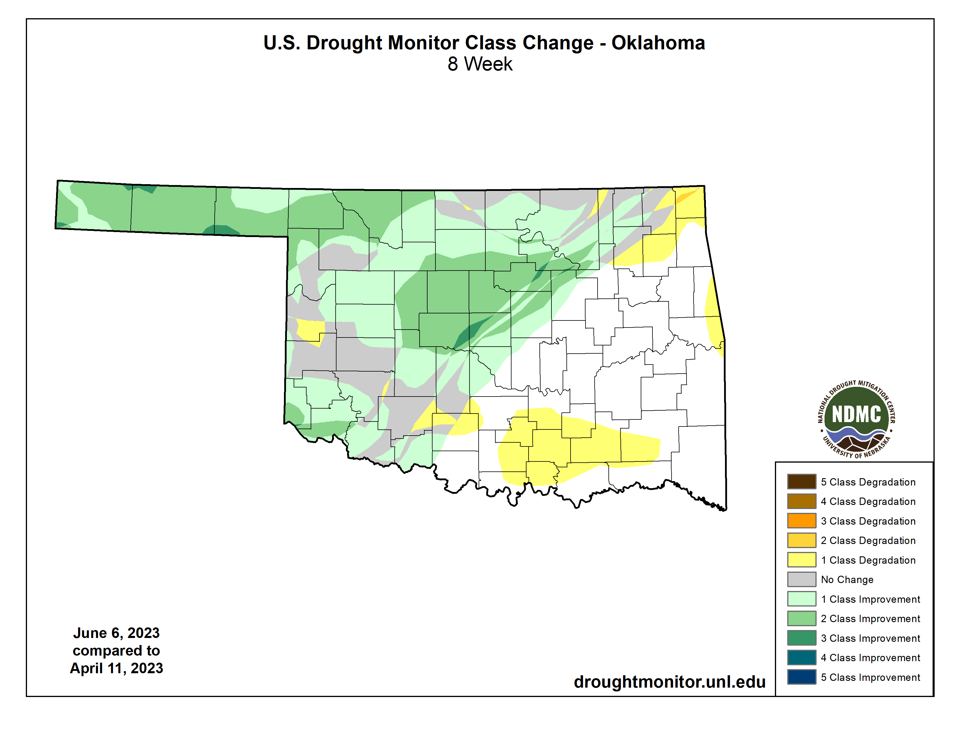
different take. NOT a different take to be had here...the drought has been
significantly impacted by our rains of the last 30-60 days.
https://ticker.mesonet.org/archive/20230608/20230606_ok_trd.png
https://ticker.mesonet.org/archive/20230608/2month-DM-change.png
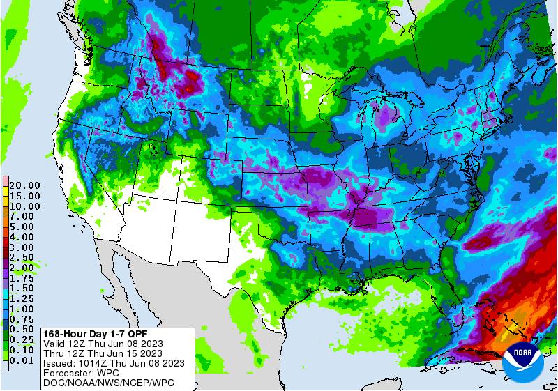
Looking ahead, our tropical-like western OK rainfall bounty might be coming to
an end.
https://ticker.mesonet.org/archive/20230608/7day-rain-forecast.gif
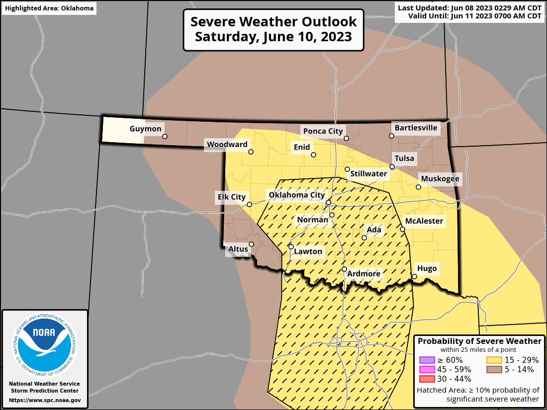
Hopefully this pans out for eastern OK at least. They definitely need the rains
to come back in that area. Speaking of severe weather (weren't we??), there
will be a chance of some severe winds and big hail on Saturday.
https://ticker.mesonet.org/archive/20230608/OK_swody3_PROB.png
Looks rather ominous, but tornadoes don't appear to be a big threat.
Gary McManus
State Climatologist
Oklahoma Mesonet
Oklahoma Climatological Survey
gmcmanus@mesonet.org
==================================================
The OCS/Mesonet Ticker
https://ticker.mesonet.org/
To subscribe or unsubscribe from the Ticker
or for questions about the Ticker or its content
Phone or Email the Ticker Manager at OCS
Phone: 405-325-2253 Email: ticker@mesonet.org
---------------------------------------------------
-C- Copyright 2024 Oklahoma Climatological Survey
===================================================
|


 Tweet
Tweet