MESONET TICKER ... MESONET TICKER ... MESONET TICKER ... MESONET TICKER ...
June 2, 2011 June 2, 2011 June 2, 2011 June 2, 2011
Two streaks enter, no streaks leave!
Master Blaster might run Bartertown, but Mother Nature holds sway over Oklahoma.
Yesterday, she ended two streaks ... one good and one bad. Now in reality the
good streak ended on May 24th when a long-track violent tornado traveled from
near Binger to Guthrie. Based on wind speed measurements of over 210 mph from a
University of Oklahoma mobile doppler radar and additional damage surveys, the
NWS office in Norman made the determination yesterday that the tornado reached
EF-5 levels as it crossed Interstate 40 near El Reno. The tornado killed 9
people on its 75-mile path, including 5 people on or near Interstate 40. It
also demolished an active oil rig just north of the highway near the Calumet
junction. You can see pictures of that rig here:
http://www.drillingahead.com/page/cactus-rig-117-tornado-damage
The streak of years without an EF-5 in Oklahoma ends at 11. The last tornado of
that strength in Oklahoma was the May 3, 1999 monster that went through Bridge
Creek, Moore and Oklahoma City, killing 36.
http://www.srh.noaa.gov/images/oun/wxevents/19990503/maps/bigoutbreak.gif
Believe it or not, that's only the 13th EF-5 (or F5 ... the Fujita Scale was
replaced operationally by the Enhanced Fujita Scale in 2007) tornado to occur
in Oklahoma since 1905. Those big baddies are exceedingly rare (about 2% of all
tornadoes), but they account for about 70% of tornado deaths.
Oklahoma F5 Tornadoes (courtesy of NWS Norman):
1) May 24, 2011 Binger-El Reno-Piedmont-Guthrie
2) May 3, 1999 Amber-Bridge Creek-Moore-OKC-Midwest City-Del City
3) April 2, 1982 Hugo-Broken Bow-Valiant
4) March 26, 1976 Spiro
5) May 5, 1960 Shawnee-Prague-Sapulpa
6) May 25, 1955 Udall, KS (Tornado began in OK)
7) May 25, 1955 Blackewll
8) April 9, 1947 Woodward
9) April 12, 1945 Antlers
10) April 19, 1939 Vici-Alva-Capron
11) April 27, 1912 Hobart-Colony
12) April 12, 1912 Hennessey
13) May 10, 1905 Snyder
The 2011 tornado count for Oklahoma is now up to at least 77 according to
preliminary data from the National Weather Service. As usual, those numbers are
much more likely to go up rather than down as the details are still hashed out.
*****************************************************************************
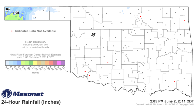
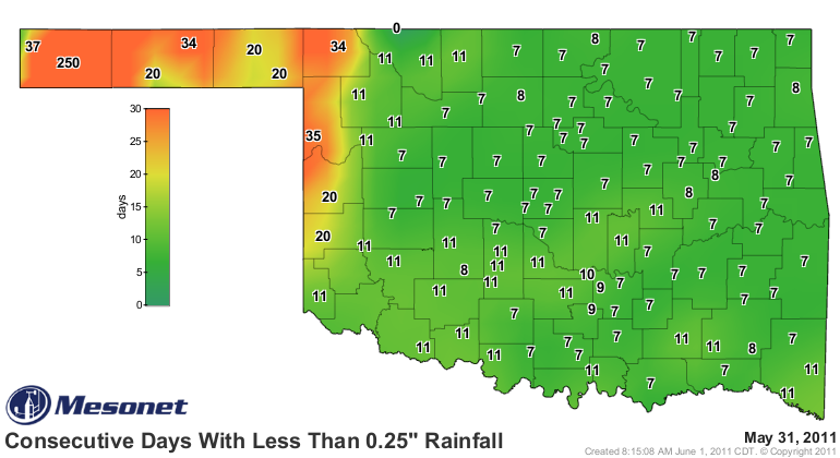
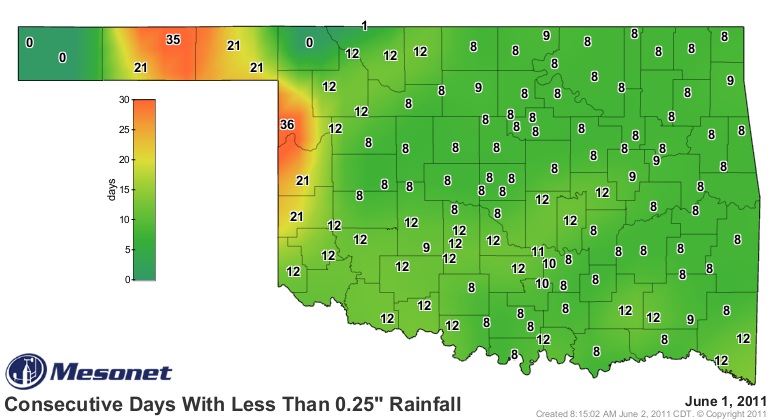
Now to the bad streak that was broken. The Boise City Mesonet site FINALLY
received a quarter-inch of rainfall in a single day, breaking their streak of
250 days (September 24, 2010-May 31, 2011)! In fact, just to put an
exclamation point on the snapped streak, they went ahead and collected 1.05
inches last night from some thunderstorms.
http://ticker.mesonet.org/archive/20110602/rainrfc.24hr.png
So the quarter-inch daily rainfall map went from this:
http://ticker.mesonet.org/archive/20110602/mesonet.rainfall.quarterinch2.png
To this:
http://ticker.mesonet.org/archive/20110602/mesonet.rainfall.quarterinch.png
Definitely not a drought buster, but it at least doubled their rainfall total
for the year.
Gary McManus
Associate State Climatologist
Oklahoma Climatological Survey
(405) 325-2253
gmcmanus@mesonet.org
==================================================
The OCS/Mesonet Ticker
https://ticker.mesonet.org/
To subscribe or unsubscribe from the Ticker
or for questions about the Ticker or its content
Phone or Email the Ticker Manager at OCS
Phone: 405-325-2253 Email: ticker@mesonet.org
---------------------------------------------------
-C- Copyright 2024 Oklahoma Climatological Survey
===================================================
|


 Tweet
Tweet